


Where in the West are people moving?
Also: Fire season arrives in Colorado, flood season in New Mexico. More.

⛈️ Wacky Weather Watch⚡️
Earlier this week I was gazing with some amount of wonder at the Watch Duty fire map. Wildfires were cropping up in nearly every corner of the West, from the slopes of Navajo Mountain to the forests southwest of Window Rock; from the Gila Wilderness to two large blazes in southwestern Utah; from the Madre Fire north of Santa Barbara to the Gothic Fire in Nevada.
Oddly, however, Colorado seemed to be dodging fire season, despite ongoing drought conditions. That all changed a couple of days later, as blazes were sparked — mostly by lightning, it seems — along both rims of the Black Canyon of the Gunnison, on the Uncompahgre Plateau, and outside Buena Vista. Meanwhile, the Deer Creek Fire raced through 4,000 acres of forest and brush on the slopes of the La Sal Mountains just over the Utah border in just a matter of hours.

This isn’t surprising. Even in a not-so-dry year one would expect to see smoke in the air in July, especially when hotter than normal temperatures (Arches National Park recorded 106° F on July 10) combine with afternoon thunderstorms that bring a lot of lightning but not much rainfall.
But it does seem a little bit odd to be worrying about wildfires when, not far away, people and houses are literally being carried away by floodwaters. First came the horrible and heartbreaking tragedy in Texas’ Hill Country. Then, just a day or two later, more than three inches of rain fell over a couple of hours on the South Fork wildfire burn scar in southern New Mexico, sending mud-and-debris filled flash floods careening through the community of Ruidoso, killing three and damaging hundreds of houses and infrastructure.

Ruidoso can’t seem to catch a break from climate change-exacerbated disasters. In April 2022, the McBride Fire ripped through the area, killing two people and destroying more than 200 homes. Then, last June, the South Fork and Salt Fires together burned nearly 25,000 acres and some 1,400 structures. Shortly thereafter heavy rains on the burn scar led to major flash flooding in the town.

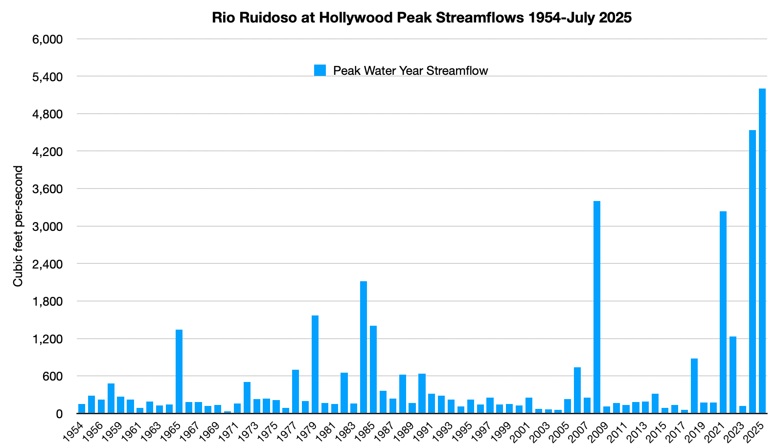
This time there was even more rain in a shorter period of time, sending a massive wall of water down the Rio Ruidoso. In less than an hour, the river’s flow jumped from about 7 cubic feet of water per second, to 5,200 cfs (with the gage height leaping from 1.45 feet to 18.42 feet). That’s the highest flow by far since records began in 1958, and 700 cfs higher than last year’s post-fire flood. It turned the creek into a destruction machine.
***
Climate scientists have concluded that climate heating most likely intensified the Texas storms, finding, “Natural variability alone cannot explain the changes in precipitation associated with this very exceptional meteorological condition.” And it certainly safe to say that the severity of both the New Mexico and Texas storms fit the pattern that one would expect to see as the climate heats up. Warmer air carries more moisture and has more energy, meaning it can lead to more acute storms.
But folks of a certain political bent think something else entirely is to blame: Deep-state “weather weapons” and cloudseeding. And they are serious enough about it that they are vandalizing weather radars and threatening to kill folks who work in the weather modification field. This WIRED article gives a good overview of the conspiracy theories at work.
It’s obviously a crock of cuckoo, for so many reasons. Deep state? Weather weapon? Targeting both red Texas and deep blue New Mexico? Yeah, no. Let’s say you do buy into all of that, then you might want to consider the questionable efficacy of said weather weapon.
Western water managers and ski areas have been trying to wring more snow from storms via cloudseeding for decades. Maybe, just maybe they’ve been able to increase precipitation from select storms by a as much as 10%, although that’s difficult to ascertain. And yet, they have not been able to end the megadrought that has seized the Southwest for two-and-a-half decades, they have not been able to concoct enough storms to fill Lakes Powell and Mead, and they have not delivered endless powder days to Rocky Mountain ski resorts.
Anyway, this is just an excuse to link to this old video on Project Skywater, which was the Bureau of Reclamation’s 1970s effort to use cloudseeding to increase snowpack in the Colorado River Basin to meet growing demands for water. It was a big, well-funded project. It didn’t yield much in the way of results. Nevertheless, it was the impetus for the San Juan Avalanche Project, which brought a herd of snow experts to Silverton to do a comprehensive study of avalanches and the potential impacts all of that new cloudseeding-yielded snow would bring.
Sorry for the poor production quality of the video, but it’s almost as old as I am, so what do you expect? Besides, it’s got a cool soundtrack.
🤯 Crazytown Chronicle 🤡
It’s funny, back in 1971, the Interior Department (via its Bureau of Rec) was putting out informative videos about attempted weather modification. Now they are spewing MAGA-cult propaganda that shouts Kim Jong Un. Oh how our public lands overseer has fallen! It refers to Trump as the “most iconic” president ever. Whatever the frack that means. Oh, also, expect an “iconic” fireworks show over Mt. Rushmore next year.
📈 Data Dump 📊
After pondering population growth and development in Kanab, Utah, in the last dispatch, I figured I’d take a look at where in the West folks are moving to in the post-COVID era. The answer: Arizona. Specifically Pinal County, which had the highest net in-migration rate1 from 2023 to 2024, and Maricopa County, which had the largest number of net in-migrants. San Juan County, Colorado, is also in the top 20 for migration rates, but that wasn’t exactly due to a massive population influx to the mountain town. It had a net in-migration of just 20 people, which is a lot in a county of 800 people.

Keep in mind this is not the population growth rate, which includes births and deaths, but just the migration rates (though the two closely correspond).
Many of these counties are the usual suspects, but there are some surprises. San Miguel (Telluride), Eagle (Vail), Hinsdale (Lake City), and Dolores (Rico) counties, all in Colorado, have some of the highest rates of out-migration in the West. These same counties had relatively high net in-migration between 2021 and 2023. The cause of the exodus is not clear, though it might have to do with high housing prices, which plague all of these places.
Pinal County’s appeal is probably related to it becoming an electric vehicle, battery, and other high-tech manufacturing hub in recent years, boosted by Biden-era incentives. Congress and Trump killed many of those incentives with their recent budget reconciliation bill, possibly jeopardizing at least some of the new firms and jobs. It will be interesting to see if the 2024 migration trends can continue. Neighboring Maricopa County continues to draw tens of thousands of new residents and air-conditioning-dependents each year, never mind that the mercury hit 118° F a couple of days ago.
And now, on to the charts.
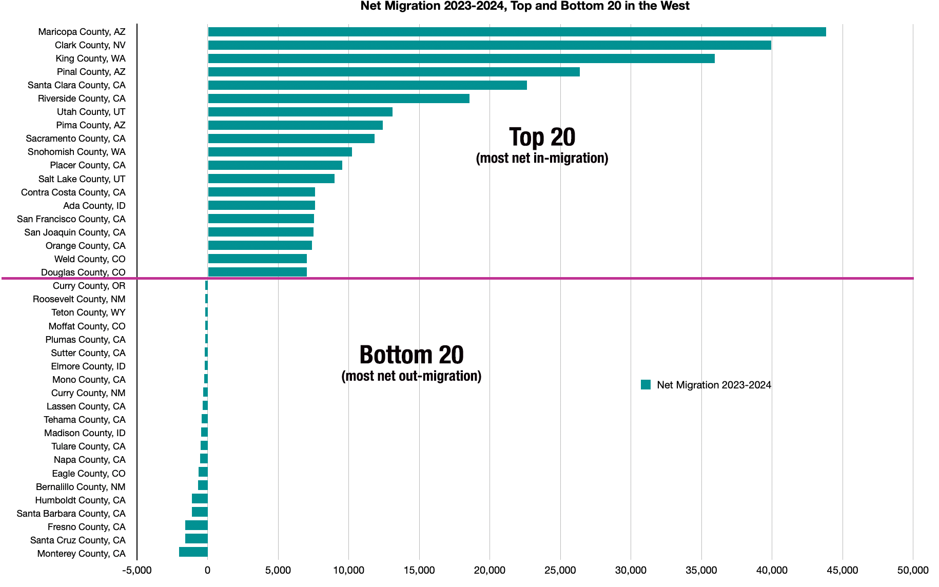

Net migration 2024/population 2023
"iconic president"? That could mean anything. But in Trump's case, nothing good.Those doppler radar vandals in NE OKC? They claimed to be a militia and were proudly combating weather terrorism maybe on behalf of their iconic president.
Some of this migration looks to me like post-COVID bounce back as people return to the major metros for jobs…or being called back to the office.
The second figure mostly includes low population rural counties where one job center, such as a lumber mill, closing or opening could cause a substantial percentage change. Or even the completion of a housing development could cause a sizable population shift (percentage-wise).