


Map Day: Fire risk, O&G threats, Snowmelt timing
Plus: America is broken

To kick things off on this grim day (scroll to the last item for the grimmest piece) let’s look at some, well, kind of grim maps. The first one is this crazily specific wildfire (and flood) risk mapping tool put out by the nonprofit First Street Foundation. Just enter your address and voila! It will tell you what your “risk factor” is (1-10, minimal to extreme); how that factor is likely to change in 30 years; the likely intensity of a wildfire on your property; and will even tell you about the vulnerability of your home (or one you’re thinking of buying — the tool has been incorporated into some real estate websites).

I decided to test it out. I entered the address of a home in the wildland urban interface on Durango, Colorado’s, western edge which is under a wildfire pre-evacuation order as I write this. That home (with a Zillow estimated sale price of $2.2 million) has a wildfire risk of 6/10, making it “major;” it has a 14% chance of being in a wildfire in the next 30 years; and the building material and roof type are “high risk.” Sounds about right. The “Historic Fires” function didn’t work quite as well, showing just one fire that had burned nearby in the last decade or so.
Next I entered an address of a building in Montezuma, New Mexico, which is in the Hermits Peak Fire burn area. It got a 10/10 “extreme” risk rating; it has a 74% chance of burning in the next 30 years; the average flame height of a wildfire would be about 6 feet.
It’s all pretty cool to play with, especially for a map junkie like me. I am curious to see how it’s used. Will homeowners take steps to “harden” their property against wildfire based on what the tool tells them? Will hopeful homebuyers shy away from extreme risk properties? Will property values drop in places that are likely to burn in the next decade?
Along somewhat similar lines, Earthworks and FracTracker Alliance have released a new “Oil and Gas Threat Map,” showing the location of every oil and gas facility in the U.S. They then drew a half mile radius blob around each of them, indicating the area in which research shows oil and gas pollution can be detected at concerning levels (dependent upon the facility, of course). The map’s creators then quantified the number of people within those threat zones. A couple of their findings:
17.3 million: Number of people who live within the threat radius in the U.S.;
5.7 million: Number in threat zones who are people of color;
12,445: Number of schools and daycares within the threat radius;
170,000: Number of Weld County, Colorado, residents within the threat radius;
12,763: Number of oil and gas wells, natural gas compressor stations, and processing plants in San Juan County, New Mexico.
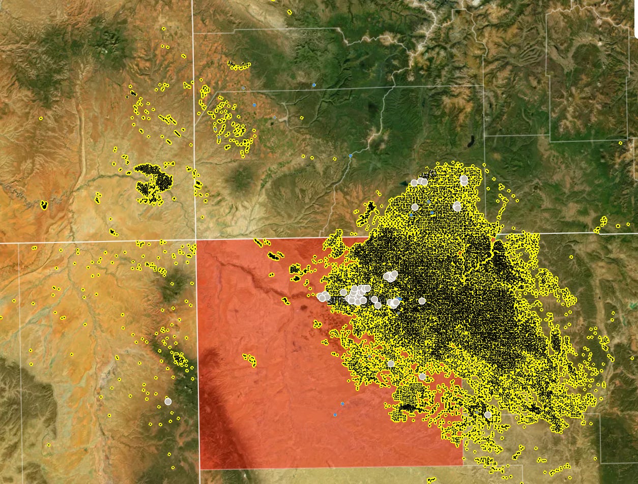
The map also allows you to click on the oil and gas facility and see its name and operator. The only problem with it is that in places like the San Juan Basin in northwestern New Mexico and southwestern Colorado, the oil and gas facilities are so pervasive that there are hardly any land, houses, schools, or anything else that don’t fall within the threat zone. The cities of Farmington, Aztec, and Bloomfield have all been consumed by the yellow threat zone blob; the same goes for Durango’s southeastern suburbs, including all of Three Springs.
This is worrisome because oil and gas wells tend to leak methane, which is a potent greenhouse gas and can build up and explode; benzene, a carcinogen; hydrogen sulfide, which is lethal at high concentrations; and volatile organic compounds which are health hazards. Over in California, for example, regulators — tipped off by environmentalists — discovered some seriously big methane leaks at orphaned wells near Bakersfield residential neighborhoods.
Take a look and see how threatened your community is.
As long as we’re doing the map thing, here’s one showing what we’re seeing play out on the ground this spring: The snow is melting earlier than it once did. Runoff’s already peaked and the snowmelt virtually vanished in the Southwestern Colorado high country, weeks earlier than “normal,” whatever that means.

And here’s what an early spring runoff peak looks like: The river looks pretty healthy in mid-May, given that levels are way above the median. But then the snow vanishes and bammo, levels plummet quickly. Could be a bottom-scraping summer for river rafters.


So, it happened again. A man, always a man, equipped with body armor and two assault rifles — weapons made not just for killing people, but to tear them apart — walked into a Texas elementary school and murdered at least 19 children and two adults. It happened just ten days after a racist terrorist walked into a New York supermarket and gunned down ten people. It was the tenth mass murder of the year and the 213th mass shooting. So far this year, 17,194 people have been killed in gun violence in the U.S.
Law enforcement officials likely will determine that the Texas and New York shooters were “lone gunmen.” They are not. They are terrorists supported and prodded on by a slew of accomplices, co-conspirators, aiders and abetters. They had the explicit backing of the gun rights lobby, gun manufacturers, and the politicians they have purchased. They were egged on by the purveyors of hate, spewing bile every night on cable television, and encouraged by the firearm fetishizers like my representative in Congress. They were enabled by spineless politicians and those who demand the right to walk around in public with a deadly weapon strapped to their hip. And they were nourished by the strain of violence deeply embedded in American culture.
The epidemic of mass shootings in America is perhaps the most effective act of terrorism ever inflicted, in that it injects us all with a little nodule of terror that re-emerges every time we send our kid to school or our spouse to the grocery store, vaguely wondering whether they’ll come back alive or torn apart by battlefield weapons bought down at the local pawn shop.
The Texas shooter reportedly purchased the AR platform rifles he used the week before his rampage, putting him in a club that includes the more than 18 million Americans who bought firearms during 2021 (if this writing sounds familiar, it’s because it’s an echo of what I wrote following another mass shooting last year). Had it been more difficult or impossible for him to buy the weapon, the shooting may not have occurred. At the very least, if it were illegal to sell these weapons, the gun industry would no longer profit from these massacres. But any efforts to enact a longer waiting period, tighten background check restrictions, or ban semi-automatic rifles will run up against America’s gun-clinging culture, which is to say the increasingly radicalized Republicans in Congress and the powerful gun lobby. It’s the same old pattern, happening over and over again, and it looks like this:
Mass shooting —> “thoughts and prayers” —> consider minor gun control measures —> “They’re coming for our guns!” —> surge in gun sales —> massive profits for gun manufacturers and industry groups like the NRA —> bigger donations from gun industry to politicians to ensure that they block gun control —> mass shooting … and, well, you get the picture.
That’s not culture, it’s greed. It’s ignorance. It’s stupidity. And, most of all, it’s a strain of bloodlust endemic to America, the same urge that drove and expedited the American project of settler-colonialism and Western expansion and that endures today. That is the root of the problem, not guns. But guns are the tools that manifest this illness in the most deadly fashion. That we can’t even begin to regulate these weapons is a sign that America truly is broken.

And on that note, y’all should subscribe to my friend Wayne’s newsletter, Civil Conversations:

I love maps! Thank you for sharing those. I am very interested in exploring the fire risk map.
I wonder if anyone has plotted all the places someone can purchase a gun in the United States? I heard on NPR's Marketplace, yesterday, that there are more gun stores in the US than there are Starbuck's Coffee shops on the planet. What we need is a map plotting all those locations, plus gun makers, plus ammo makers so we can make sure there is a 1:1 ratio with those locations and places that are burnt to the ground... A campaign to RETURN FIRE!
Is there a link for that snowpack map?