Can we engineer our way out of drought?
The Low Flow Conveyance Channel suggests the answer is "no."

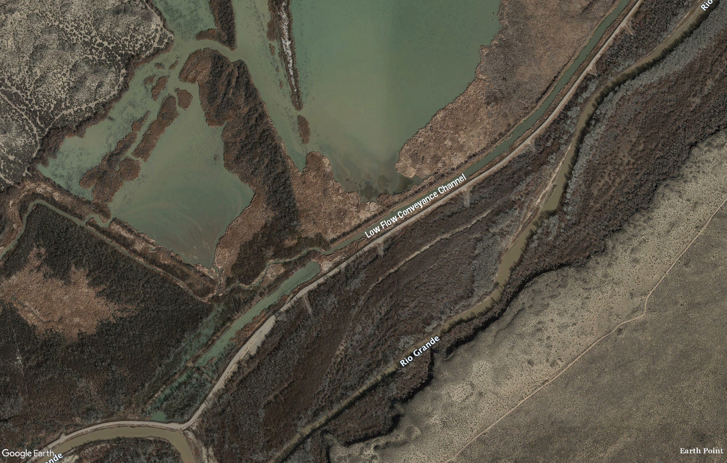
A few months ago a reader and Western water expert clued me in on recent developments related to the Low Flow Conveyance Channel. Had she told me this in person I probably would have blushed and fumbled around for an intelligent response before finally resigning and asking:
Say, what?!
Because, well, I had no friggin’ idea what she was talking about.
And yet, I should have known, because the Low Flow Conveyance Channel — or LFCC — is a classic example of how folks in the West try to engineer their way out of the region’s aridity and, ultimately, fail.
The LFCC might be considered the infrastructure love-child from the coupling of the Rio Grande Compact and, well, silt — a lot of it. The compact, signed in 1938, divided the waters of the Rio Grande between Colorado, New Mexico, and Texas. Whereas the Colorado River Compact allocates a set amount of water to each group of states, the Rio Grande Compact uses a more complicated distribution formula based on flows at specific river gages.
Among other things, it requires New Mexico to deliver a certain percentage of the Rio Grande’s flow to Elephant Butte Reservoir, where it is stored for Texas. This is strange, I know, because the reservoir is in New Mexico, not Texas, and not even that close to the latter state. But these water compacts can be like that. New Mexico can accrue up to 200,000 acre feet of water debt to Texas and still be in compact compliance, giving the upstreamers some breathing room during dry years.
The Compact went into effect in 1939, a dry year on the Rio Grande; 1940 was similarly meagre, with a peak streamflow under 3,000 cfs at the Otowi Bridge gage. But the Rio flooded, big time, in 1941 and 1942, peaking above 22,000 cfs at Otowi. That kind of big water tends to pick up big silt — especially from the Rio Puerco, a Rio Grande tributary — and when the river started losing energy at the slackwater above Elephant Butte Reservoir, the sediment fell out of the flow, accumulating on the river bed. If you’ve ever rafted the lower San Juan River, you’ve experienced a similarly silty phenomenon below Slickhorn Canyon.

The silt filled in and plugged the existing river channel, sending the water out across a much wider, shallower plain, and forced the railroad to raise its tracks repeatedly along a section that crosses the river. During ensuing low-water years, the river was so spread out that most of it evaporated or seeped into the silt or was sucked up by encroaching tamarisk before reaching the reservoir. Before long, New Mexico was deep in water-debt to Texas, and in 1951 owed the downstream state 325,000 acre-feet, putting New Mexico out of compliance with the compact.
This is where the engineers come in. In order to get the river to Texas they would divert it around the river bed, kind of like providing fish passage around dams for salmon. And they would do this by building a deep, narrow, 75-mile long ditch from San Acacia to the reservoir that would carry water and silt more efficiently and result in less evaporation. It would be called the Low Flow Conveyance Channel because it would convey the river during low flow. Construction began in 1951 and the LFCC went into operation in 1959.
For the next two decades, the LFCC did what it was supposed to do: Carry up to 2,000 cfs of the river’s flow around the river, itself, and deposit it in Elephant Butte Reservoir, where it was stored for Texas. New Mexico’s substantial water debt slowly shrank, finally disappearing in 1972. Despite the channel’s name, during this time it carried most of the river’s water during high flows and low, thus depriving the riparian zone of its life-giving river and altering the ecosystem.
The 1980s were notoriously wet years for most of the Southwest and somewhat perilous times for the infrastructure built to help states comply with water compacts. Glen Canyon Dam, constructed primarily to allow Upper Colorado River Basin states to deliver the obligated amount of water to the Lower Basin, was pushed to the brink by massive snowmelt in 1983 and, to a lesser extent, in 1984.
The Rio Grande ran large during those years, too. Elephant Butte Reservoir filled up completely, inundating the lower reaches of the LFCC. Silt happens, it turns out. When the reservoir levels declined several years later, the last 15 miles of the channel had essentially disappeared under a thick layer of sediment. No longer able to carry water to the reservoir, the LFCC was shut down in 1985 and hasn’t been used to convey the Rio Grande since.
But the first 60 miles or so of the LFCC remains, running alongside the Rio Grande like its more linear twin, separated by an earthen levee built to keep a flooding river from inundating and wrecking the canal. Bizarrely, the river channel is about 10 feet or more above the canal, due to all of that sedimentation over the years, making flooding more likely. And that means more engineering, and maintenance dollars, are required to protect the engineered canal. In a weird Anthropocene-esque twist, the canal now serves an environmental purpose: It catches and conveys irrigation runoff and groundwater to the Bosque del Apache National Wildlife Refuge, keeping the wetlands there wet.

As Rio Grande flows continue to decline and New Mexico piles up water debts to Texas, the possibility of reopening the LFCC grows. The Middle Rio Grande Conservancy District, which acquired the northern end of the channel from the feds, has talked about using it again to get more river water downstream to Texas (thereby freeing up more Rio Grande water for New Mexico irrigators). And the state engineer’s office asked lawmakers to budget $30 million for the LFCC.
But it would take far more than that to clean out, rehabilitate, and extend the lower section so it could reach the shrinking reservoir. And even then, it could only be used on a limited basis, since diverting the entire flow of the river would run up against endangered species laws and other environmental concerns. Elizabeth Miller wrote a strong piece for NM In Depth about efforts to reopen the channel and environmentalists’ concerns. It’s well worth a read.
For now, however, the Low Flow Conveyance Channel will stand as a reminder that while engineering our way out of a short-term drought may be somewhat effective, it usually doesn’t work in the long-term. To survive ongoing aridification we must dispense with dams and canals and rethink our relationship to this landscape and overhaul the way we use diminishing amounts of water.
The state and conservancy district know that we face drastic declines in flows, comparable to those on the Colorado river. The emphasis is all about somehow increasing supply, rather than taking the difficult steps of addressing demand. New Mexico's antiquated water management agencies have no mandate to protect the natural environment and the state's depleted rivers only get protection through the federal Endangered Species Act. The grasping at a half century old channel as the solution to meeting the state's compact obligations to Texas is all too typical.
In Ms.Hill's article:
" So far, none of the work to remove brush and maintain roads along the channel looks likely to injure endangered Rio Grande silvery minnow—it’s never been good habitat for them—and the one nesting Southwestern willow flycatcher in the area was unlikely to be disturbed by the work, according to the Service’s analysis for the Bureau of Reclamation." Per the US Fish & Wildlife!
Frankly, human management doesnt always become HUMANE management of other species.