
USDA chief: Give me more cattle in the national forests!
Plus a Messing with Maps look back at the summer of 1776

🐮 Grazing Gazette 🥩
Last month, U.S. Agriculture Department Undersecretary Michael Boren issued a memo, with a preamble by Agriculture Secretary Brooke Rollins, to Forest Service employees directing them on “advancing grazing on Forest Service” lands. It’s a curious, sometimes alarming memo. And, as is customary for the Trump administration, its authors are a bit confused about history.
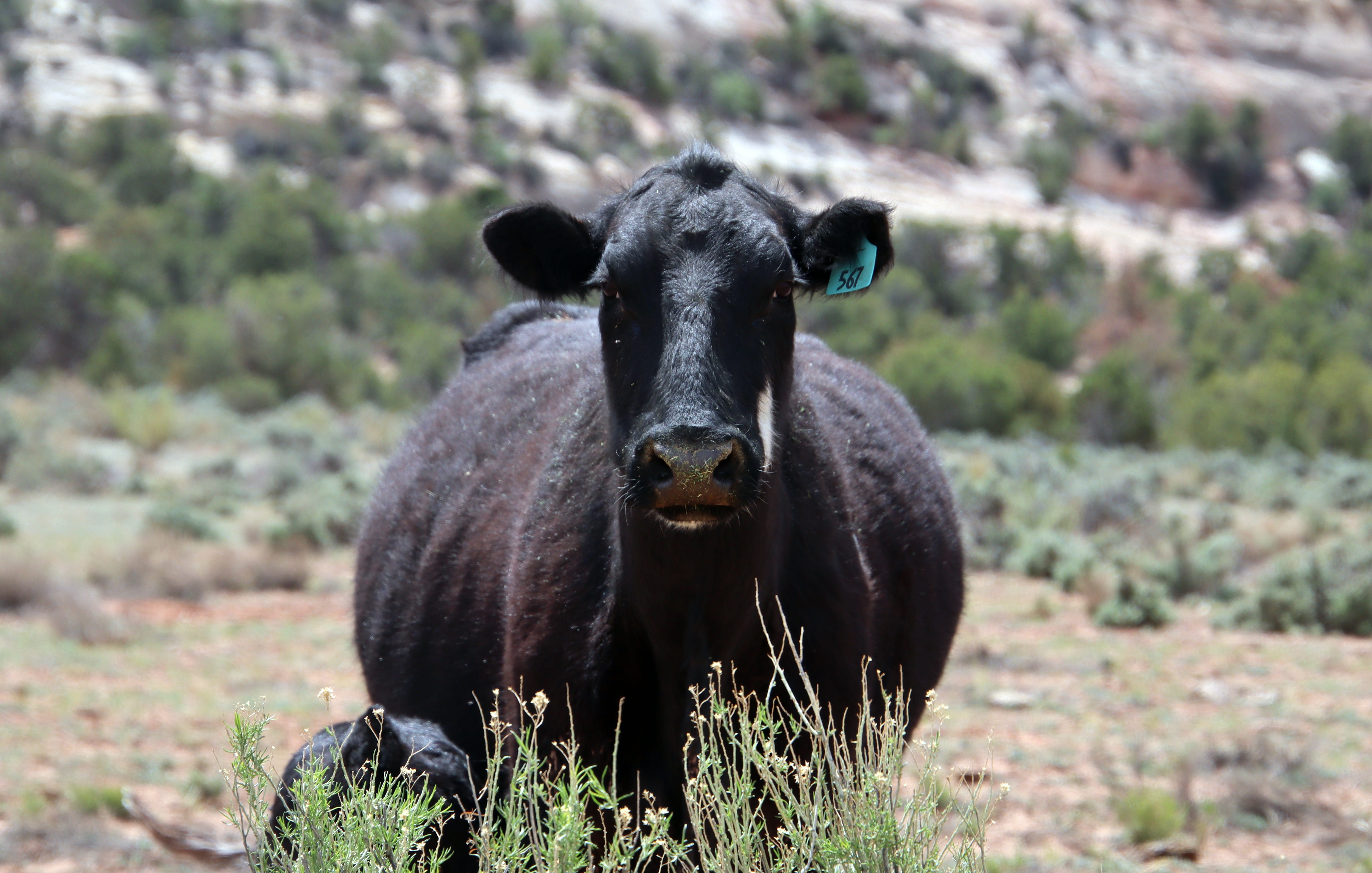
While most public lands grazing occurs on Bureau of Land Management land, the memo reminds us that national forests also host more than 2 million cattle, sheep, and horses and burros. The current administration desperately wants more livestock on America’s forests, although it’s not clear why.
The memo directs the agency’s staff to streamline the permitting process, to treat public lands1 ranchers with deference and respect, and to bring more “flexibility” to prairie dog “management,” which I assume means they want more efficient ways to kill the animals. It also guides line officers to offer up unallocated forage “to the maximum extent possible” and work to “solicit interest/applications from the eligible ranching community” to occupy vacant and closed grazing allotments. The goal? To add 500,000 head months2 of cattle and other livestock to national forest lands over the next two years, purportedly in part to “maintain the fabric of rural America.”
The fabric of rural America very well may be frayed, but throwing a bunch of half-ton methane dispensers onto drought-addled national forests to gobble up what grass and wildflowers remain in high-country meadows, trample stream banks, sully trout habitat, and make a mess out of trails, isn’t going to repair it.
Boren acknowledges that grazing on national forests has declined over the last 60 years in part due to “changing rangeland conditions” and “catastrophic wildfire and variable moisture levels.” But he seems oblivious to the fact that in most of the West, moisture levels remain at an all time low, and putting livestock on that land would not only lead to some pretty skinny cows, but also would further decimate the drought-stressed soils and vegetation.
Ranchers nationwide are actually thinning their herds due to drought and rising overhead costs, and cattle numbers are at record lows this year despite high beef prices. That reduces the chances that Boren will actually have many takers for the vacant allotments.
Still, it’s concerning. With the top brass pressuring the entire agency to pull out all of the stops to get more livestock on the forests, it’s not hard to imagine a district ranger succumbing and permitting a vacant allotment — even one that a conservation organization bought out from a willing rancher to help wildlife or reduce conflicts.
Rollins, meanwhile, seems confused about the origins of the agency she oversees. She writes:
“Unlike the national parks, which were created primarily to preserve natural beauty and unique outdoor recreation opportunities, the founders of early national forests envisioned them as working with multiple objectives. The Organic Administration Act of 1897, under which most national forests were established, states: ‘No national forest shall be established, except to improve and protect the forest within the boundaries, and for the purpose of securing favorable conditions of water flows, and to furnish a continuous supply of timber for the use and necessities of citizens of the United States.’”
But she doesn’t seem to consider what Congress was trying to “protect” the forests from, because in the next paragraph she writes: “From those early beginnings, grazing has been an integral part of our nation’s national forests …” Yeah, not quite. Let’s step back a bit, shall we?
During the early and mid-1800s, the United States stole, conquered, purchased, or acquired by treaty hundreds of millions of acres of land in the West and declared it the “public domain.” The government then went about “disposing” of the land, giving it away or selling it for virtually nothing via the Homestead Act, the General Mining Act, the Pacific Railway Act, the Desert Land Act, and so forth. By the end of the 1880s, huge tracts of public land had been handed over to the railroads, to mining interests, to states, and to homesteaders, yet across the West hundreds of millions of acres still remained in the public domain, and nearly all of those lands were open to unrestricted grazing, timber-cutting, and the devastation that came with them.
Gifford Pinchot would later describe the period like this:
“Enormous areas of the Public Domain … were given ‘in aid’ to railroad and wagon road companies. … Thus natural resources were being developed and destroyed with the only objective being personal profit. For all intents and purposes, the Federal Government did nothing about it. At a time when, in the West, the penalty for stealing a horse was death … stealing the public land in open defiance of the law was generally regarded with tolerance or even approval.”
Albert Potter, the USFS’s first chief of grazing, called the 1880s the era of “spoilation,” writing:
“The pioneer stock grower, eager to reap the fruits of his early efforts, increased his herds to the full limit of his ranges. Quick profits and swollen fortunes naturally led to speculation and companies were organized to place incredible numbers of stock upon the range. Multiple settlers appropriated the choicest lands and competed with prior occupants in the use of the unappropriated lands. The permanent good was sacrificed to individual greed. The grazing lands were stocked far beyond their capacity; vegetation was cropped by hungry animals before it had opportunity to reproduce; valuable forage plants gave way to worthless weeds and the productive capacity of the lands rapidly diminished.”
Unfettered livestock grazing wasn’t just diminishing the forage, but also wrecking watersheds. In southeastern Utah, the big livestock companies, notably the New Mexico and Kansas Land and Cattle Company, ran thousands of cattle and sheep across the once abundant grasslands on the slopes of the Abajo and La Sal Mountains, reducing them to denuded, dusty, gullied, flash-flood-prone wastelands. At one point, allegedly out of spite, the Carlisle livestock concern turned out thousands of sheep on the upper branches of Montezuma Creek, Monticello’s source for drinking water. Bacteria from the sheep feces contaminated the water, leading to a typhoid outbreak in Monticello that killed eleven people.
In hopes of mitigating the wreckage, in 1891 Congress passed the Forest Reserve Act, giving the president the authority to withdraw areas from the public domain3 as forest reserves, to be overseen by the Interior Department. Six years later Congress passed the Forest Management or Organic Administrative Act, which gave the previous law some teeth by providing a framework for managing the reserves. In 1905 President Theodore Roosevelt transferred management of the reserves to the Department of Agriculture and named the agency the Forest Service, appointing Gifford Pinchot as his chief forester.
Together, Pinchot and Roosevelt represented a major shift in the way the government managed and society perceived and treated the public lands. Roosevelt set aside some of the nation’s most cherished landmarks as national monuments. Pinchot believed that humans should utilize the forests and grasslands but that they should do so in a more sustainable manner so as to save some of the timber and forage for future generations. This conservationist ethos came to be known as Pinchotism, a term spit derogatorily by western politicians who were beholden to the extractive industries, such as Republican senator Weldon Heyburn from Idaho. Employing the same rhetoric that would later be used by the Sagebrush Rebels, Heyburn derided the forest reserve laws, suggesting that they amounted to theft of the “people’s forests.”
The question of livestock grazing on the forest lands was a contentious one for years. Under the Forest Reserve Act, grazing was effectively banned on the new reserves. After the Organic Act passed, the General Land Office began permitting grazing by cattle and horses, but not sheep — which were generally seen as far more destructive4 — on the condition that it didn’t harm the forests. Eventually, Pinchot succumbed to the sheep industry lobby and grudgingly allowed grazing on some forests, causing a schism between him and John Muir, who was strongly opposed to sheep in forests.
Over the ensuing years, the Forest Service developed a grazing policy, permitting system, and set fees — very low ones — based on the number of animals, much to livestock operators’ dismay. This was in stark contrast to the lands in the public domain, where grazing remained a free-for-all until Congress passed the Taylor Grazing Act in 1934.
These minimal restraints, however, were not enough to stop the destruction. In the years following World War I, Forest Service officials found that grazing was still wreaking havoc on vegetation and spawning more erosion. Yet every time they tried to reduce the number of livestock on the land, they were hit with legal challenges, lobbying campaigns, and political pressure.
Ultimately the backlash to Pinchotism elevated Warren G. Harding, a friend to the industries that wanted free rein over the public lands, to the presidency. Harding chose Albert Bacon Fall to be his interior secretary, who immediately went about rolling back regulations and doing his best to erase the legacy left by Pinchot and Roosevelt, including opening up the public domain and Indian land to coal mining and oil and gas drilling. While Trump and his minions like to compare themselves to Teddy Roosevelt, in reality they much more closely resemble Harding and Fall.
🔥 Wildfire Lookout 🔥
A number of ferocious wildfires continue to rage across the Interior West. One of the largest is the Babylon Fire in Bears Ears National Monument, which had grown to over 81,000 acres as of Thursday night. It’s also on Forest Service land and is burning through some large, active grazing allotments, including the Babylon, Gooseberry, Twin Springs, and Cottonwood, and looks like it’s making its way onto some BLM allotments as well.
The Gold Mountain Fire near Ouray, Colorado, had grown to about 21,000 acres, with the Ferris Fire near Dove Creek reaching nearly 29,000 acres. Fire weather is expected to continue through the weekend.
🗺️ Messing with Maps 🧭
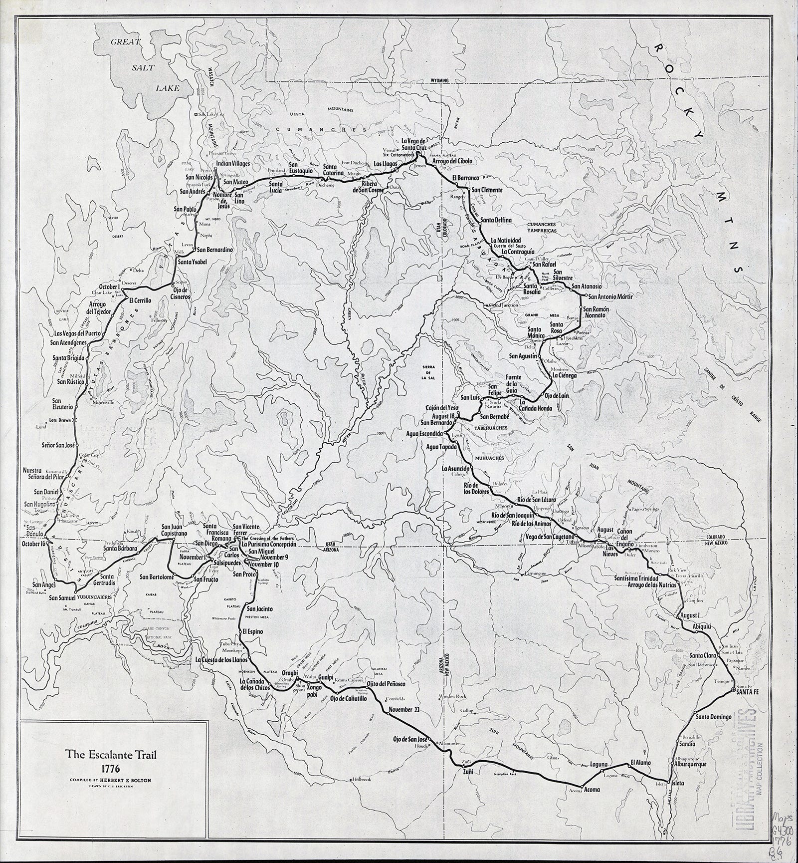
Note: On the occasion of America’s 250th birthday, I’m rerunning this piece from a couple of years ago on the July 1776 Escalante-Dominguez expedition that occurred even as the American Revolution was unfolding far to the east.
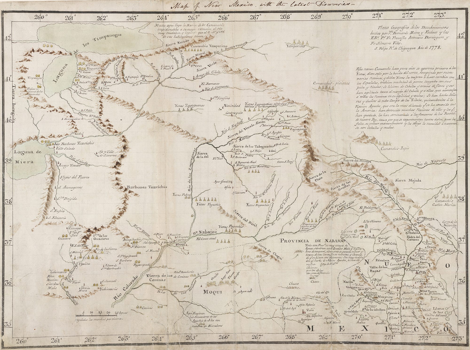
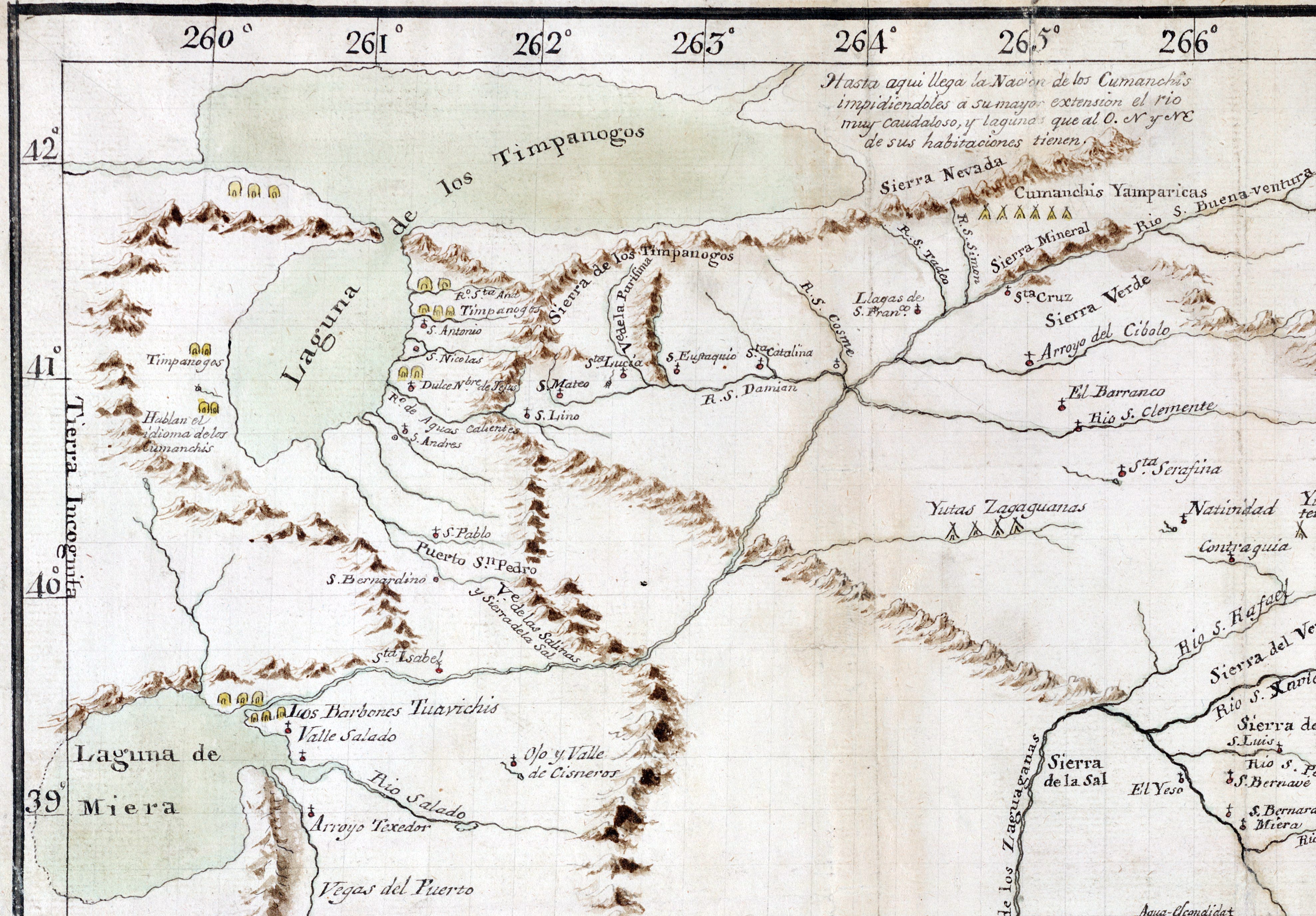
I’ve been fascinated by maps of all sorts for as long as I remember. Don Bernardo Miera y Pacheco’s map, drawn following the 1776 Escalante-Dominguez expedition, has intrigued me for nearly as long. And the more I look at old maps of the region, the more interesting this one becomes, in part because it’s far more accurate, especially in its depictions of the Four Corners Country, than maps made a century later by U.S. surveyors.
In July of 1776, Atanasio Dominguez and Silvestre Vélez de Escalante, a couple of Franciscan priests, headed out with a motley crew from Santa Fe in search of a route to California. Instead, they ended up going up what is now Colorado’s Western Slope and through the heart of Ute territory, across to the Great Salt Lake, dropping down through western Utah, and finally looping — somewhat erratically — back to Santa Fe. But if they didn’t find California, they did leave behind relatively detailed journals and maps that give us insight into what the region looked like prior to the Euro-American invasion, and into early European colonists’ perception of the region.
The party set out from the Pueblo of Santa Rosa de Abiquiu, on the first day of August, effectively leaving the Spanish Empire. The country beyond was the domain of the Weenuchiu, Tabeguache, Caputa, and Mouache bands of Ute. Not wanting to provoke the Ute people any more than necessary — they had made that mistake before — the Spanish Crown forbade settlers from wandering into the territory of or trading with the Utes.
Still, the path they followed was well-established. Juan Rivera had travelled it a decade earlier, and he had followed well-established routes through a land that had been inhabited for millennia, and that had been intimately mapped in the collective consciousness of oral histories. Rivera probably wasn’t even the first Spaniard to tread these paths; mavericks defied the travel and trade ban to acquire deerskins or to try their luck in the mineralized slopes of the high San Juan Mountains. The Spanish mavericks, in turn, were merely following paths already well trodden by Ute, Diné, Paiute, and Pueblo travelers long before.
So it shouldn’t be much of a surprise that current day routes more or less follow Escalante’s and Dominguez’s path. From Abiquiu the party traveled northwest, roughly following Hwy. 84 about to Los Ojos/Tierra Amarilla, which they described as:
“The river’s meadow is about a league (2.63 miles) long from north to south, good land for farming with the help of irrigation; it produces a great deal of good flax and abundant pasturage. There are also the other prospects which a settlement requires for its founding and maintenance. Here it has a good grove of white poplar.”
This sort of assessment of a site’s suitability for a settlement is common in Escalante’s journals. Most places he deemed good for a village now have a village on them, from Arboles to Ignacio to Dolores to Hotchkiss, though none would be established for another century or more after Escalante’s journey.
They then cut westward, meeting up with the Navajo River near Dulce, which originates in what they called the Sierra de la Grulla, or the Mountains of the Cranes — now known as the South San Juans. Later they note that the headwaters of the Rio de Los Pinos are in the Sierra de la Plata, indicating that the entirety of what we now think of as the Western San Juans were then called the La Plata Mountains. When they reach the confluence with the San Juan River near Carracas, they write:
“El Río de San Juan carries more water than the Navajo, and they say that farther north it has good and large meadows because it flows over more open country. Together they now form a river as plenteous as El Norte in the month of July, and it is called Río Grande de Navajo for separating the province of this name from the Yuta nation.”
They called their camp “Nuestra Señora de las Nieves,” or Our Lady of the Snows, because they could see snow-capped peaks from there. This seems odd given that it was early August and they would have been looking at the south faces of the San Juans, where the snow should have melted months earlier. Maybe 1776 was a cold year, because later, they describe the passage between Durango and Hesperus like this: “the terrain is very moist, since it rains very frequently because of its proximity to the Sierra; as a result, both in the mountain forest — which consist of very tall and straight pines, scrub oak, and several kinds of wild fruits — and in its narrow valleys there are the prettiest of pastures. The climate here is excessively cold even in the months of July and August.”

They make it to the Big Bend of the Dolores River and then do some bending of their own, deviating from their westward course by 90 degrees for reasons I can’t figure out. Were their guides trying to avoid the rugged Canyon Country of southern Utah? Were they blindly following the path of their predecessor, Rivera? For whatever reason, they ended up heading north, encountering the Dolores River a second time near Cahone and a third time near Slick Rock.
The party tried to follow the Dolores River downstream (north), but was stymied by the narrow, twisty gorge, writing: “The canyon we named El Laberinto de Miera because of the varied and pleasing scenery of rock cliffs which it has on either side and which, for being so lofty and craggy at the turns, makes the exit seem all the more difficult the farther one advances.” They turned eastward into the Big Gypsum valley, then toward Naturita and Nucla, before crossing the Uncompahgre Plateau where they found “deer and roe and other animals breed, and certain chicken fowl the size and shape of the common domestic ones, from which they differ in not having combs. Their flesh is very tasty.”
They dropped down to what they call the El Rio de San Francisco north of Montrose and that the “Yutas” call Ancapagri — i.e. Uncompahgre — or “Red Lake”, “because they say that near its source there is a spring of red-colored water, hot and ill-tasting.”
It seems that part of the reason Miera’s maps somewhat accurately depict areas the party never journeyed to is because they spoke with the Indigenous people who intimately knew the country. This is in sharp contrast to U.S. maps drawn a century later, which depict much of southeastern Utah as a big blank spot, with the San Juan River vanishing into the desert after passing the Four Corners. Miera y Pacheco’s map, meanwhile, accurately shows the stream meeting up with the Colorado in Glen Canyon.
That said, Miera y Pacheco does make some errors. He has the Gunnison River (San Xavier) running into the Dolores River near the present site of Gateway (passing through the Unaweap Gorge, perhaps?), and his maps appear to have the Green River (Rio San Buenaventura) flowing through the Wasatch Range and into Utah Lake.
At Montrose the party again took an odd route, going up the Gunnison River, in a northeasterly direction, rather than following it downstream to the northwest, up and over Sierra del Venado Alazan (Mountain of the Sorrel-Colored Deer), or Grand Mesa, before getting back on course (sort of) and making their way to the Great Salt Lake. It wasn’t until that point, when winter was starting to set in, that they realized maybe they should have taken a different route, and that Monterey, their final destination, was still a long ways off.
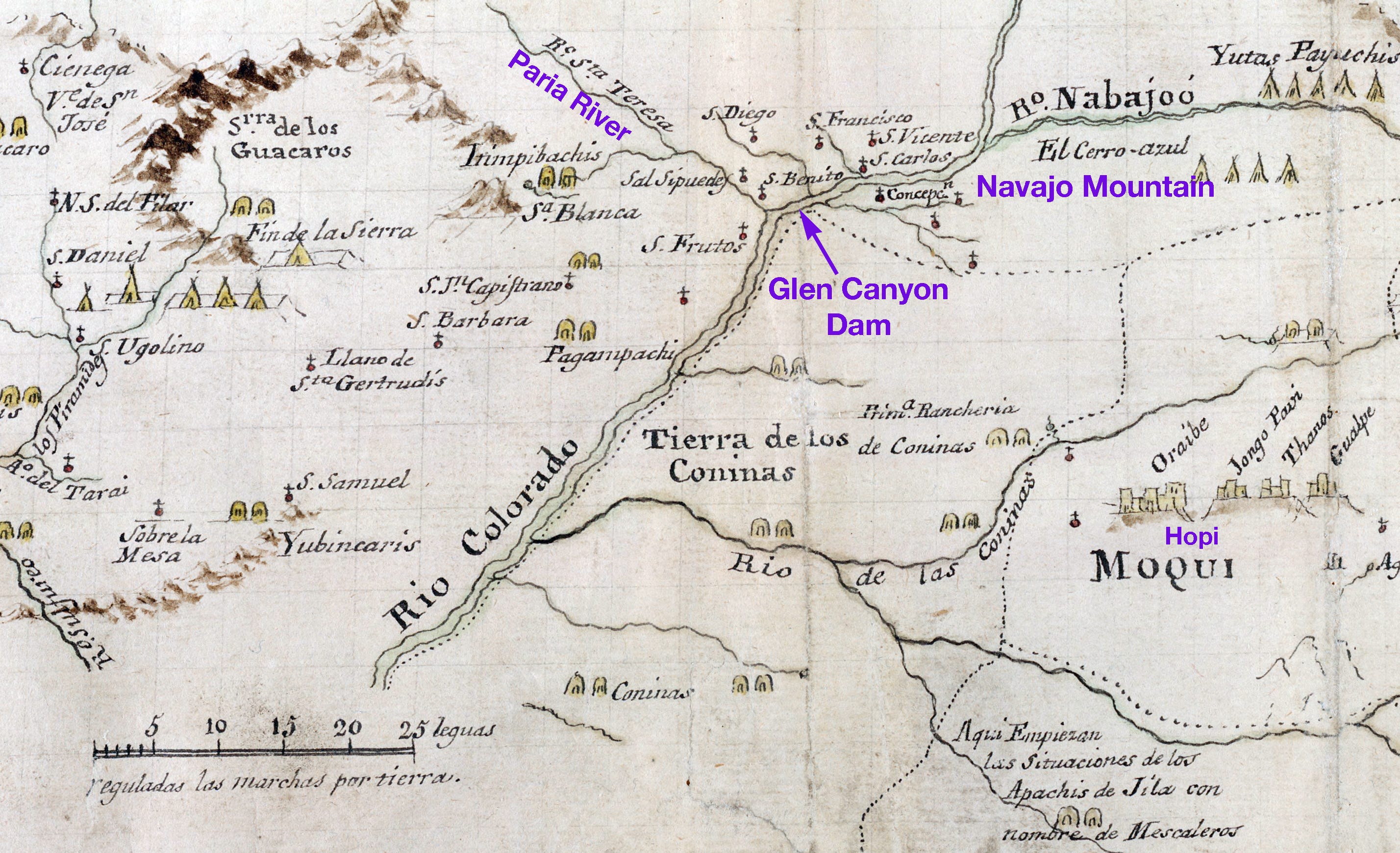
So they went south, all the way down to St. George, before turning back to the east, Santa Fe-bound. This is where it gets interesting, because their guides were not familiar with the country (what we would now call the Arizona strip) they were headed for. And yet, even though their route-finding was sometimes determined by drawing lots, they somehow managed to encounter the Colorado River at one of the few places they could get down to it, just downstream from the Paria River. Crossing the river, itself, wasn’t so easy.
“We were surrounded everywhere by plateaus and inaccessible peaks; therefore two of our men who were good swimmers entered the river naked, carrying their clothes on top of their heads. It was so deep and broad that the swimmers, in spite of their skill, were scarcely able to reach the opposite bank, abandoning in the middle of the river their clothing, which they never saw again.”
So they built a raft of logs, and “Father Fray Silvestre, accompanied by the servants, tried to cross the river; but although the poles they used to propel it were about five yards long, they did not touch bottom even a short distance from the bank.”
It was late October by then and, “Not knowing when we would be able to leave this place, and having already eaten up the meat of the first horse, the pine kernels and the other provisions we had bought, we ordered another horse killed.” Desperate, they hiked up the Paria until they were able to climb up to the plateau, then dropped back down to the Colorado River in Glen Canyon in a place they called San Diego. Finally they found a place where the canyon and river widened — now inundated by Lake Powell — and they were able to cross. After climbing out of the canyon: “We found today many Indian tracks, but saw no one. So many wild sheep flourish here that their tracks look like great herds of domestic sheep. They are smaller than the domestic variety, of the same shape but much swifter.”
The party finally reached Santa Fe and in the ensuing years Miera y Pacheco created at least two maps of the country they had traveled through.
When I use the term “public lands” I’m referring not only to BLM lands, but also to national forests, national parks and monuments, and national wildlife refuges.
Head Month is the U.S. Forest Service term for a cow-calf pair eating public forage for one month. It’s similar to an Animal Unit Month on BLM land.
When land is “withdrawn” from the public domain, it simply means that it is no longer available for “disposal.” That is, it can’t be privatized via homesteads or mining claims.
During a meeting with Colorado stockmen in 1905 to discuss grazing fees, Teddy Roosevelt reportedly pounded the arm of his chair with his fist and declared: “Gentlemen, sheep are destructive.”
Excellent E-D history, very well done! It's always interesting to consider the original names for places (Chomolungma - Everest; Denali - McKinley; Río de los Zaguaganas - Colorado River(??)
And cows ... just talking about cows is annoying ... cows?