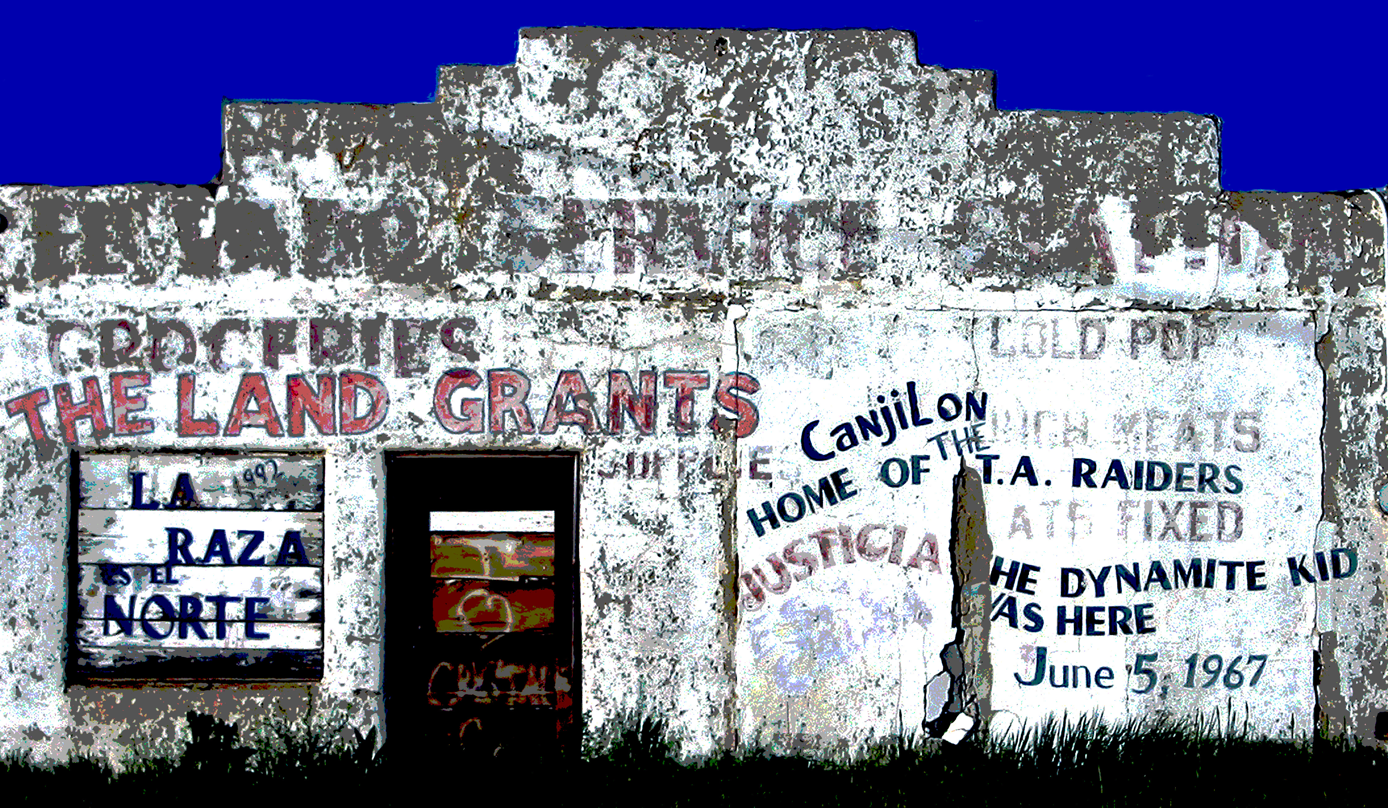
Uranium mining in the Chama Valley?
Also: Public lands for affordable housing in Las Vegas; Images of the Big Fat Melt Off.
⛏️ Mining Monitor ⛏️

The so-called uranium mining renaissance mostly remains in the hype phase. There’s plenty of talk of acquisitions and exploratory drilling and purportedly spectacular finds, but — with a few exceptions — there’s very little action. Even existing mines that have been in “standby” mode for years, supposedly just waiting for market conditions to improve, still aren’t shipping any ore to the mill.
But that doesn’t dim the buzz any. Not only is it intensifying, but it’s spreading out geographically. Most of the drilling and speculative claim-staking is happening in the Lisbon Valley in southeastern Utah and surrounding areas, along with a handful of mining proposals in the Grants uranium belt in New Mexico. Now Gamma Resources is going a little further afield by collecting claims on U.S. Forest Service land in the Chama River watershed in northern New Mexico.
The Canadian firm’s 4,520-acre Mesa Arc Project lies about five miles south of the village of Canjilon. While this was never a uranium mining hot spot, the USGS mineral data system does include a uranium prospect here by the name of Horney Toad or Lucky Dog, though it doesn’t appear to have been a producer.
So far, the company has filed a notice of intent with the Carson National Forest proposing to drill 10 to 12 exploratory holes and construct drill pads and about 800 feet of new access road. But the forest has yet to formally launch the review process. Gamma also says it has hired SWCA Environmental Consultants to conduct an archaeological and cultural resources survey of the area.
Locals aren’t all that excited about the prospect of a uranium mine in their backyard. Source NM’s Patrick Lohmann reports that Moises Morales, a Rio Arriba County commissioner, Canjilon resident, and long-time land grant activist, is mobilizing opposition to the project.
It would behoove Gamma Resources to look into the history of the area to see what a formidable force they are up against. The Chama Valley is famous for its fierce resistance to outsiders trying to usurp their land — be it real estate developers, the federal government, or, I suppose, a mining company.
***
One company, Disa, is looking to produce uranium not by digging up ore, but by using something called high-pressure slurry ablation (HPSA) to extract the mineral from historic mine waste rock piles. Only it appears their attempts to get the novel technology off the ground is facing some hurdles.
In March, Aura Grit LLC filed an application with the BLM to use Disa’s HPSA process on the October pile, an abandoned mine located south of Gateway, Colorado, on a mesa above John Brown Canyon. But shortly after the agency began reviewing the proposal, Disa backed out, at least temporarily, and decided to make the technology’s debut at the smaller Mary Ann uranium mine waste pile in Montrose County. The plan of operations is not yet available.
The Nuclear Regulatory Commission’s environmental review of the Disa’s proposal to remediate abandoned mine dumps with HPSA describes the technology as involving …“… mobile units that use high-pressure water streams to remove source material from the mine waste, resulting in coarse material and fines concentrates. Disa expects that the coarse material would meet NRC requirements for release and would be reintegrated into the mine site soils. The fines concentrates would be transported to licensed low-level radioactive waste or uranium recovery facilities for disposal or recycling.”
Because the process is separating uranium and thorium fines from ore, it is considered a form of milling, not mining. And that’s an important distinction, because when you mill uranium ore, you leave behind mill tailings, which must be disposed of according to NRC and Environmental Protection Agency standards. Instead, the “coarse material,” as the waste is described, would be reintegrated into the mine site — even though it may contain radioactive and other harmful materials.
In its plan of operations for the October pile, Aura Grit said the process would require trucking in about 5,000 gallons of water per day (or 108,000 gallons per month) from a commercial well near Gateway.
If you’re looking to find these locations on a map, check out the Land Desk’s Mining Monitor Map, which is updated frequently.
Also, for an interactive map of all kinds of uranium prospects, mines, and mills, there’s Land Desk’s Uranium Mining in the Four Corners Country map derived from USGS data.
🌵 Public Lands 🌲

Over the last year or so, there have been some bad faith attempts — most orchestrated by Sen. Mike Lee, R-Utah — to take public lands out of the public hands and turn them over to developers. Amid all of the brouhaha over that, it can be easy to forget that a mechanism already exists for this sort of transfer, and it’s not always a terrible thing.
The Bureau of Land Management, for example, is looking to sell about 19 acres of land on the southern fringe of the Las Vegas metro area to the city of Henderson for affordable housing. The sale would occur under the Southern Nevada Public Land Management Act, which Congress passed in 1998 to allow the feds to dispose of isolated, hard-to-manage tracts within the urban area, and to acquire private inholdings. The idea was to give Las Vegas more room to grow, while also protecting more remote, environmentally sensitive lands by transferring them into the public’s hands.
The process makes a lot of sense in southern Nevada, generally speaking, because there are so many disparate chunks of BLM land scattered throughout the city’s streetscape. While they do provide a sort of open space, they also can exacerbate “leapfrog” sprawl and essentially end up being vast vacant lots sandwiched between housing developments. And every city, including greater Las Vegas, is gripped by an affordable housing shortage.
That said, I’m curious about the choice of this particular parcel, more from an urban planning perspective than a public-land-transfer one. This is not one of those tracts surrounded by suburbia, but lies on the suburban fringe. It’s not in an existing neighborhood or even all that close to one and is beyond the reach of the bus line. It’s across the street from Combat Zone Paintball and a huge RV sales center and just up the road from Dig This Vegas, a “heavy equipment playground.”
It seems like it will not only encourage more physical sprawl, but will also amplify the disconnection and lack of community that sprawl fosters. Kids would have to walk at least two miles, across a pedestrian-unfriendly landscape, to get to the nearest school. Workers will have a long walk to the bus, or traffic-heavy driving commutes. And the only local neighborhood will be the housing complex, itself.
My take is that this sale should go forward and Henderson should build a multi-family, affordable complex here. But in the future I would hope that they’d focus on parcels that are actually within the city’s existing footprint. Because the last thing southern Nevada needs is more sprawl.
For more information and directions for commenting go here.
🗺️ Messing with Maps 🧭
Last week I did the NASA Worldview satellite snowpack comparison, this time it’s Copernicus. The big difference is that you can zoom out more with Worldview, and zoom in for higher resolution looks with Copernicus. So here I went and found imagery from the San Juan Mountains in late February of this year, which is when snowpack levels peaked in the Animas River watershed, and another one from late March, following the big fat melt out.


📸 Parting Shot 🎞️
And for another mind-blowing look at just how little snow there is, Land Desk reader and snow-guy Andy Gleason sent in some shots from Animas Forks, at 11,185 feet in elevation. That is some thin snow for late March. Heck, it’s thin snow for late May.
There is a little bit of good news, though. First off, take a close look at the satellite images above and the photos below. Notice that the snow is pretty white, and there’s not much visible dust. Usually the spring melt reveals layer after layer of dust on the snow’s surface, that then decreases the albedo — or reflectivity — and hastens the snow melt. There appears to be less dust this year, so far, meaning maybe what’s left of the snow won’t melt quite as fast.
Oh, and also: Even though the snowpack is ultra-thin, at least it’s not gone at these high altitudes, providing a base for the snow that this week’s forecasted storm should bring. There may still be some powder skiing to be had this season after all! (Scroll down for a weather forecast).
🚣🏽 Predict the Peak! 🌊
Don’t forget to submit your entry for the Predict the Peak spring runoff streamflow contest! The deadline for prize eligibility is April 3, so hurry up. Also, if you already submitted an entry, but you realized that your prediction might be thrown askew by this week’s snowy forecast? You have until April 3 to resubmit. Just keep in mind that only your most recent entry for each gauge will count.


