To Lees or not to Lee's; Mike Lee goes after roadless rule; Trump steps up oil and gas leasing
Plus a dash of historical mass murder and its connection to today's copyediting and political battles
🐟 Colorado River Chronicles 💧

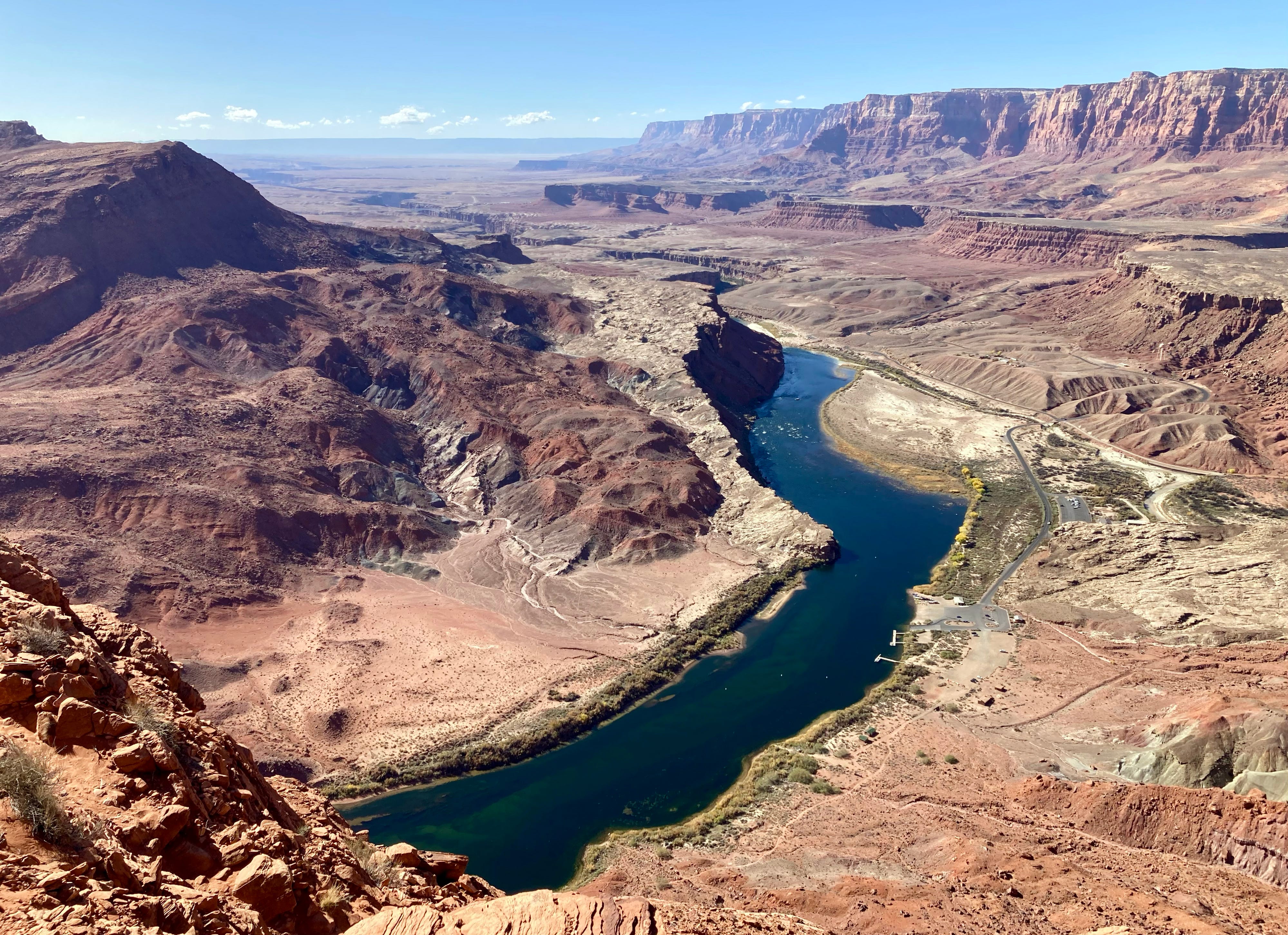
Recently, my colleagues at High Country News and I had a bit of a kerfuffle over whether the place on the Colorado River that divides the Upper Basin from the Lower Basin was called Lee Ferry, Lee’s Ferry, or Lees Ferry. Our esteemed copyeditor, Diane Sylvain, was beating herself up for letting a “Lee Ferry” sneak into an article I wrote, when the HCN style guide says it should be “Lees Ferry.”
I pointed out that it was fine, since “Lee Ferry” is an accepted spelling, as is “Lee’s Ferry.” This prompted a sharp rebuke: “Its name is Lees. … Dissenters can use apostrophes on their own time.”
Great. Now I’ve been labelled as a copyedit dissenter. That hurts. But it also sent me down a wormhole on this whole Lee Lees Lee’s Ferry thing, not in an effort to catch any copyeditors out, not as an act of dissent, but just because I’m curious about how we got to where “Lees Ferry” is the accepted spelling, in defiance of apostrophes and, perhaps, history. In the process I learned a lot about one of the coolest spots I know.
Honestly, I wish we could use a different name altogether for this place of convergence in the far reaches of northern Arizona, something grander and more suited to the landscape, to the condors that ply the skies over the Marble Canyon, to the towering Vermillion Cliffs, and the way the light plays off the stone and dances across the ripply waters of the Colorado River, a dim echo of the geological turmoil that occurred here. Lees Ferry is where the Wingate sandstone of Glen Canyon gives way to the Kaibab limestone of Marble Canyon, where the deep gorge of the Paria River meets up with the Colorado, and — more arbitrarily — where the Upper Basin of the Colorado River meets the Lower Basin.
The geologic transition influenced the topography, making this one of the few places in the region that people and their horses and wagons can reach the Colorado River safely without winches and ropes or parachutes.
Hopi people probably forged the first footpaths to the river from the east, making their way down the giant limestone ramp. Much later, the Escalante-Dominguez expedition of 1776, searching for a return route to Santa Fe, stumbled upon this place, naming it San Benito de Salsipuedes1. “The entire terrain from San Fructo up to here is very troublesome,” the friars wrote, “and altogether impassible when it contains a little moisture from snow and rain.” They also said the land was “pleasingly jumbled,” which seems a perfect descriptor. Some of the Spaniard colonists tried to cross the river, but found that the water was too deep and the current too swift — although they managed to survive. They had to exit the canyon and continue upstream for miles before finding a way across.

Paiute guide Naraguts led explorer Jacob Hamblin to the crossing in the 1860s, putting it, figuratively, on the Euro-American maps. And in 1871, a man named John Doyle Lee and his wife Emma settled near the mouth of the Paria and, with a boat abandoned by John Wesley Powell, established a ferry river crossing just upstream from the confluence of the Paria River, naming the place Lonely Dell.
Lee was the adopted son of Brigham Young and had been a Church of Latter Day Saints leader. However, the church excommunicated him after he helped lead the Mountain Meadows Massacre in southwestern Utah, which resulted in the killing of more than 100 non-Mormon white settlers. Whether he chose to go to the remote Lonely Dell to escape prosecution for mass-murder or was exiled there isn’t really clear. Either way, it didn’t work out: Federal marshals arrested him in 1874. In a jail-house interview with the Philadelphia Times the following year, Lee said he had 18 wives, 63 children, 100 grandchildren, and one great grandchild. He also refused to implicate Brigham Young for his role in the massacre. Lee was tried, convicted of first-degree murder, and executed by firing squad in 1877.
Emma Lee continued operations at the ferry until 1879 (meaning she ran it for longer than her husband). Then Warren Johnson and sons ran the enterprise on behalf of the LDS Church, followed by James Emmet and the Grand Canyon Cattle Co., followed again by Johnson and sons for Coconino County. The ferry was finally shut down in 1928 after an accident killed three people. The Navajo Bridge downstream was under construction at the time and would have displaced the ferry, so it would have been abandoned anyway.
John Lee’s notoriety and his conviction didn’t dissuade folks from using his name to refer to the ferry and the place — although it could be argued that it’s named after Emma, not John.
George F. Cram maps from 1879 and 1900 show “Lee’s Ferry” at the confluence of the Paria and the Colorado rivers, but an 1881 version of Cram’s map calls it “Lees Ferry.” Newspaper articles in 1899, 1905, and 1935 refer to the place as “Lee’s Ferry,” as does an 1884 Rand McNally map. It goes like this up until the 1930s, with mapmakers and others generally using both Lee’s and Lees, depending, perhaps, on the typesetter’s fondness for apostrophes. Another theory (albeit likely false): “Lees” is actually the plural form, not the possessive without the apostrophe, so as to give both Emma and John credit for starting and running the ferry. Whatever the case, by the 1940s “Lees Ferry” had edged out “Lee’s Ferry” as most cartographers’ preferred form.
It seems, then, that we have come to the end of this journey, and that “Lees Ferry” is the most acceptable spelling, whether or not it’s grammatically correct. But then along comes “Lee Ferry” to throw it all out of whack.
In 1916, Eric C. LaRue wrote a paper on “The Colorado River and its Utilization” for the U.S. Geological Survey, which is the arbiter of place names. In it, he refers to the place where the Paria River meets the Colorado River as “Lee Ferry.” Except then, five years later, the USGS installed a Colorado River streamflow gage just upstream of the Paria River confluence and called it “Lees Ferry.”
Does this settle it? Nope. Because in 1922, the Colorado River Compact was hammered out. This is the foundational document of the “Law of the River,” and it partitioned the Colorado River watershed into the Upper Basin and Lower Basin states and parceled out its waters to each. The dividing line between the two? Lee Ferry. No, the authors did not accidentally omit the “s” in “Lees.” In its definition-of-terms section, the Compact says: “The term ‘Lee Ferry’ means a point in the main stream of the Colorado River one mile below the mouth of the Paria River.” Yet, the ferry established by John and Emma Lee — along with the USGS streamflow gage — are located above the mouth of the Paria River (because sediment from the Paria can mess up measurements and, possibly, ferries).

While these two points on the map are close enough together to be considered the same place, there is a significant distinction when it comes to accounting for the water in the Colorado River: By putting the dividing point (Lee Ferry) below the mouth of the Paria, it includes the Paria River in the Upper Basin, and includes those flows in the 75 million acre-feet every ten years the Upper Basin is obligated to allow to flow past Lee Ferry. To determine the flow at Lee Ferry, the USGS adds the measurement from the Lees Ferry streamflow gage to the one from the Paria River gage.
It’s about as clear as a sediment-choked Colorado River now, isn’t it? Here it is in a slightly more concise version:
Lees Ferry = Lee’s Ferry ≠ Lee Ferry
Lees Ferry is the most widely accepted term for the geographical location at and around the confluence of the Colorado River and Paria River in northern Arizona. It’s probably derived from “Lee’s Ferry,” as the USGS typically drops apostrophes from possessive place names for reasons unknown. Lees Ferry also refers to the USGS Colorado River streamflow gage located just upstream from the mouth of the Paria River.
Lee Ferry is the correct term for the point one mile downstream from the mouth2 of the Paria River that divides the Colorado River’s Upper Basin from the Lower Basin. The Colorado River Compact mandates that the Upper Basin “will not cause the flow of the river at Lee Ferry to be depleted below an aggregate of 75,000,000 acre-feet for any period of ten consecutive years.”
The streamflow at Lee Ferry is determined by adding the measured flow at the Lees Ferry streamflow gage to that at the Paria River gage just upstream from the Paria River’s mouth.
So, if one is writing about the Upper Basin’s non-depletion obligation, they should use “Lee Ferry.” If they are writing about the historical settlement, the general place, or the streamflow gage, they should write "Lees Ferry.”
🌵 Public Lands 🌲
THE NEWS: MAGA Sen. Mike Lee, of Utah, is back on his anti-public-lands crusade, this time with an underhanded attempt to repeal the wildly popular 2001 Roadless Area Conservation Rule, which protects some 45 million acres of U.S. Forest Service land from roadbuilding and logging3. And yes, Mike Lee is related to the aforementioned convicted mass murderer John D. Lee, though I’m sure that has nothing to do with this.
THE CONTEXT: Lee had a busy week. First, he went ballistic on social media after the Trump Defense Department removed the Church of Latter Day Saints from its list of Christian religious denominations (it’s still a recognized faith, but lost the “Christian” label). Apparently he was worried Mormons would be left out of Pete Hegseth’s white Christian Nationalist holy wars.
Then, ol’ Jell-O-Social Lee snuck a last-minute amendment into the bipartisan Wildfire Prevention Act that would not only kill the Roadless Rule, but also prevent a similar rule from being implemented later. The Senate’s energy and natural resources committee voted to advance the amended legislation along party lines. Next it will be subject to a full Senate vote.
Lee’s amendment “just blows up” the bipartisan support for the larger Wildfire Prevention Act, said a clearly dismayed Sen. Martin Heinrich, a New Mexico Democrat. The larger legislation, introduced by Sen. John Barrasso, R-Wyo., aims to increase forest thinning and other vegetation treatments as well as prescribed burns on Forest Service and BLM land. It would also guide the agencies to develop strategies for using “livestock grazing as a wildlife risk reduction tool.”
The jury is certainly still out on the efficacy of forest thinning as a wildfire hazard mitigation method. As for livestock grazing? Yeah, probably not, unless all vegetation is eaten down to bare dirt. And once all of the native grasses are gone, it opens the door to cheatgrass, which is especially flammable. Then there’s the question of whether wildfires are really a bad thing — but we’ll leave that debate for later.
Lee claims his motives are pure, and that the Roadless Rule is hampering access for fire prevention and fighting efforts. That’s not true. While the rule generally prohibits roadbuilding and timber harvesting in inventoried roadless areas, it makes exceptions for both if they are deemed necessary for wildfire hazard mitigation or to fight fires. In a public hearing, Sen. Alex Padilla, D-California, pointed out that 240,000 acres of inventoried roadless areas in his state alone had been treated for wildfire hazard mitigation treatment, proving Lee wrong. And the Trump administration, for better or worse, has lagged on forest thinning: A Center for Western Priorities analysis found the Forest Service treated 35% less acreage in 2025 than it did under Biden in 2024.
In fact, building more roads increases access to remote areas. Since most fires are started by humans, it follows that putting more humans into a forest makes it more likely that forest is going to be ignited by an errant spark, cigarette, campfire, or a hot catalytic converter in some tinder-dry grass. So if you really want to prevent wildfires, consider closing some of the thousands of miles of existing roads across public lands.
It’s not clear what Lee hopes to accomplish with these inane, and often futile moves, but what he has done is given strength and energy to the environmental movement. His bid last year to sell off public lands to real estate developers not only flopped, but enlarged the constituency opposing land transfers of any kind. His latest assault on public lands has riled up the hook and bullet crowd, who don’t want roads and timber operations sullying game habitat and streams. And his amendment may very well kill the wildfire bill’s chances at passing, disrupting the efforts of his right-wing colleagues.
Maybe Lee’s inherent extremism forces him to lash out at bipartisanship and pragmatism, in general. After all, he got into the Senate by unseating the late Sen. Bob Bennett, a conservative Republican who lost favor with the more extreme wing of his state’s party by attempting to broker a compromise on public lands in Utah.
It’s tempting to blame Lee’s zealotry on genetics, given that he is the great-great-grandson of John D. Lee, who was convicted and executed for his role in the Mountain Meadows Massacre of 1857, when a group of Mormon militia members killed about 120 gentile emigrants as their wagon train made its way from Arkansas to California. The attack came during a time of heightened tension and conflict between the LDS church and the federal government.
The problem with that theory is that John D. Lee’s direct descendants — who likely number in the thousands by now — also include Stewart and Morris Udall, influential Western Democratic politicians and public lands champions. Stewart served as Interior Secretary under John F. Kennedy and Lyndon B. Johnson, and Morris was an Arizona congressman for three decades. Stewart’s son Tom represented New Mexico in the House and Senate, and Mo’s son Mark, a Colorado Democrat, served in the Senate and House as well.
Those Udalls were (and are) Democrats and environmentalists and, according to some takes, “staunch liberals.” But they were also old-school Western politicians who valued pragmatism over ideology and values over party, everything Mike Lee is not. Lee could learn a lot from his kin.
🛢️ Hydrocarbon Hoedown 📈
I’ve written here often about how the Trump administration is handing out drilling permits to petroleum companies like Shriners throwing candy at a parade. Over the last six months, for example, the BLM has issued drilling permits at a rate of 500 per month; you’d have to go back to the George W. Bush administration to see the agency acting at a more rapid pace. But the administration is supplicating itself even more to the fossil fuel industries in a different realm: leasing as much public land to oil and gas companies as they possibly can.
Earlier this month, for example, the Bureau of Land Management auctioned 114,439 acres of public land in Wyoming to the oil and gas industry. Next week, the BLM will put a whopping 160,268 acres in Colorado on the auction block, which could open 174 parcels in Arapahoe, Garfield, Jackson, Mesa, Moffat, Rio Blanco, Routt, and Weld counties — including prime elk habitat — to drilling. And in December, the agency is looking to auction nearly 79,000 acres on the Arizona Strip, despite the fact that there are no known petroleum reserves there.
The public comment period is long gone for those lands, but another planned December sale in Colorado is still subject to your input. This time the BLM is looking to sell 114 parcels on nearly 127,000 acres. The parcels are scattered around the state, with the biggest chunk east of Trinidad, including a block along the Purgatoire River. More than 2,000 acres in and around the HD Mountains in southwestern Colorado — including one big swath south of Chimney Rock — are also going on the block.

I’ve seen different translations for “Salsipuede,” including: “you can get out” and “get out if you can.” It seems that the latter is most accurate, given that a “San Benito” is a cassock worn by errant friars. They also called the place “distressful.”
This is not at a fixed point, as the mouth of the Paria River has migrated from north to south over the years, thanks to sedimentation and so forth.
The original rule covered nearly 60 million acres, however, as the rule was battered around the courts and political playing field in the years after its implementation, Colorado and Idaho petitioned to create state-specific rules for inventoried roadless areas in their states. That means that any rescission of the rule, whether it’s administratively by the Trump administration or via Lee’s amendment, would not affect Colorado or Idaho roadless areas.


