🥵 Aridification Watch 🐫
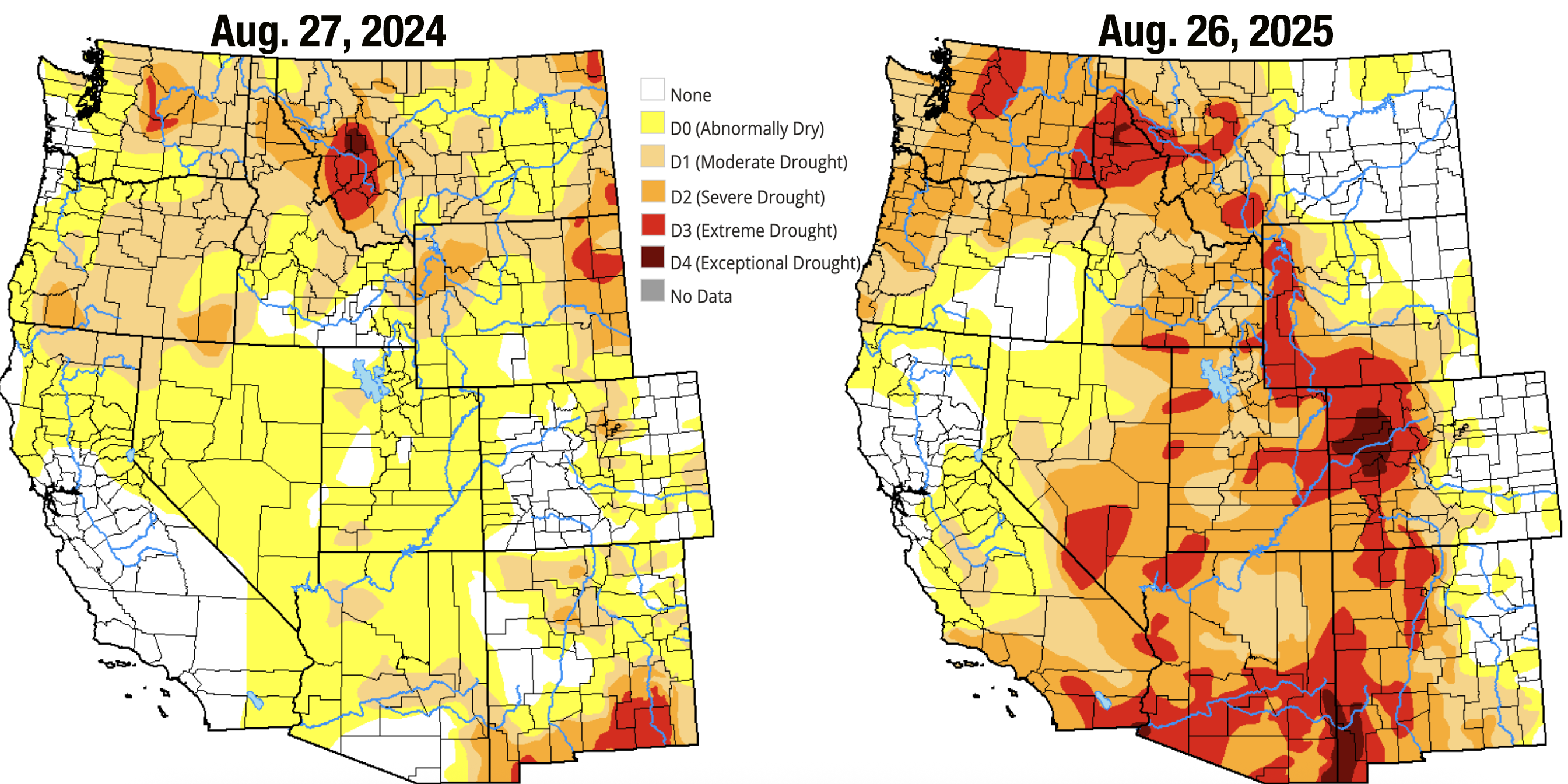
Summer’s officially over. Meteorological summer, that is. And damn what a dry and hot and smoky summer it was. It wasn’t one of those summers with superlative maximum temps: The mercury in Death Valley only climbed to 124 on a couple of occasions this summer, for example, far off the record high. But in most places the average temperatures for the months of July and August were far higher than normal.

Meanwhile, almost everywhere in the West was cursed with below normal precipitation. The monsoon was late, and when it finally did arrive, it was a dud. At least it has been so far. Not only were rainfall amounts lower than usual, but the soil was so dry that it sucked up a lot of the moisture before it reached the rivers. That has meant that the typical August streamflow jumps never really materialized, especially in the Colorado River Basin. The fish aren’t doing so well. Heather Sackett of Aspen Journalism reports that the Crystal River, along with the rest of the Roaring Fork, Gunnison, and White/Yampa River Basins are hurting, prompting officials to institute voluntary fishing and floating closures.
About 82% of the West is in drought, with about 47% suffering from severe to exceptional drought. The hardest hit areas include northwestern Colorado and southwestern Wyoming (aka the Colorado River headwaters), southeastern Arizona and southwestern New Mexico, and the Idaho panhandle.
The combination of factors has resulted in low inflows into and steep declines in water storage in Lake Powell. The reservoir — which is both a barometer of the Colorado River’s health and the Upper Basin’s savings account — is now at about the same level as it was in early September of 2021. It both complicates and adds urgency to negotiations over how to split up the Colorado River in a warmer, dryer world.
Let’s look at some graphics:

These hydrographs for the Animas River in Durango, the Chaco River just above its confluence with the San Juan, and the Rio Grande through Albuquerque, show that the monsoon did, in fact, arrive, albeit dreadfully late and bringing nothing but chips and cheap bean dip (a potluck metaphor, by the way). The Chaco River ballooned from bone dry to raging river (off the charts!) in a matter of hours, but was nothing but a muddy trickle a couple days later. The Animas also got a boost, but nothing close to as big as it normally gets this time of year. For once, the Rio Grande looks the best, with flows jumping from zero to about 300 cfs, before plateauing around 120 cfs for several days now.


Of course, these charts could turn around at any time. The monsoon may just be getting started, and will end up bringing steady, autumn rain and sustained higher streamflows with it. The biggest floods of the region have typically come in September and October, usually as tropical storms make their way inland and dump their load on the Interior West, think Oct. 1911 or Sept. 1970. That could happen again.
Even multiple deluges won’t reverse the Lake Powell deficit that’s built up this year, however. This water year’s actual inflows into the reservoir have been below normal for nearly every month, and were especially low in August. But more alarming are the unregulated inflows, which are an estimate of how much water would be flowing into the reservoir if there were no diversions or reservoirs upstream. This can look a bit weird, since in some months the estimate is a negative number.


Hi I just spent a week at 30 Mile campground at Rio Grande reservoir. It did rain several of the days so maybe a late monsoon? Driving up to Lake City was somewhat depressing because it looks like even the aspen are dying in places. My question is- how does this reservoir control the water downstream? Also saw some guys working on the "Snotel" and they talked about studying why, as they said, snow is disappearing. Thanks!
Oddly we had the coolest summer in eight years up here at the lookout. We never got above 78*.F The ambient smoke haze has been the worst with poor views of Shiprock, Comb Ridge, and Monument Valley. I only have my 2024 and current journal up here to compare. Last year's precip to date was a whopping 5.5 inches and this year is 2.8 inches. A fair gap in moisture. We lost our wildflowers in late June when typically they would hold up until now.