

PART I
The manila envelope arrived in the mail last summer, containing a long-tabloid-sized document on aged, brittle newsprint. The washed out cover photo was black and white, but it was framed by a thick blue square. Sunday, August 15, 1971, it said on the top right hand corner, then: DURANGO! Shaping An Urban Area above the old school Durango Herald flag.
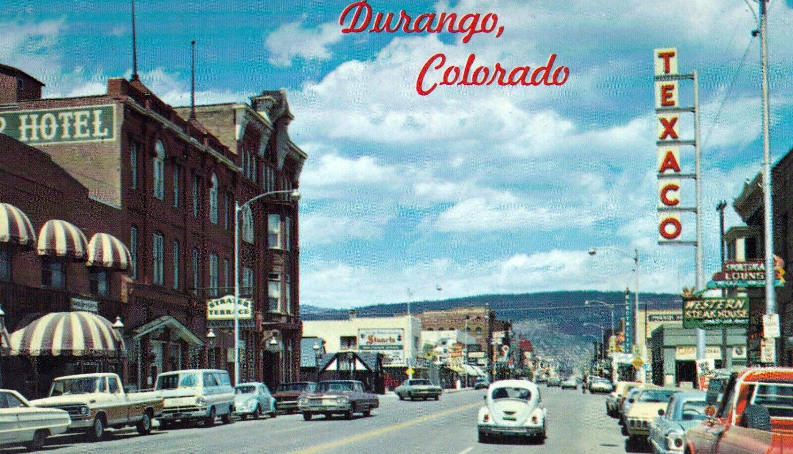
It was accompanied by a handwritten note from Richard Ballantine, the Chairman of Ballantine Communications, the Herald’s parent company. He had excavated it from the depths of his desk-pile (if you’ve seen Richard’s desk, you know what I mean) and thought I’d be interested, in part because the document—the Durango-area comprehensive plan—was compiled and edited by my father, but also because of the window it offers into my hometown’s history.
At first it seemed a bit quaint, a relic from a simpler time, when folks in Durango—and dozens of other similar communities across the Western U.S.—couldn’t even imagine the sorts of challenges their town would be facing half a century later. Then I started reading and realized I was wrong. The “planners” of the time, a group of local volunteers, anticipated the hurdles to come with remarkable foresight, and the goals they set shaped Durango into what it is today—for better and at times for worse.
Durango was established in 1880 as a supply town and the mercantile and professional hub of the area’s mining camps. During the community’s first several decades, coal mines dotted the surrounding ridges, a massive smelter on the south edge of town processed concentrates from the Silverton-area mines, nearby farms and ranches fed the mining camps, and rail lines stretched out of town to the north, west, south, and east. During World War II the smelter was converted into a uranium mill that supplied the Manhattan project.
In the 1960s, however, many of Durango’s extractive-industry roots had begun to wither. The uranium mill shut down in 1963 after locals figured out it was contaminating the Animas River and the Southside’s air with radioactive materials. Trucks and highways displaced rail transportation, and by 1970 all of the rail lines out of Durango except the Silverton segment had been abandoned. Only one Silverton mine, the Sunnyside, continued to churn out significant amounts of ore. The San Juan Basin just south of Durango was home to a major natural gas drilling boom, but Farmington became the hub of most activity, not Durango.
That left Durango with tourism and—though the coin wasn’t yet in common parlance—the amenities economy. If it couldn’t make it from extracting minerals from the hills, it would have to bank on the scenery, history (real and imagined), and elusive “quality of life.” To this end Denver oil man Ray Duncan established Purgatory Ski Area in 1965. The Durango-Silverton train became a tourist attraction and a major character in various Western films, from Ticket to Tomahawk, to Rio Grande, to Butch Cassidy and the Sundance Kid. And the Animas Regional Planning Commission, of which my grandfather was a member, set out to guide inevitable change to result in a community, “which will become progressively more fulfilling and livable for all of us.”
The challenge we face is whether or not as a group of 12,000 we will let that change shape us or whether we will shape the change. … Durango is a series of communities: labor, education, retirement, agricultural, professional, service, youth, educated, uneducated, Chicano, Anglo, poor, middle income … and among many of these sub-communities there is almost no communication, no feelings of concern for the other. It is this fragmentation that makes us very much “urban” in the modern American sense. We are not a small town.
I could go on, but I’ll have mercy on you all. What is it about the used-to-be game that’s so appealing? Is it just nostalgia? A reminder of how much things have changed? A reminder of how old we really are? Whatever it is, if you enjoy it as much as I do, please go ahead and throw your favorite “used-to-bes,” from Durango or elsewhere, into the comment section.
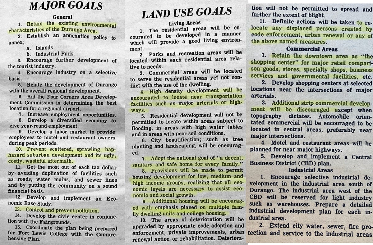
The planners hoped to retain the community’s assets and fix its weaknesses. Their major and land-use goals include (highlights mine). If it’s fuzzy, go to LandDesk.org to view in hi res:
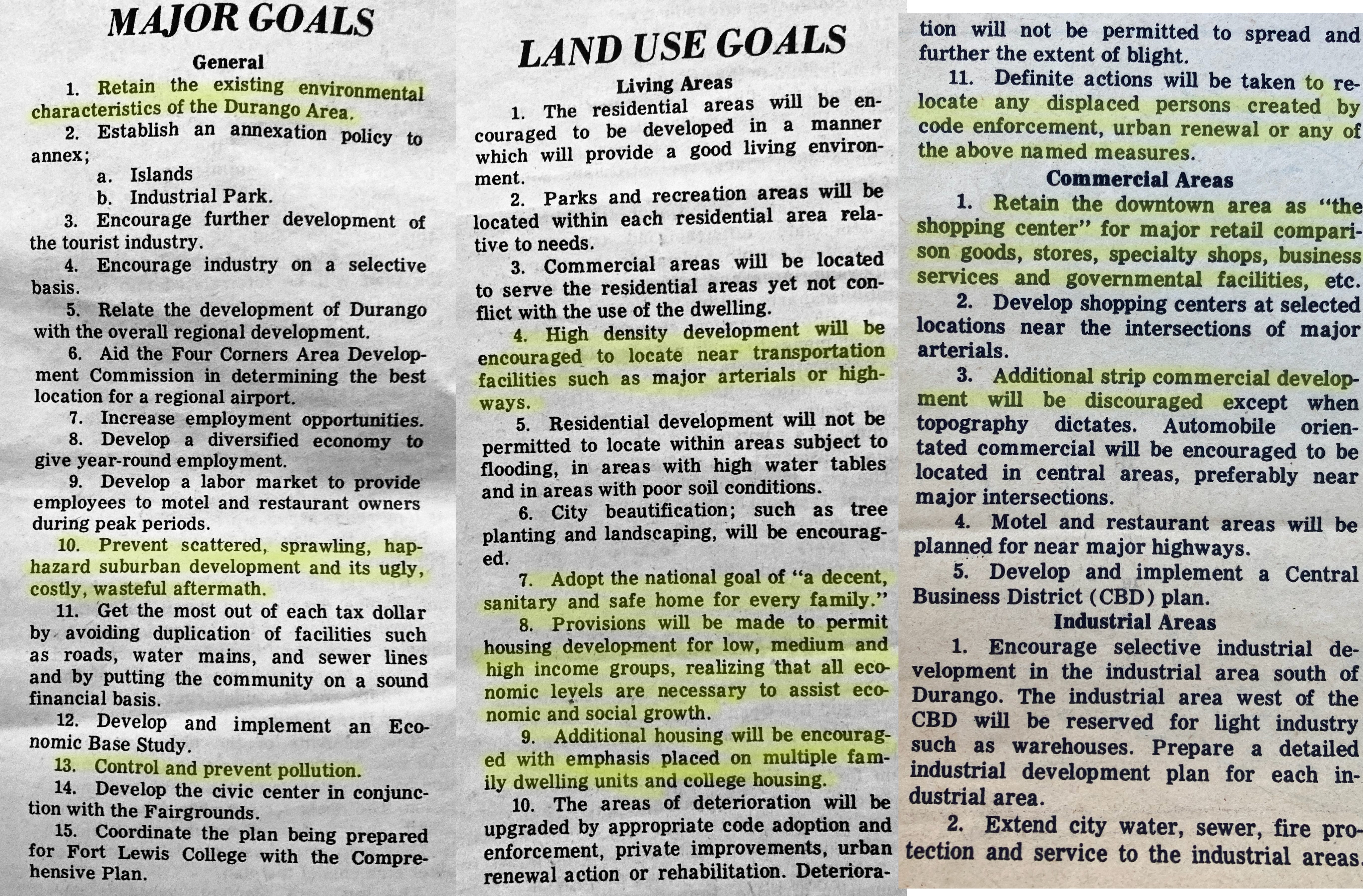
Wow, these guys (yes, all of the planning commission members were men and all but one were white) used some pretty strong—and, in my opinion, accurate—language regarding suburban development and wanted to limit strip malls. In America, no less! They also clearly stated the necessity of providing housing to everyone because “all economic levels are necessary to assist economic and social growth.” Damned good point.
They also were fired up about establishing greenbelts, open space, parks, and other areas for recreation. So for all those folks who try to say that bike paths and recreation are imposed upon Durango from the outside are, well, wrong.
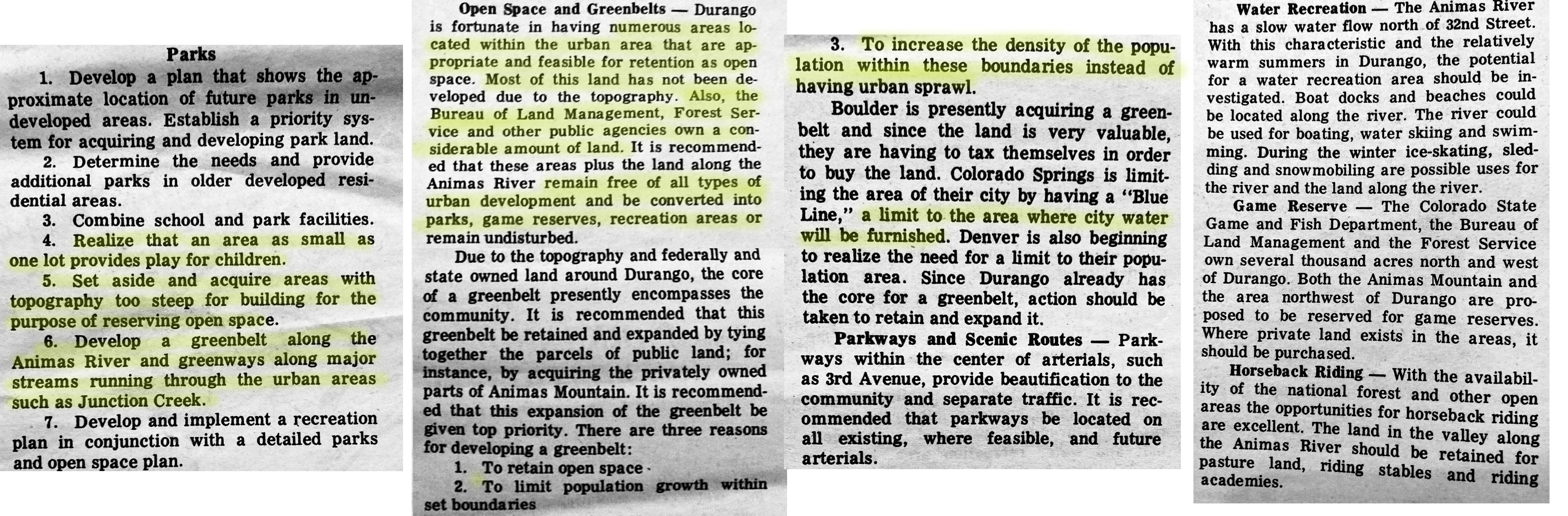
The planners planned to guide growth and development via subdivision regulations, zoning, land-use and building codes, and—see above—by acquiring and establishing green spaces to “limit population growth within set boundaries” and “increase the density of the population within these boundaries instead of having urban sprawl.”
PART II
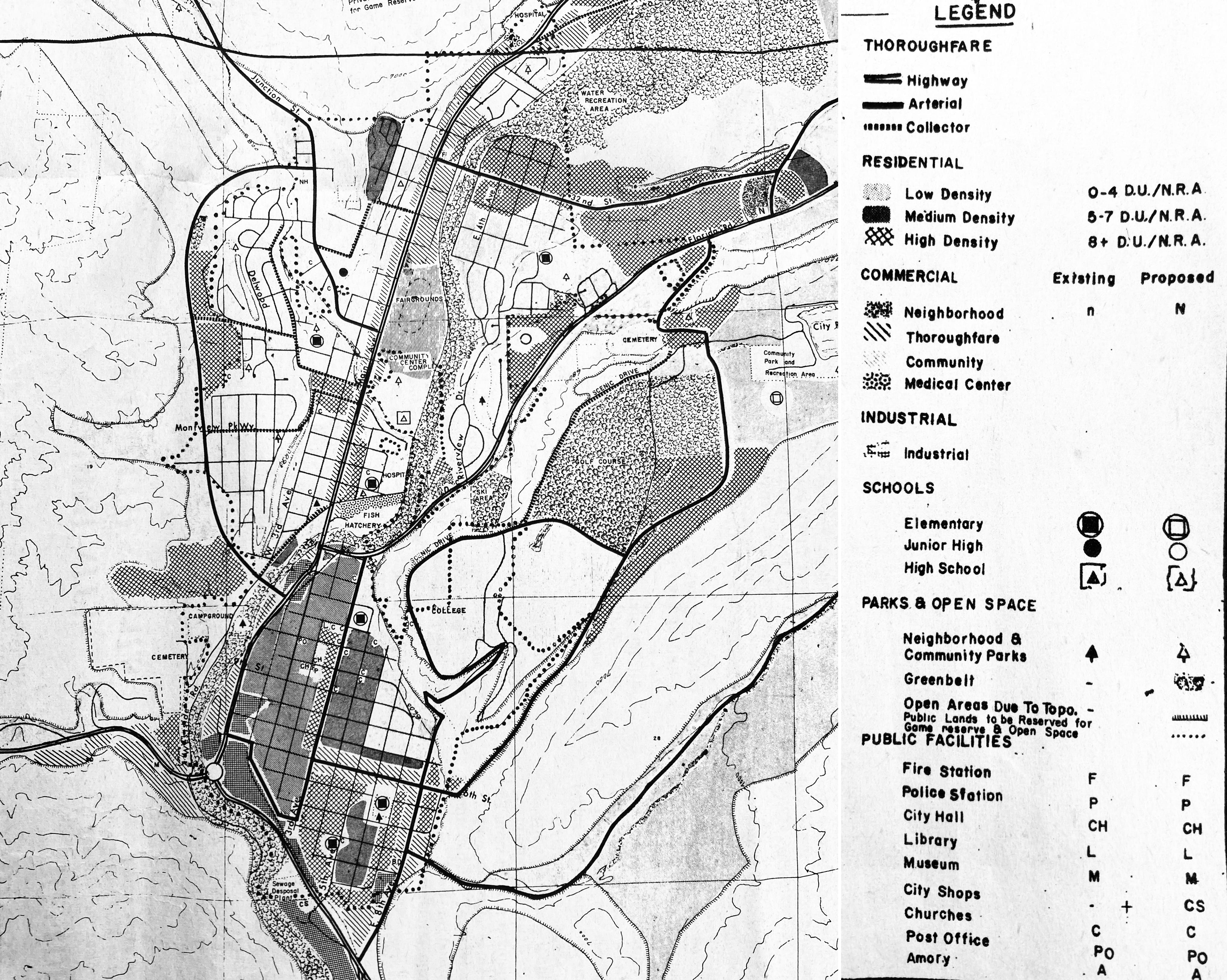
In 1971 a group of local Durango leaders issued what I imagine is the town’s first ever comprehensive land use plan—aside from the original 1880 plat. They acknowledged that the town was changing and would continue to change, perhaps radically, as it transitioned away from a semi-industrial hub for mining, ranching, and logging towns toward something new. They knew they couldn’t control growth, but did feel they could have a hand in guiding it, and the plan they published as a special supplement to the Durango Herald was a sort of road map for local officials and residents to follow.
The planners’ goals were ambitious but reasonable: limit sprawl, establish greenbelts along river corridors and open space along the town’s boundaries, further develop the tourism industry, develop a diversified, year-round economy, and provide decent housing for everyone. They also had a list of more specific targets for infrastructure buildout.
More than fifty years have passed and Durango clearly has changed and grown in ways the planners probably couldn’t have imagined. Yet their efforts and the resulting plan were remarkably prescient, and foresaw much of what would come. But did it work? Have we (i.e. Durango’s residents and leaders of the last half century) successfully followed the map? Or have we gone astray?
Let’s ponder each major category of goals.
Limiting suburban sprawl and retaining the community’s environmental character: This one’s a bit of a mixed bag. Google “suburban sprawl” and you’re not likely to come up with an image of Durango. Sprawl’s definition is somewhat squishy and subjective, but when we talk about sprawl we’re usually referring to low-density, single-family, car-oriented development. Durango’s core rates fairly low on the sprawl scale, especially when compared to, say, Farmington or Grand Junction. There is generally a decent mix of single-family and multi-family housing (although it’s not always distributed very well) and most parts of town are fairly pedestrian friendly.
Of course, this breaks down as one ventures away from the early town boundaries. The Bodo area, which was established as an industrial park in the ‘70s but evolved into a mixed-use zone, is a disjointed, sprawling hodgepodge of I don’t-know-what, as is the Walmart/Home Depot area south of there. So much for retaining “the downtown as the ‘shopping center’” and discouraging “additional strip commercial development.”
Durango’s relative lack of suburban sprawl likely is a result both of planning and topography—there’s just not a lot of flat, sprawl-ready ground in the town’s immediate surroundings. That has pushed suburban sprawl out into the former agricultural areas, such as the Animas Valley north of town and out on Florida Mesa (where it takes the form of ranchette-rural sprawl).
I’m giving us a 6 on this one.
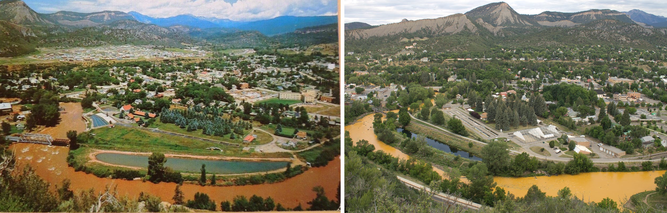
Greenbelts and open space: In Durango’s early days, the banks of the Animas River were the designated industrial zone, and the waters were industry’s dumping ground. The mines and mills of the Silverton area sullied the waters with fish-killing acid mine drainage and tailings, then Durango’s slaughterhouses and sawmills and the smelter and, after that, the uranium mill, added to the yellow-gray soup with their own melange of pollution. By the time the river crossed into New Mexico it was a toxic soup with a current. In 1971, the situation hadn’t improved that much. Tailings spills into the river were fairly common and in Durango the leftovers of industry still lined the river’s banks in many places.
So it’s pretty amazing that the planners of the time were able to envision something far better, and even more incredible that those visions have been realized and then some. The Animas River is the town’s green, scoliotic spine as well as its heart and soul, and the River Trail provides a car-free artery from one end of town to the other. That Durangoans have access to so much of the river’s shore almost makes the astronomical housing prices worth it. Nearly as important are the open spaces around town, from Horse Gulch, to the Test Trax (Overend Mountain Park), to the trails on College Hill and Animas Mountain.
There are a few 1971 greenbelt goals that have yet to be achieved, however. Junction Creek also was supposed to have a greenbelt and trail along it (imagine taking that from town all the way up to the Colorado Trail?). Didn’t happen. The plan calls for converting Turtle Lake and City Reservoir (on College Hill) into public parks. Nope. And the 1971 planners also wanted to make the Animas River north of town into a recreational mecca (with water skiing and ice skating!). While the extension of the Animas River Trail park and of the greenbelt up through Oxbow Park is a beginning, the grander vision never came to fruition and the river banks through the Animas Valley are off-limits to public access.
This one gets a solid 9.
Housing: The 1971 plan devotes a lot of column inches to the topic of housing, but fails to anticipate the affordability crisis in which the community, and much of the nation, now finds itself. Back then the planners in Durango and elsewhere mostly were focused on “blight,” the proliferation of substandard housing, and “urban renewal.” This sort of “renewal” often entailed tearing down historical housing (often in lower-income areas and communities of color) and mixed-use structures and replacing them with parking lots, highways, or crappy high-rises. A good portion of Denver’s downtown neighborhoods fell victim to the urban renewal wrecking ball in the ‘60s, which converted a vibrant, human-friendly, walkable, mixed-use area into a quilt of parking lots (only to see it all built back four decades later into a modern, gentrified replica of the destroyed neighborhoods).
In Durango, it was the entire Santa Rita neighborhood, the residents of which were predominantly Latino, that was scraped to make way for a (sorely needed) sewage treatment plant. I see this as a glaring lack of foresight on planners’ and leaders’ part. Santa Rita was a neighborhood in the classic sense, a community, and it was erased virtually overnight, taking a significant stock of housing away from the town forever. And though it may have seemed logical to site the treatment plant at what then was the edge of town, planners should have known that the community would grow southward, eventually wrapping around the plant. Hindsight’s 20-20, I know, but a much more appropriate location would have been at the county yard/Sale Barn area south of Home Depot.
The planners of yore endeavored to “make provisions” to “permit housing for low, medium, and high income groups.” What they didn’t realize is that one day it would take a lot more than to simply allow developers to put up affordable housing. Planners and leaders would have to require it and subsidize it. This is one area where planning in Durango and just about everywhere has failed: Instead of planning ahead, and purchasing land and housing for affordable units when prices were still somewhat reasonable, most communities are reacting to exorbitant housing prices and trying to play catch up. That means forking out millions to buy or build a handful of affordable units when hundreds of them are needed.
I’m going with a 7.
Development of the tourism economy and increase year-round employment: Umm, yeah, I’d say we overdid it on the tourism economy. And like many other communities, Durango appears to have staffing shortages, even in the winter. So, success, I guess?
This gets a 12 out of 10 for accomplishing the goals—no matter how questionable they may now seem.
Infrastructure, streets, public facilities: These are more specific goals in the plan, some of which seem downright odd in retrospect. For example, planners wanted to build an automobile bridge across the Animas River at 14th Street, right next to the existing Swinging Footbridge. It thankfully ended up five blocks downstream, at 9th Street, instead. They wanted to make the Horse Gulch road into a major traffic artery, which would have facilitated development in what is now an open space, recreational gem. They also wanted an arterial road to link County Road 203 (West Animas) with the Falls Creek Road near Turtle Lake.
And, apropos to current debates re the location of the main fire station: In 1971 Durango’s only fire station—which housed 10 firefighters—was located at 10th St. and 2nd Ave. Planners wanted two more stations, one south of town and one on the northeast corner of 32nd St. and Main Ave., which at the time was owned by the city. The fire department established its own special district and has grown considerably since then (and the Durango department merged with surrounding, rural, volunteer departments), establishing stations on the south end of town, on the north end of town—albeit not in the planned location—and outside of town. It also moved its main station adjacent to the old power plant. Now the department plans to move into the old high school and current school district administration building in a residential area, but also just down the street from its 1971 location. This has triggered a brouhaha of near-epic proportions.
I’d give this one a 7.
PART III
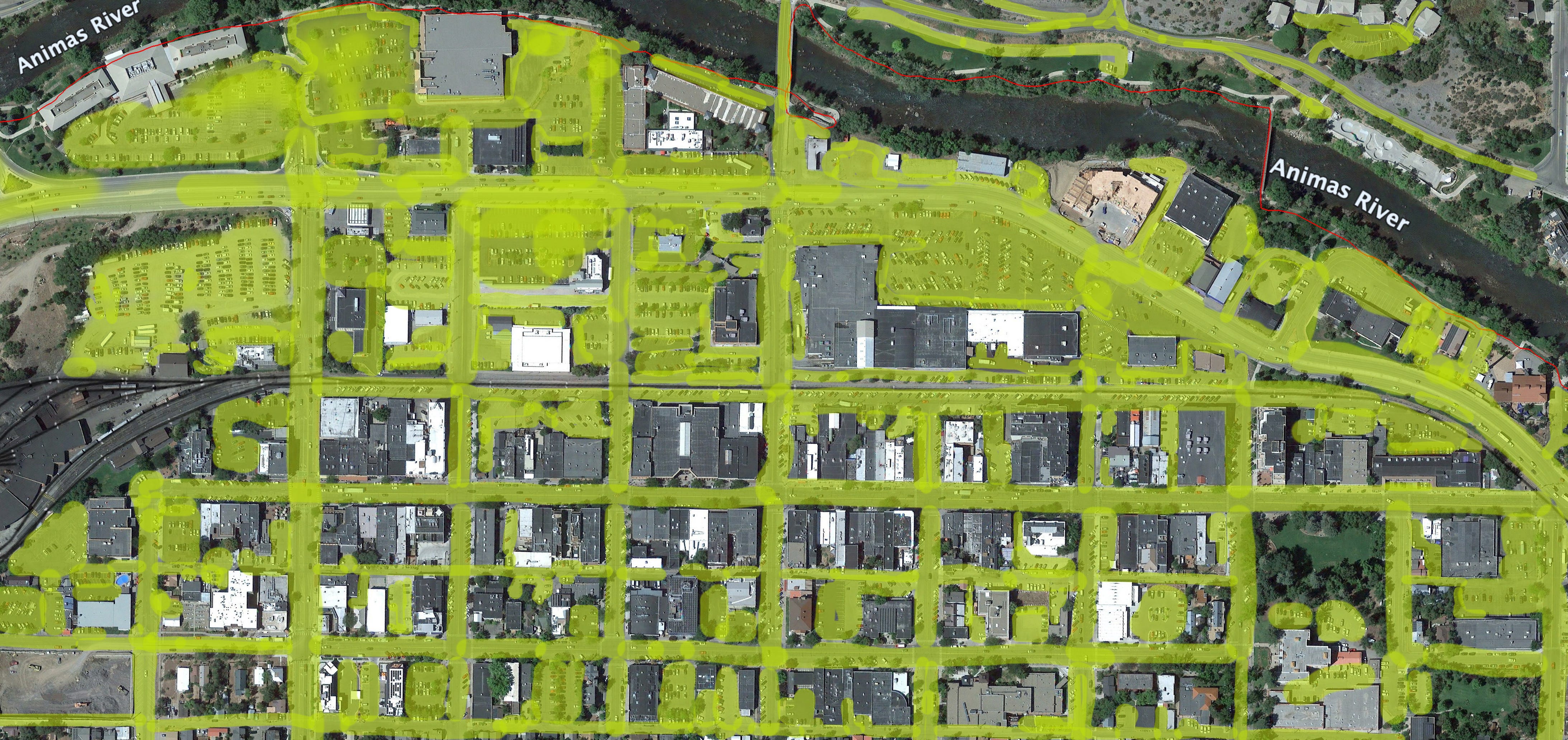
The above photo shows downtown Durango, Colorado, as seen from a Google Earth satellite in September 2019. And no, someone didn’t paint the streets yellow in real life, I colored them with photo-editing software. I started out doing it as an exercise for my own purposes. I wanted to see how much of the city’s commercial core was devoted to automobiles, highlighting those areas with yellow. I started with the streets, then moved onto the parking lots, then the alleys. Every time I thought I was finished, I’d encounter another rectangle of asphalt.
Ugly, isn’t it? It’s like a big, yellow-green, pus-oozing parking lot rash defiling the community. But it can also be a useful tool, one to keep on hand to whip out next time someone says there’s a parking-space shortage in downtown Durango. There’s not. Obviously.
Durango’s not alone in dealing with this automobile-centric affliction. Many cities are far worse. Still, it’s one of many problems that need solving.
We’ve looked back at what Durango was, and what some of its leaders wanted it to be, and what it became. Now it’s time for us wannabe planners to envision the future we want—just like the planners of 1971 did.
And the future the Land Desk Planning Commission desires is a Durango that is sustainable and livable for all. And not just environmental sustainability, but also human and economic and community sustainability. It’s our belief that Durango—and many, many communities in the Western U.S.—are moving rapidly away from any semblance of this sort of sustainability. They increasingly are becoming traffic-jammed enclaves for the wealthy and the vacationers and the upper echelons of the Zoom class, places that squeeze out the teachers and firefighters and food service workers and all the others who keep the gears of society grinding along.
It would be bad enough if the influx of wealth was accompanied by a corresponding uptick in the quality of life for those who could afford to stay. But that is hardly the case. If Durango was “urban” a half century ago, shouldn’t it be more urban now? In the 1971 planning document my father wrote:
The challenge we face is whether or not as a group of 12,000 we will let that change shape us or whether we will shape the change. … Durango is a series of communities: labor, education, retirement, agricultural, professional, service, youth, educated, uneducated, Chicano, Anglo, poor, middle income … and among many of these sub-communities there is almost no communication, no feelings of concern for the other. It is this fragmentation that makes us very much “urban” in the modern American sense. We are not a small town.
Durango’s population has nearly doubled since then and La Plata County’s shot up from 19,199 in 1970 (the same as in 1960) to 55,638 in 2020. And I think it’s safe to say that Durango has also progressed as a community in many ways, partly as a result of growth, itself, partly thanks to good planning and leadership. But over the last decade or so, the growth and wealth-influx has continued at a rapid pace, while progress in other realms slowed. Growth has not brought with it the trappings normally associated with urban places, be it robust public transportation, diversity, good jobs, or more opportunities. The “series of communities” of 1971 have, if anything, diminished in number and diversity, while still remaining as fragmented as ever. Mobility, the ability to get from one place to another by car, bike, or on foot, is decreasing, and the roads are becoming more dangerous. The arts and culture and food scene isn’t exactly exploding with vibrance. The town can’t—or maybe just won’t—sustain a daily print newspaper anymore, which has further diminished the community as a whole.
I’m no urban planner. And I know that real planners—really smart ones—are working on these complex issues, none of which have easy solutions. I’m not trying to tell anyone how to do their jobs. In fact, everything I suggest here would fit within the objectives of Durango’s current comprehensive plan. This is just a wish list from someone who grew up in Durango and cares about what it becomes, someone who has been covering these issues for many years, and someone who has gleaned a few ideas from far-flung communities in which I’ve lived. I’m not anti-growth or outsider, per se: When I was a teenager I yearned for a population-influx because I figured it would make the place more interesting. What I didn’t understand is that making a place “interesting,” whatever that might mean, takes effort, not just more people.
So with that great big caveat, here we go. I had intended to tackle all of the issues in just one dispatch, but soon realized that there’s too much. So this post will focus on mobility.
When I was growing up in Durango, my parents weren’t really the type to drive me around, and even when they offered I usually turned them down because I was embarrassed to be seen climbing out of one of our crappy old cars. But that was okay, because it was a fairly easy town to get around in on foot or by bike and even by bus—the transit system in the eighties was at least as robust as it is now, and there was even a town bus to Purgatory. You could ride a bike up and down Main Avenue without fearing for your life and, later, as a teen in the ‘80s, I felt totally safe riding on even the major highways in and out of town.
Since then, Durango has become famous as a nurturer of world-class cyclists, but at the same time cycling—and walking—have become more and more perilous (I pretty much gave up road riding because of multiple near-death encounters with car-driving a**holes). True, the best planning in the world won’t do anything about the a**holes, but good planning could ease traffic and good infrastructure could better protect bikers and pedestrians from the a**holes. More than that, orienting the community toward human beings rather than toward automobiles—as it is now—will make life better for all the human beings, even the a**holes who wield their four-wheeled monstrosities like weapons in some fossil-fueled culture war.
Overhaul Main Avenue: Once upon a time (used-to-be game alert), Main Avenue was a major thoroughfare for its entire length. If you were at 1.________ Hospital on the north end of town, and wanted to get a steak dinner at the 2.________ (located on the outside of the big bend on 160/550 just before 3.________ Hill), you’d drive all the way down Main, turn left on 6th Street (College Drive), and then right on 8th Ave., pass the bus station, the Villa restaurant, the sawmill, the 4. _______ Drive-in, and the 5. ________ Barn before arriving at your destination.
Now most of those places are gone and Main Ave. is no longer a primary artery through town. So why does it still look like a highway? It has six lanes for cars (four for driving, two for parallel parking). Six lanes(!)—for a road that really doesn’t need to have cars on it at all. But no, we’re not advocating for a pedestrian-only mall—those tend to gentrify. We’re simply calling for a “complete streets” makeover for downtown Durango, which is to say it should be oriented towards humans, not cars.
Cut Main Ave. down to two lanes for driving, widen the sidewalks, make the COVID-era bumpouts permanent, with cutouts for some diagonal parking. And put roundabouts at 6th, 9th, and 12th Streets. If Grand Junction and Farmington can do it then so can Durango.
In other words, we could make this:
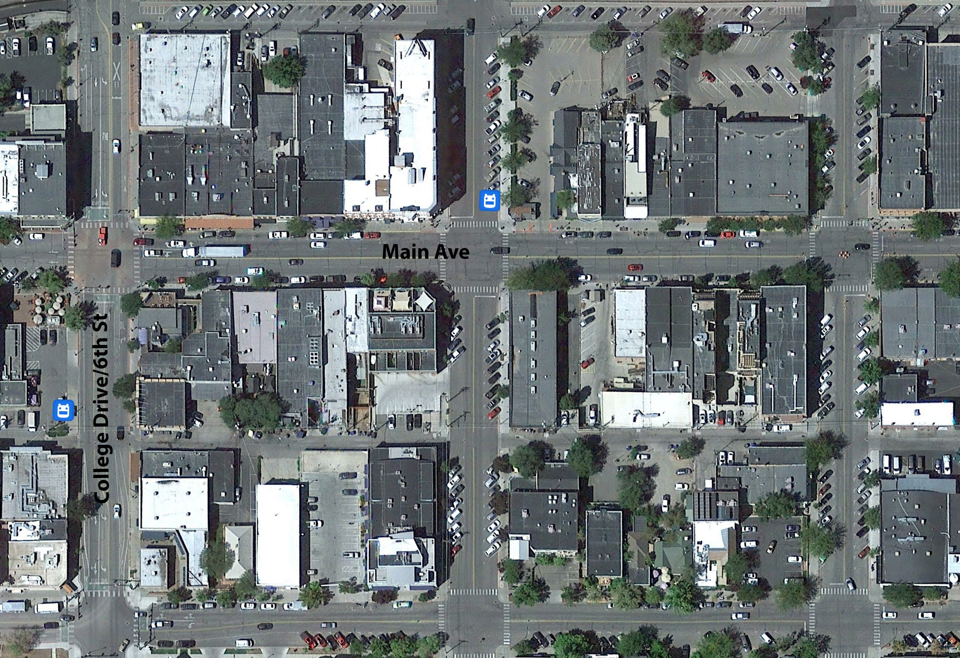
Into something like this:
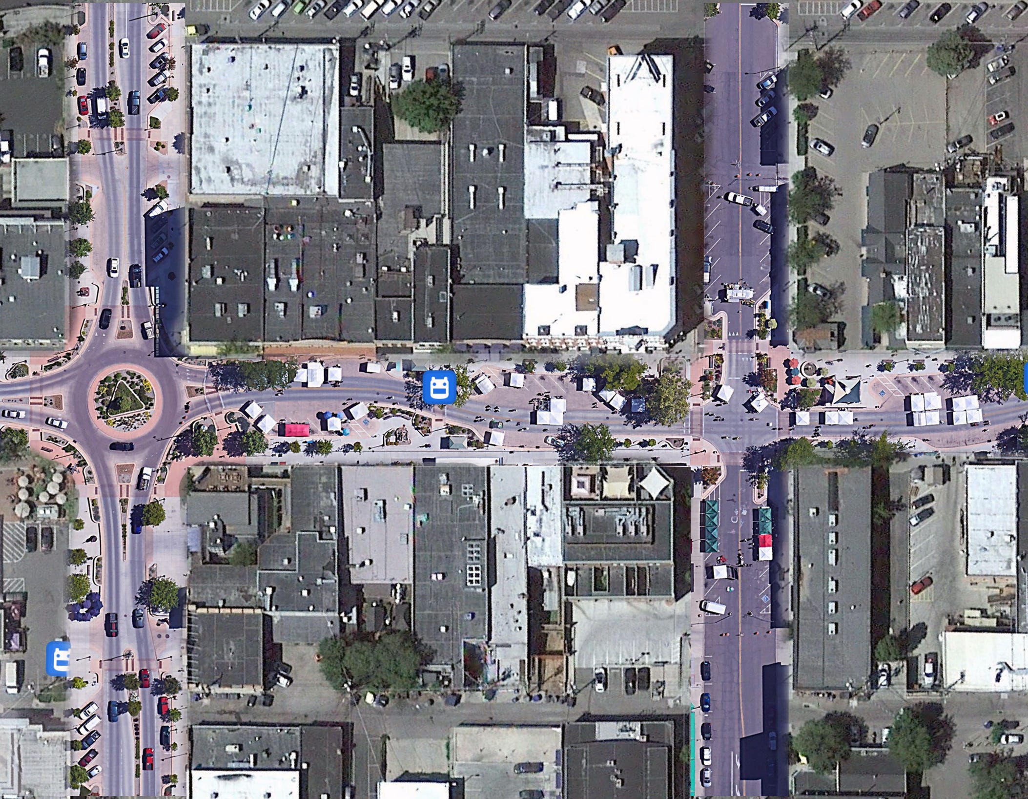
Let’s do Main Ave first, then extend the concept to Second Ave., College Drive, and beyond.
Integrate Animas River Trail (ART) into the rest of the town: If the ART is Durango’s main-stem of human-centered mobility, then it is in dire need of tributaries that extend its awesomeness into the rest of the community. First priority is an overpass or underpass for crossing Camino del Rio at 12th St; and another underpass/overpass at S. Camino del Rio and CR 210. Equally critical is extending it to Three Springs (and, eventually, to Hermosa, Bayfield, Ignacio, Aztec, and Farmington, and how about that branch that goes all the way up Junction Creek to the Colorado Trailhead?)
Revamp the Animas View Drive/CR 203/Hwy 550 intersection (i.e. the Iron Horse Intersection): This is an accident waiting to happen and effectively cuts off non-car-driving residents on CR 203 from getting to the Iron Horse to catch the bus or from joining up with the north end of the Animas River Trail. At the very least put in a traffic light, but a car+pedestrian overpass would be even better for safety and to preserve traffic flow.
Overhaul CR 250/E. 32nd Street from Holly to Florida Road: Or at least put in some stinking bike lanes and sidewalks. Please? This is major linkage between north Durango and the growing Florida Road/East Animas zone is perilous for walkers and bikers.
Public Transit, damnit! Don’t get me wrong: I’m grateful for the Main Ave. trolley line and for the existing bus system. But it’s just not enough. The local transit system must be more robust, cover more area, and run more often. And then it needs to be expanded into a regional system, extending to Purgatory and Farmington, Cortez, Bayfield, Ignacio, and Silverton. It’s wonderful that you can now take a bus from Durango to Grand Junction, but it’s utter insanity that there is no similar bus to Albuquerque. And once that’s all in place, how about working with Farmington, Cortez, and Pagosa Springs to create a truly regional airport?
Thoughts? Rebuttals? Naysaying? Suggestions? Let’s hear it in the comment section below!
PART IV
When I first perused the 1971 planning document this series is based on, “DURANGO! Shaping An Urban Area,” I was surprised at how prescient so much of it was. The planning commission knew the town would grow substantially over the coming decades and if they didn’t do something to manage the growth it would destroy the community they called home. Many of their initiatives—a push to designate greenbelts and open space, for example—eventually came to fruition and now are core elements of the town. Those planners of a half century ago did, indeed, help shape the urban area we know today.
But their foresight did come up short in one realm, namely housing. They simply didn’t, and probably couldn’t, imagine that we would reach a point at which the average home costs well over a half-million dollars; virtually no one from the working class can afford to buy a home without outside help or cashing out of an even more inflated market; and a major concern for local leaders is finding a spot for a permanent camp for the growing number of unhoused residents.
Indeed, the biggest housing-related concern for the 1971 planners was blight. They determined that 22% of the town’s housing was either “deteriorating” or “dilapidated,” with the substandard units concentrated in South Durango, the old Animas City area, and along Florida Road northeast of town. “Unless corrective measures are taken,” the planners wrote, “the deterioration will grow like a cancer.” Little did they know that a reverse sort of phenomenon would occur: gentrification would spread to the “substandard” areas, and the dilapidated homes would become high-demand, high-priced rentals.
While the planners did note that “housing for the low income families should be provided,” they didn’t elaborate much, except to suggest officials “make provisions” to “permit housing for low, medium, and high income groups.” In other words, they would zone some areas for multi-family housing, maybe ease up land-use regulations to make it easier to build more housing, and call it good.
Thing is, while the situation has changed radically since then, the strategy for dealing with the housing crisis has stayed more or less the same. It’s based on the theory that the housing problem is solely one of a supply-demand imbalance: There simply aren’t enough homes (lack of supply) for all of the people moving into a particular area (rising demand), which causes prices to climb. In other words, housing units are just another commodity, like oil or wheat. And what do you do when oil prices shoot sky high? You produce more oil (or, in the case of oil corporations circa 2022, you buy back stocks and reap massive profits) and prices go down. Crisis solved.
Sometimes the housing market does operate under these rules. Take Williston, North Dakota, in the early 2010s. A sudden oil drilling boom caused a massive, rapid influx of population. The small town didn’t have enough housing units to accommodate the boom. Prices shot up to San Francisco- or Manhattan-esque levels. A bunch more housing was constructed. The boom ended. People moved away. Prices dropped. Now you can pick up a house for less than $200,000.
But this dynamic isn’t driving the current housing crisis. While some unaffordable areas do have bona fide housing shortages, it is not the shortages that are driving up prices. (I’m using “shortage” to be: # of households > # of housing units). Let’s look at a really big example, Los Angeles. As is the case in most places in the West, housing prices are going bananas in the City of Angels:
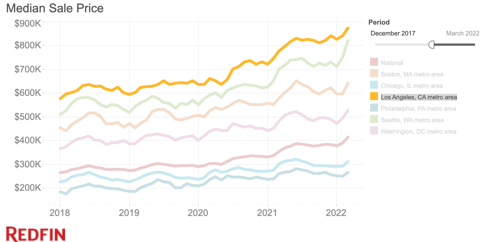
If housing followed simple laws of supply and demand, you might infer from the graph above that the population of Los Angeles has increased faster than the number of housing units over the past two years. But let’s look at another graph, one showing population growth … er … shrinkage in L.A.:
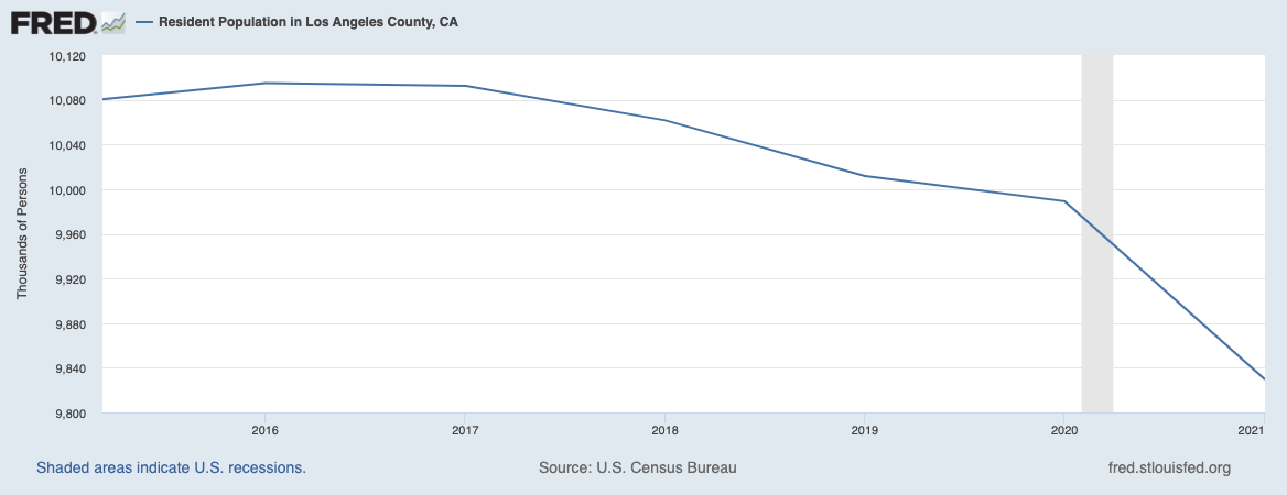
Yes, you read that right: Los Angeles’ population shrunk, with the biggest decline starting right when housing prices started their steepest climb. That’s what you call a negative correlation, folks. And it’s not like the housing stock was shrinking or getting wiped out en masse by earthquakes or forest fires (though there was some of this). In fact, it appears that construction has speeded up over the last couple of years, even though people are leaving.
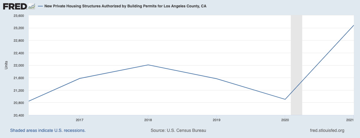
Durango’s not Los Angeles, nor is it shrinking, but a similar dynamic is afoot. Between July 2020 and July 2021 the population of the entire county (La Plata) increased by just 660 people. Yet property values shot up by more than 20% during the same time. Meanwhile, building continued. The City of Durango issued permits for 140 units in 2019, 96 in 2020, and 130 in 2021. La Plata County issued more than 400 permits in 2021.
Students of the supply-demand school will tell you that if La Plata County and Durango merely loosened land-use regulations and made it easier for developers to build even more housing, then they’d increase the housing stock, alleviate the scarcity, and prices would go back down. While that is the intuitive solution, a simple thought experiment shows it wouldn’t work that way.
Because it’s more contained, and smaller, let’s take this experiment to Telluride, home of multi-million dollar shotgun shacks. Imagine for a moment that the Town of Telluride, wanting to find a solution to the housing crisis, sold 20 acres of land on the Valley Floor at market rate to a developer and eased building regulations on the condition that the developer build at least 150 housing units (but adding no other restrictions). Because that would be a dramatic increase in the town’s housing stock, it should cause housing prices to decrease substantially—if, indeed, this were a simple matter of supply and demand.
Would that happen? No. Why? Because investors, second-home owners, and others with cash would come in and snatch up every one of those units, almost regardless of the asking price.
Another example can be found back in Durango. The Three Springs development outside of town didn’t even exist a couple of decades ago. Now it is home to hundreds of housing units and continues to expand. Yet prices are also going up there, regardless.
That’s because the problem here is not that there is a lack of housing, but that there is a lack of affordable housing. And there is a lack of affordable housing because there’s too damned much money out there and the handful of people who have accumulated all of that wealth are happy to spend it on overpriced housing, locking everyone else out of the market. If you build more houses, those same people will just come in and buy them as investments, or to turn into short-term rentals, or to spend a few weeks each year in them, leaving them empty the rest of the time, simply because they can.
So the solution is to build more affordable housing, not just more housing. Nonprofits can do some of this, but mostly it will be up to governments, from the federal on down to the local level. And it has to be a massive effort. It’s great when a town buys a house and converts it into a dorm for a half-dozen workers and all, but it’s not going to cut it. These communities need hundreds of affordable, livable units.
How do you pay for it? Simple: Taxes. Progressive taxes. On a federal level, reinstate the marginal tax rates of the postwar era, when annual incomes above a certain amount were taxed at a rate of 90% or more. And on a local level implement a progressive real estate transfer tax. By progressive I mean ratchet it up according to the dollar amount of the sale. Sales under $300,000 would have no tax; $300,000 to $500,000 would have a 1% tax, $500,000 to $1 million a 3% tax; and above $1 million would be 5%. Put all of the revenue into an affordable housing fund.
Unfortunately, Colorado blocked communities from implementing new real estate transfer taxes (some towns, like Telluride, are grandfathered in; its 3 % tax has generated at least $4 million per year since 2004 and in 2020 brought in more than $14 million). Still, that’s reversible. State lawmakers simply need to get off their duffs and nix that one from the books. Then towns and counties need to stand up to the real estate industry and implement it.
As for states don’t have the same hurdles to overcome, what are they waiting for?
EPILOGUE: THE USED-TO-BE GAME
I’m going to digress a bit here by playing the “used-to-be” game to help readers who may not remember or may not be old enough what Durango was like in the early 1970s. I don’t remember anything from 1971—I was less than a year old. My first memories with a time stamp kick in during 1974, when nearly a block of buildings on Main Avenue burned and we drove up onto Cemetery Hill to watch the drama unfold.
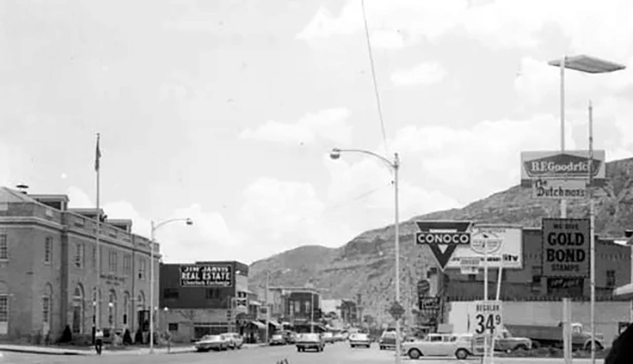
I’ll start from the north side of town, leaving some answers blank to give y’all a chance to play the used-to-be game! If you can fill in the blanks, do so in the comment section (accompanied by the number next to it):
Animas View Drive and County Road 203 (West Animas) used to be the main highway out of town (the “new highway” was, indeed, new in 1971);
There used to be a nightclub where the Hampton Inn is now called (1a)_______. I always found it a little titillating, though I never went inside. Maybe it was the pink neon sign?
The place that is now Griego’s restaurant (green chile Frito pie!) used to be one of two (1b)_______ in town (and Griego’s Taco House—29 cent sno-cones!—was where (2)_______ is now).
The current recreation center used to be the county fairground with a stone/wood grandstand that was hell to run up and down (for xc ski training) and splintery as all heck. They held circuses, rodeos, and Durango high school football games here.
(3)________ was located where the public library now sits.
Camino del Rio, known at the time as the Truck Bypass, was brand new in 1971. Prior to that, Main Avenue had been the primary highway through town; travelers turned left on 6th Street (College Drive), then right on 8th Ave to get to the main highway out of town, Highway 3, on the east side of the river, past a huge sawmill. In 1971 Highway 3 remained the primary southern artery (the “High Bridge” near Walmart wasn’t constructed until the early 1980s).
Second Ave., meanwhile, was home to car dealerships, including Morehart Chevrolet and Murphy Motors.
In 1971 massive uranium tailings piles loomed over the south side of town, at the current location of the dog park.
(4)_________ Road, now a popular mountain biking area, was open to motorized vehicles (and served as a de facto town dump, off-roading area, and high schooler party zone).
The (5)_______ used to be the Thompson Saddle Shop (and other businesses—bonus points for whoever can name them in the comment section). To its south was the (6)_________ movie theatre. and downtown Durango also sported (7)_______ (where you’d go for a tie or suit) and (8)_________ (you got your Levis or Wranglers here). You could get a steak and cocktail at The Lost (9)______, and pizza and a beer at (10)_________ (Ralph Dinosaur’s home bar). The back of (11)________ pharmacy was a soda fountain, where one could get a phosphate and a burger and where, purportedly, town powerbrokers met. The 11th Street Station really was a service station named (12)__________. And there was a lunch counter in (13)______________, which is now an upscale restaurant on the 900 block of Main Ave.
Oh my! Count that manila envelop and the "use-to-be" game it inspired are definitely some of the richest gems pulled from that valley in a long time! However, I am mad at you for including Griego's in your game because my pavlovian response has me drooling like a Labradork thinking about their green chili. And it's 11:15 at night! Tonight is ruined...
What a wild side-by-side photo. It's astonishing how stark Tupperware Heights appeared when it was first built. I can only imagine how folks felt about it at the time. Crestview has, for the most part, really aged into a nice neighborhood.
Too bad they were never able to implement a public greenbelt along Junction Creek. That would've been pretty amazing.