

The tropical moisture keeps moving into the Southwest, triggering flash flood warnings from southern Colorado to the U.S.-Mexico line. This round of rain has and will continue to pound southern, central, and northeastern New Mexico the hardest. Mora County, on the east side of the Sangre de Cristo Mountains, was pummeled by precipitation and flash flooding. Some parts of New Mexico could receive several inches of rain during the next round of storms today (Wednesday) and tomorrow.
Given that, it seemed appropriate to pull this piece on historic flooding in the region out of the Land Desk paywalled archives, dust it off a bit, add a few updates, and run it again for all readers — paid and freeloaders — to get a gander.

“A fellow who thinks the ‘river of lost souls’ won’t do to watch, has all the feathers out of his willow plume. She may look meek and sleepy-eyed but don’t tickle her heels.”
—Durango Wage Earner, October 12, 1911
At around four a.m. on October 6, 1911, Navajo Methodist Mission Superintendent J.N. Simmons woke up to find himself and the mission near Farmington, New Mexico, surrounded by water. It wasn’t a total surprise. He and two other staffers—Frank B. Tice and Walter Weston—had received the flood alarm the previous day, but had chosen to stay, certain that the San Juan River’s waters would never reach them, and if they did, the brand new, three-story cement-block mission building, watched over by God, would provide an unsinkable refuge. They were wrong.
The rain began in the San Juan Mountains late on the morning of October 4, 1911. It came down gently at first, slowly gaining intensity over the course of the day. By evening the tropical storm was a torrent, dropping two inches of precipitation on Durango in just 12 hours, nearly twice what the town normally gets during all of October. Weather watchers in Gladstone, above Silverton, recorded eight inches of rain on October 5—a virtual high country hurricane1.
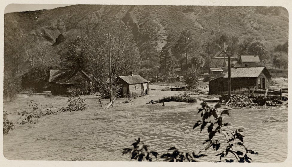
Once-gurgling streams jumped from their banks and twisted steel railroad tracks into contorted sculpture, decimated roads and bridges, and demolished barns. Junction Creek tore out the Main Avenue and railroad bridges before adding its load to the Animas, which carried an estimated 25,000 cubic feet per second of water as it ran through town. It’s an almost incomprehensible volume. A good spring runoff these days might lift the waters to 6,000 cfs, high enough for the river to leave its banks and spread across the floor of the Animas Valley, and to turn Smelter Rapid into a churning hellhole for rafters.
The water unmoored the railroad bridge near Durango’s fish hatchery and carried it downstream, despite the fact that two full coal cars had been parked on the bridge to provide ballast. The river jumped its channel and headed onto 15th street, creating a five-foot-deep river that today would go right through a Burger King. further downriver the waters washed away 100 tons of toxic slag from the Durango smelter, and carried away several homes from Santa Rita, on the opposite shore.
Sixty miles east of Durango, in Pagosa Springs, the upper San Juan River swept away more than 20 structures and destroyed the town water plant, hospital, and jail. Its power plant “was wiped out of existence, nothing left but the water wheel.” The Bayfield Blade called Arboles, a village near the junction of the San Juan and Piedra Rivers, “a thing of the past.” That was a bit of hyperbole, but maybe also prophetic: the community survived that flood, but was later buried under the waters of Navajo Reservoir. Further east the Rio Grande grew even grander and threatened to carry parts of Española, Bernalillo, and Albuquerque down to the Gulf of Mexico.
Over in Dolores, Colorado, the river peaked out at 10,000 cfs, more than 20% greater than the second highest peak hit in 1949. The raging river of sorrow ripped out railroad tracks, washed out roads, and inundated the town under four feet of water and four inches of mud, carrying away houses and the boardwalk. My great grandfather, John Malcolm Nelson, had come down from Ouray in early October to look at buying land in the Ute Strip — and he did, down at Sunnyside Mesa. But his trip back north was delayed by the fact that every bridge and road in the region was washed out.
In Farmington the seething monsters of the upper San Juan and the Animas joined forces, spilling over the banks and onto the flats on either side of the river, where the Navajo mission sat. Simmons and his fellow staffers sent the children to higher ground at about midnight as a precaution, equipping each with a blanket and loaf of bread. Then they went to bed, not realizing their own mistake until they awoke four hours later.
Somehow, Weston was able to quickly escape on horseback (he may have snuck out earlier). Tice chose to stick around, heading for the top floor of the structure. Simmons ran out and climbed atop an outhouse, apparently in order to launch himself onto a horse. Simmons missed the horse and ended up in the water, instead, carried rapidly downstream alongside dead animals, haystacks, and pieces of people’s homes.
Tice, it seemed, was the only survivor, and as the sun came up, onlookers gathered on the opposite shore. They watched Tice climb from the second story to the third, finally climbing onto the roof with his dog. It seemed safe enough; the water stopped rising after it inundated the third story. Little did he know, the waters were slowly dissolving the building underneath him, and it, the roof, the dog, and finally Tice were all swallowed up by the current.
Downstream, the Shiprock Indian School campus was covered with water five feet deep, washing away several adobe buildings. The fairgrounds, prettied up for the annual fair, were covered with a torrent of muddy water. Every bridge in San Juan County, Utah, where a miniature oil boom was on, was torn loose and carried away by the angry torrent; 150,000 cubic feet of water shot past the little town of Mexican Hat every second, according to a 2001 USGS paleo-flood hydrology investigation. That’s about 100 times the volume of water in the river during a typical March or April, a popular time to raft that section. It took out the then-new Goodridge bridge — some 39 feet above the river’s normal surface — tore through the Goosenecks, backed up in Grand Gulch, deposited trees on sandstone benches high above where the river normally flows, and finally combined with the raging Colorado River to create a liquid leviathan of unknown volume that wreaked more havoc through the Grand Canyon and beyond.
***
The 1911 event is typically considered to be the Four Corners Country’s biggest flood, based on streamflow estimates, anecdotal accounts, and the damage wrought. Since then it has been rivaled only by the June 1927 flood, when the Animas River in Durango reached 20,000 cubic feet per second; and in 1949 and 1970 when the high-water mark was about 12,000 cfs and 11,600 cfs, respectively. That might make 1911 seem like a freak event — a once-in-a-millennium confluence of factors. Combine that with the fact that the river’s annual peak streamflows have trended downward over the last century or so, and a 1911 repeat seems less and less likely.
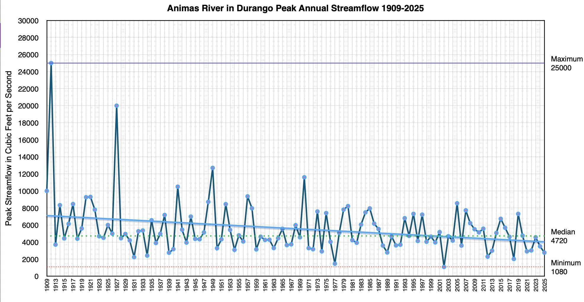
But these waters are muddied, so to speak, by the relatively short timeline and limited geographical scope we’re working with. Many streams didn’t have gages on them at the time, and even those that were present weren’t always accurate (most of the 1911 figures are estimates, not actual measurements). Even though most of the “old-timers” said it was the biggest flood they’d ever seen or heard of in these parts, we have to remember that they tended to be white guys, and white settler-colonists had only been in the area for four decades or so. Not that memories of weather events are ever all that reliable.
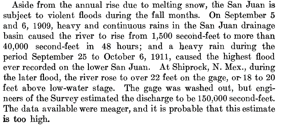
The San Juan River is especially prone to extreme fluctuations in flow. It is a shapeshifter, shallow and languid and warm at one moment, raging and violent the next. Mormon settler and chronicler of San Juan County, Utah, Albert R. Lyman, wrote that during an especially severe 1890s drought, the San Juan through Bluff nearly dried up, and “small pools were writhing with dying fish, and hunting them out of the larger ponds became a winning sport. Navajos offered them for sale by the sackful. In fact they learned, contrary to their old traditions, that fish are good to eat.” Yet so many San Juan floods ripped through — including in 1884 and 1911 — that Lyman also wrote, “the old river seemed bent on retaking every acre of its ancient dominion.”
In fact, the river literally reconquered its old territory and scuttled the newcomers, completely destroying the settlers’ irrigation works and washing away parts of Bluff City. The Hole-in-the-Rock settlers that founded Bluff on the banks of the San Juan would eventually virtually abandon the settlement and head to higher ground, where they founded Blanding née Grayson. They wouldn’t have that moody river to deal with anymore, and were still able to get water by diverting Indian Creek through the Abajo Mountains via a hand-dug tunnel.
While the 1884 flood was more destructive to Bluff than the one in 1911, it may not have been bigger. There were virtually no stream gages in 1884, so the magnitude of that earlier event is hard to quantify and, besides, maybe the later flood was less destructive because there were fewer homes and infrastructure in the flood’s path by then.
Also, when one looks beyond the San Juan Basin watershed, one finds streamflows that far exceed those of October 1911. On the USGS stream gage on the Green River in Green River, Utah, the 1911 flood (which was at the beginning of the 1912 water year, by the way) ranks as just the 5th largest flow since 1895. And 1911 places fourth overall on the Rio Grande at Otowi Bridge, outdone by 1920, 1941, and 1904.
We can extend the timeline dramatically by turning to paleoflood hydrology, which is sort of like dendrochronology, except instead of looking at tree rings to understand past climate, it uses geological evidence — slackwater lines, debris — to reconstruct the magnitude and frequency of past floods. I skimmed the available literature, including this Bureau of Reclamation survey of studies, and here’s what stood out:
The 1911 flood was likely the largest on the Animas River over the last several hundred years or more. On the San Juan River near Bluff, researchers found no evidence of floods higher than the 1911 debris, indicating it “may represent the largest flood on the San Juan River for a much longer time period than 1880-2001.” In any event, 1911 was larger than the 1884 flood, even in Bluff.
On the Colorado River at Lees Ferry the 1884 flood was most likely the largest during white settler-colonial times, with an estimated flow of about 300,000 cubic feet per second (there were no gages there, yet), which would have provided quite the ride through the Grand Canyon. This would have been about three times the maximum flows during the 1983 floods, when Glen Canyon Dam operators were forced to release vast amounts of water from Lake Powell to protect the dam. Some researchers believe an 1862 flood had a flow of about 400,000 cfs. Holy big water, Batman!
Extend the timeline further and the ride gets even wilder: A 1994 USGS paleoflood study found evidence of a 500,000 cfs flood at Lees Ferry between 350 and 750 A.D.; and a 2018 reconnaissance found slackwater deposits indicating a flow of 700,000 cfs. I’m sure it provided quite the scene for Puebloan observers looking down from the canyon rim. If you happened to be in the canyon at that time? Yikes.
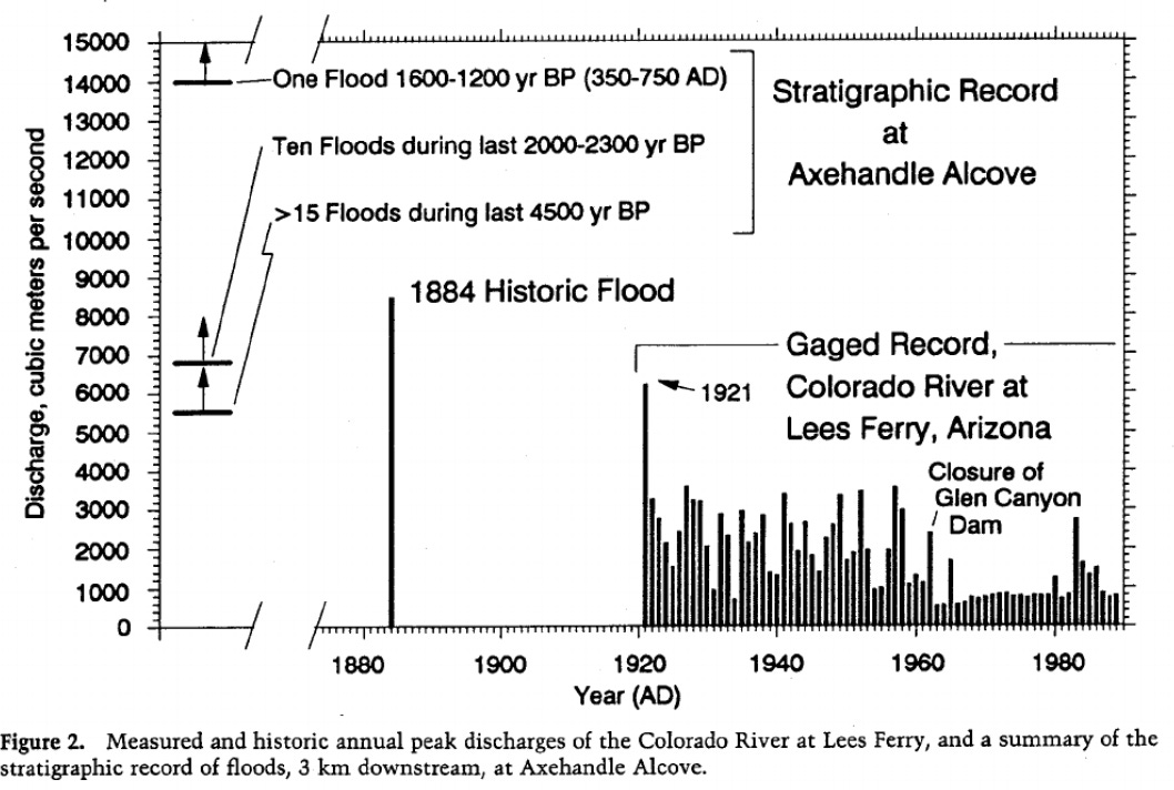
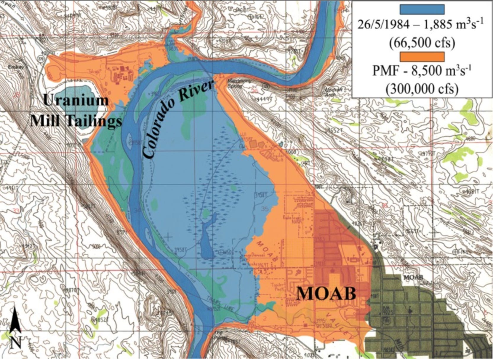
A study of floods on the Colorado near Moab found that, as is the case on the Animas River, there were a lot of large floods between the 1880s and 1930s, but peak streamflows have followed a decreasing trend ever since. One study suggested this resulted from: land-use changes, particularly a severe reduction in grazing after 1932; greater regulation of the river by upstream dams and so forth; greater upstream water consumption; and a decrease in intense, large flood-producing storms.
The Colorado River near Moab has experienced 44 floods during the last two millennia with flows ranging from 63,500 cfs to 325,000 cfs. (For context, the 1983 runoff, which threatened Glen Canyon Dam, reached 62,000 cfs on this stretch of river and in 1984 it hit 70,300 cfs). Most of those floods occurred during the last 500 years.
If you go way, way back to the Pleistocene, things got really crazy when glacial moraine dams burst, leading to catastrophic glacial outburst floods. This happened on four occasions on the Animas River when the contents of proglacial Lake Durango blasted downstream, making modern floods look like puny, according to this Colorado Geological Survey paper.
Warming temperatures, like those resulting from human-wreaked, fossil fuel burning-exacerbated climate change, can increase the amount of moisture in storms, and therefore supercharge the intensity of storms and the amount of precipitation they produce. That could, potentially, lead to bigger floods. So even though climate change has mostly manifested as drought in the Four Corners Country, it could also have the effect of putting a 1911-like storm on steroids. And with El Niño brewing in the Pacific (9/2026 update: Make that a Super El Niño), we might see some whopper storms sooner rather than later. Or not. Either way, though, it seems silly to assume the 1911 flood won’t repeat someday. Maybe next time it will be even worse.
That 1911 storm dissipated over the next couple of days, leaving a bright sun to illuminate the river valleys, newly scoured of the roads, houses, bridges, railroad tracks, and other detritus that humans had littered the valleys with over the previous decades. But the folks of the San Juan Basin soon went to work rebuilding — quite often in exactly the same spots that had flooded so catastrophically.
I used to see that as a combination of foolishness, hubris, obliviousness, and stubbornness all woven into a tapestry of denial. Surely they couldn’t have believed a flood of that magnitude would never occur again.
And yet, now that I’ve fallen victim to a flood, or at least my home has, I finally get it. What do I know about their circumstances? Maybe they had invested everything they owned into this little plot of land and a home, and they have nowhere else to go. Maybe they are just so wedded to this particular place that they figure it’s worth the risk to build in a 100-year flood plain. Maybe they were just tenacious bastards shaking their fist at the sky in defiance.
What I do know is that if and when there is a repeat of the 1911 flood, or that whopper that sent 700,000 cfs into the Grand Canyon, it will leave some serious destruction in its wake.
The 1911 flood wrecked a lot of infrastructure, but the human death toll was much smaller than one might have expected. Among the handful of fatalities was Frank B. Tice, of the Navajo Methodist Mission, whose body was found 20 miles downstream from where he was swept away.
But there was something else, too. On an island in the San Juan River, somewhere between Farmington and Shiprock, a man huddled next to a small fire, cooking apples that he had snagged as they bobbed past. After falling in the water he had grabbed ahold of some debris, and it had carried him for miles until he finally reached the island, cold, wet and hungry but, maybe miraculously, alive. It was J.N. Simmons, of the Navajo mission.
A 1998 paleo-flood investigation determined the measurement was in error and it was more likely that about four inches fell across a wider area. In any event, the author of the report does not dispute the magnitude of the flood that resulted.
“we have to remember that they tended to be white guys”
You’re funny. And I cannot wrap my head around how much research you do. Well, you probably just don’t have a life.
My house was flooded in the Northern Front Range floods of 2013, so I do get a kick out of flood stories. There, lots of moisture kept coming in normally dry Sept and early Oct and the evening before the final deluge I told my wife, "Don't worry, it does this all the time in Vermont." Since then she uses this against me whenever I'm claiming "It will all be fine..."
Recent measurements show that our warmer atmosphere holds almost 10% more water than just 1980, let alone "pre-industrial" era of 250 ppm CO2 and lower CH4, etc. https://skepticalscience.com/atmosphere-set-water-vapor-record.html
That has a nice discussion/definition of precipitable water "PWAT" which is often referred to in the great "Area Forecast Discussion" on our GJ NWS site. It's great because the meteorologists always highlight their uncertainties with their own regional and local predictions.
And, from the American Geophysical Union August 2026 "Earth's Future" journal:
"Hot Droughts Increase the Likelihood and Impacts of Abrupt Drought-to-Pluvial Transitions Worldwide" Open access at https://agupubs.onlinelibrary.wiley.com/doi/10.1029/2026EF008638
"Pluvial" being a fancy word for "abundant rain" or "wet!"
In the "Plain Language Summary:"
"Here, we show that droughts accompanied by extreme heat are much more likely to transition into intense rainfall events than droughts without heat. These heat-related transitions occur more frequently, develop faster, and produce stronger and longer-lasting rainfall. This happens because heat alters the atmosphere in ways that make it easier for rainfall to be triggered once moisture becomes available." Seems relatable here now.
I can't find the link, but I recall some hyper local simulations of near future climate in the Western US that showed slightly more annual precip in the SW up to about the Elks and W. Elks, but with more falling during monsoons instead of winter.
So, there's some nerdy stuff to baffle anyone who says record floods and aridification are a contradiction and "the climate is always changing." Not like this it ain't. Or, as my science teacher buddy simply says, "The atmosphere has more energy," which can manifest as "heat domes" or deluges, even back to back. I seem to be more long-winded.