Lake Powell's bad math persists; USFS greenlights AZ mine; AZ river runs dry
Plus: Faraday's Copper Creek project has deep-pocketed backers
🐟 Colorado River Chronicles 💧
The Colorado River watershed’s spring runoff — if you can call the measly increase in streamflows “runoff” — peaked in mid-May and was pretty much over by mid-June.
The variations in streamflow showed up as a little bump in Lake Powell’s total inflows, which were augmented by extra releases from Flaming Gorge reservoir on the Wyoming-Utah border, many miles upstream. That buoyed Lake Powell’s surface level to a high point of 3,528 feet in early June, before it began its long decline that’s likely to continue until next year’s runoff.
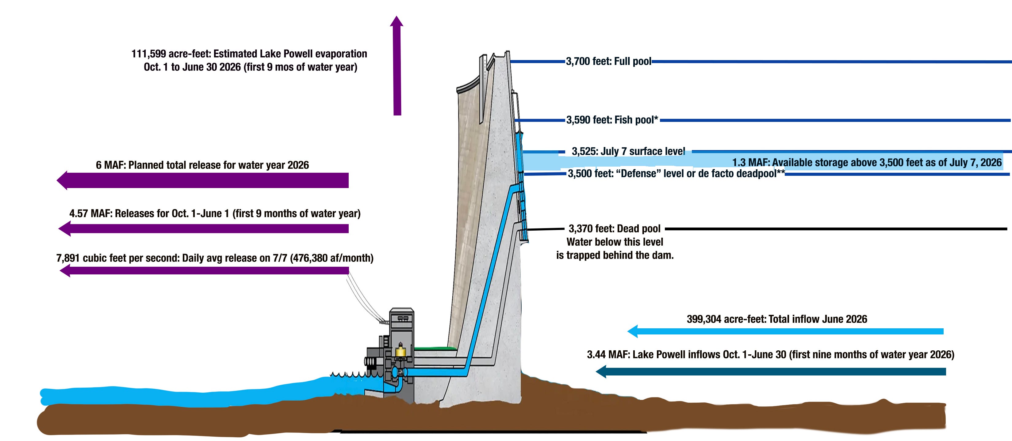
The reservoir’s surface level is currently at about 3,525 feet, the lowest it has been since 2023 and the lowest it has been on this date since it was filled. It’s also the level that would trigger a reduction in releases from Glen Canyon Dam to 7.48 million acre-feet per year. This year that’s not going to happen, because releases are already on track to be closer to 6 MAF.
The data show why, even with reduced releases, the surface level is falling at about two inches per day as of the beginning of July.
3,527.97; 3,524.99 feet above sea level: Surface elevation of Lake Powell on June 1 and July 6, respectively.
2.1 million acre-feet: Median total inflows into Lake Powell (1991-2020).
399,304 acre-feet: Total inflows into Lake Powell during the month of June 2026, or about 19% of “normal.” The “unregulated inflow,” which is what the inflow would be without augmentation from upstream reservoirs, was just 305,000 af.
507,747 acre-feet: Total releases from Glen Canyon Dam in June 2026. At this level, all releases go through the hydroelectric turbines and generate power.
20,475 acre-feet: Estimated amount of water lost to evaporation from Lake Powell in June 2026.
8,951 acre-feet: Inflow into Lake Powell on July 7, 2026.
15,546 acre-feet: Release from Glen Canyon Dam on July 7, 2026.
788 acre-feet: Estimated evaporation from Lake Powell on July 7, 2026.
(7,383 acre-feet): Lake Powell’s daily water deficit on July 7, 2026.
In other words, as of early July the reservoir was losing nearly 7,400 acre-feet of water each day, or about 220,000 acre-feet per month. If this rate of decline continues or speeds up, then we can expect the reservoir to reach de facto deadpool — or 3,500 feet — before the end of the year.
If the level drops below 3,500 feet, dam operators will no longer be able to release water through the penstocks and hydroelectric turbines, meaning they must rely entirely on the river outlets lower on the dam for all releases. This would not only zero out the dam’s hydropower output, but could also damage the outlet tubes, since they aren’t engineered for long-term, sustained use.
One possible scenario: Dam operators switch to the river outlets for releases, the reservoir’s surface level is drawn down to, say, 3,475 feet, then the river outlet tubes begin deteriorating due to cavitation, forcing them to be shut down. This would then make it impossible to release any water from the dam until the outlets were repaired or the lake level rose back up to 3,500 feet, meaning the Colorado River in the Grand Canyon would effectively dry up completely.
That’s why the Bureau of Rec is so intent on “defending” that 3,500-foot level, presumably even if it means going to a run-of-the-river operation, in which water is released from the dam at the approximate rate that it is flowing into the reservoir, minus evaporation. On July 7, this would have amounted to about 2,800 cubic feet per second, or about one-third of current releases, diminishing hydropower output, and affecting downstream recreation and aquatic life.
If — or more likely, when — this occurs, it will render Lake Powell useless as a water savings account, and reduce it to a marginal power generator, silt collector, and evaporation pool. Boating will still be possible, but most existing boat ramps will no longer be usable. This will lend strength to calls to drain the reservoir, either by decommissioning the dam altogether, or by building bypass tunnels that can be shut down if climatic conditions change and aridification is reversed.
⛏️ Mining Monitor ⛏️
The U.S. Forest Service granted final approval to South32’s proposal to re-open and expand the Hermosa Mine in southern Arizona to extract battery materials such as manganese and zinc, along with silver and lead.
The mine is on patented claims (private land), but would be expanded onto unpatented claims in the Coronado National Forest in southern Arizona’s Patagonia Mountains, an area long inhabited by the Sobaipuri O’odham and Hohokam people. The mountains occupy the nexus of several different biological provinces and are home to hundreds of species of birds, bees, bats, and butterflies, as well as the unique Madrean Pine-Oak Woodlands.
The approved plan of operations includes:
Disturbance of about 400 acres of Forest Service land, including 225 acres for tailings and waste storage.
Mining will be done by the long-hole open stope method at a projected rate of about 4.7 million tons of ore per year.
The Australian company has approval to discharge up to 4,500 gallons per minute of treated water into Harshaw Creek, Mowry Wash South, and Goldbaum Canyon.
During operations the plan anticipates 169 heavy truck round trips per day and 76 light vehicle or bus round trips per day on the main access road, which will be constructed for the project.
The Biden administration expedited the environmental review for the proposed plan back in 2023 because the materials extracted are considered “critical.” Manganese is used in large capacity batteries; zinc is used to galvanize steel.
Area residents and advocates worry this sort of industrialization will harm the delicate and unique ecosystem and the diverse array of wildlife that depends on it. As is often the case with underground hardrock mining, a primary concern is for its effects on water quality and quantity. Groundwater pumping is expected to deplete area aquifers, which could affect springs and wells. Acid mine drainage is expected to occur in the sulfide ore body, which, if not treated properly, could contaminate groundwater or streams in the arid region.
The West these days is teeming with so many fly-by-night mining companies and speculators staking claims on public lands and launching exploratory drilling projects that it’s hard to tell which ones to take seriously. Most of these bids will likely fizzle out as soon as commodity prices fall.
Faraday Copper’s Copper Creek Project, however, seems to be worth paying attention to, if only because they have some serious financial backing.
The Canada company just finalized its agreement to acquire the shuttered San Manuel copper mine in southern Arizona from BHP Group Limited. BHP, a global corporation and a co-proponent of the proposed Resolute copper mine at Oak Flat, will take a 30% equity interest in Faraday when the deal is completed later this year.
The San Manuel mine, just outside Mammoth, Arizona, was once the nation’s largest underground copper mine and a significant producer up to its closure in 1999. “The definitive agreement provides a pathway for the development by Faraday of a new copper hub in Arizona,” said a BHP press release, “combining existing infrastructure and mineral inventory at San Manuel with Faraday’s adjacent Copper Creek project.”
The proposed Copper Creek mine covers about 78 square kilometers in the Galiuro Mountains about nine miles east of Mammoth. Its open pit would likely be in the middle of Copper Creek, a tributary to the Lower San Pedro River. Last June, the Bureau of Land Management approved Faraday’s plan to construct 67 drill pads, along with associated roads and infrastructure, and the company recently completed the first round of water-intensive drilling. The firm reports that the drilling identified oxide mineralization that “supports potential open-pit resource expansion.”
For now, at least, Faraday is not really a mining company. It holds mining claims at the Copper Creek project in Arizona and another “pre-feasibility” project in Nevada, but it has yet to do any actual mining. It’s an exploratory company that last year posted a net loss of nearly $28 million.
Still, it’s getting some help from some very deep-pocketed interests. First off there’s BHP, assuming the San Manuel deal goes through. And then there’s the backing of the Lundin Group, which owns metal and diamond mining, petroleum, and renewable energy companies around the world. Lundin, which was founded in Sweden, is also known for human rights violations. Two executives of Lundin Oil (now Orrön Energy and owned by another company) allegedly aided and abetted war crimes in what is now South Sudan in the late 1990s and early 2000s. Their trial in Stockholm ended in late May and a verdict is expected later this year.
The development has sparked pushback from residents, advocates, and tribal nations, who worry about the drilling’s potential impacts to water quantity and quality in the Lower San Pedro River, which flows nearby, not to mention the prospect of a giant open pit mine in the biodiverse mountain range. The proposed mine site is also near the Aravaipa Wilderness Area, a stunning canyon and desert riparian zone.
There’s also an ironic twist to this situation. In order for Resolution Copper — a BHP/Rio Tinto partnership — to move forward on its Oak Flat mine near Superior, Arizona, about 40 miles northwest of the Copper Creek project, the company had to do a land exchange. It would take ownership of Oak Flat — USFS land that had been withdrawn from mineral entry in 1955 — in exchange for various private parcels in the region with environmental or recreational significance. One of those gained by the federal government is a 3,050-acre parcel along the Lower San Pedro just east of Mammoth; putting it in federal hands should have protected the stretch from development. But it also covers the Copper Creek-Lower San Pedro confluence, and lies between Faraday’s Copper Creek Project and BHP’s San Manuel Mine. In other words, it would potentially be affected, directly or indirectly, by Faraday’s project.
Actual mining isn’t going to happen anytime soon; Faraday has paused its drilling program for the summer and doesn’t plan to resume until the fall. But the deal with BHP and the funding from Lundin are reason enough to keep an eye on this one.
🥵 Aridification Watch 🐫
Speaking of the San Pedro River, one of southern Arizona’s iconic streams and biodiversity zones, it reportedly has gone dry for only the second time in the last century at its Charleston gage. To be clear, the San Pedro is not a huge river, and it has been reduced to a mere trickle at times. But for it to completely vanish at this particular gage — the last time it happened was in 2005 — is a sign that aridification and groundwater overpumping are coming together to destroy one of the last un-dammed desert rivers in the Southwest.

Of course, the San Pedro is not alone. Nearly every stream in the Interior West is running at below normal flows currently. The Dolores River below McPhee Dam is so depleted that a helicopter searching the stream for water to dump on the Ferris Fire came up empty. The San Miguel River at Uravan, Colorado, is flowing at just 6 cubic feet per second, which is about 2% of the median flow for this date. And the Animas River below Aztec, New Mexico, is running at a measly 16 cfs, which is far too low for Farmington’s surf wave.
And of course, we can’t forget about the beleaguered Rio Grande. Laura Paskus reports that 87 miles of the Middle Rio Grande have gone dry. She has a heartbreaking account of walking a stretch of the dry zone near Albuquerque at her Substack newsletter.
Unfortunately, conditions are likely only to get worse this weekend, as a heat wave moves in and scorches the West, especially parts of the central and northern Rocky Mountains. Temperatures are forecasted to reach the triple digits in places like Hotchkiss and Grand Junction, Colorado. And check out this weekend forecast (7/11-7/14) for Thermopolis, Wyoming.

🤯 Oh, the Humans! 😱
The San Miguel County Sheriff’s Office is a bit irritated, if their social media posts are any indication. This week they received a Garmin SOS signal from someone who had apparently fallen 150 to 200 feet in the Columbine Basin above Telluride, broken his leg, and needed search and rescue’s help.
Following an extensive rescue team deployment, which included a CARE Flight helicopter flying into the scene at 13,000 feet in elevation, the SAR team found the victim walking around. He told them he was BASE jumping on his own, his chute didn’t open, and he was injured in the fall. But the broken leg thing? Nope: He not only refused a helicopter flight, but any assistance at all. Adding to the annoyance: The purported victim had previously triggered a massive SAR operation while BASE jumping in the Swiss Alps that included a $175,000 air evacuation.
“Our SAR team consists of skilled professionals who risk their own lives to help others in need,” said Sheriff Dan Covault in a statement. “This individual chose to participate in an extremely dangerous activity alone, and particularly given his prior rescue history, his actions demonstrated a disregard for the risks involved and the resources required to rescue him. His decisions unnecessarily diverted emergency resources, including a Care Flight helicopter, that may have been needed for other emergencies. The fact that he was able to hike back down shows a profound lack of respect for the tremendous effort and resources devoted to this rescue.”
📸 Parting Shot 🎞️
Images from badlands in northwestern New Mexico that Georgia O’Keefe painted and called the “Black Place.”


