Introducing the Mining Monitor Map
Plus: Why do mining companies hide their identities when making claims?
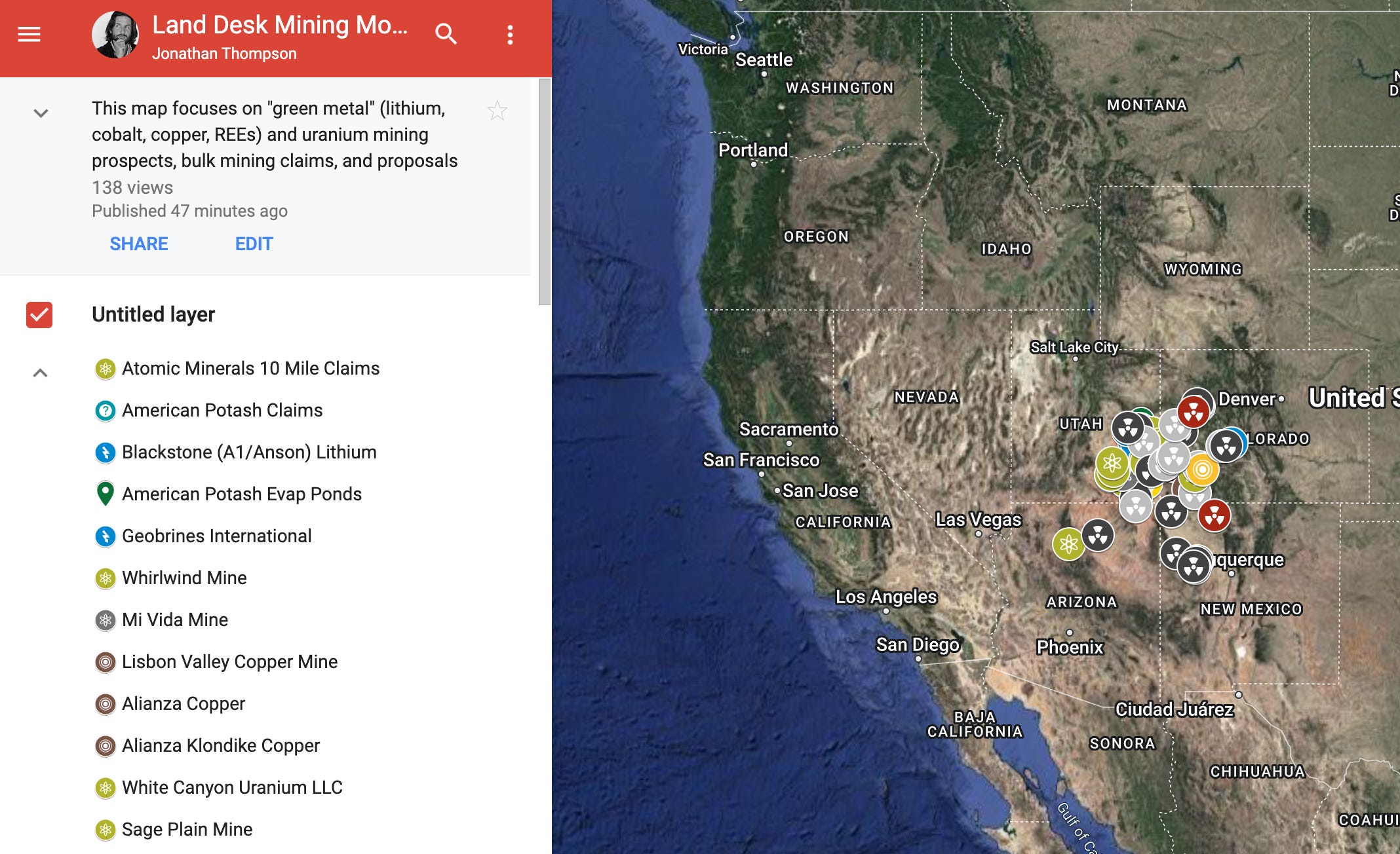
Introducing the Land Desk Mining Monitor Map, on which I track the “green metal” and uranium land rush currently underway in the Four Corners Region — and, eventually, beyond. It’s not quite as spicy as the Land Desk Green Chile Atlas, but it is hot in a much different way.
I started out by compiling notable mining claims filed over the past year or so in southeastern Utah and western Colorado that appear to be for lithium, copper, or uranium mining. Then I scoured the intertubes for mining proposals, expansions, major acquisitions, and exploratory plans. And then I added major Nuclear West legacy sites (mostly mills and tailings disposal sites). I have not yet added many abandoned uranium mine sites, in part because there are thousands of them in the Four Corners area alone. But I will gradually add some of the biggest ones or those with known contamination issues. I’ll also begin expanding the scope outward to cover more ground.
A few things struck me as I put this together. First, the vast amount of land that is being “claimed” by mining companies, prospectors, and speculators is mind-boggling. Second, the number of contaminated uranium-related sites is stunning. And, third, it’s clear that the next mining boom—assuming it comes to fruition—will take place mostly in areas that have already been ravaged by mining, such as the Lisbon Valley and Uravan Mineral Belt. Places that are still being cleaned up (or neglected) from the last time they were mined.
So check it out and let me know what strikes you about it. And please, if you know of any projects or proposals that should be added, let me know!
Now onto the latest edition of the …
… Mining Monitor
One of the tough things about tracking mining claims is that the claimants often try, for reasons unknown to me, to hide their identity. Just check out these latest additions (which are on the map, of course) for prime examples:
In November, Blackstone Minerals NV LLC, of 712 Proud Eagle Lane in Las Vegas, filed 118 placer claims at 20 acres each just outside of Green River, Utah. I had remembered a previous Mining Monitor in which a Blackstone claimed land for another company, A1/Anson Lithium. But that was Blackstone Resources, not Minerals, and it listed a different Las Vegas address. So I went to the Nevada business registry and found that a Blackstone Minerals NV was just registered in April under the name Bruce Andrew Richardson (who resides at 712 Proud Eagle, a suburban McMansion that is on the market for a little over $1 million, if you’re in the market). Bruce A. Richardson is CEO of Anson Resources aka A1 Lithium. So, it’s safe to assume that Blackstone is filing the claims for Anson/A1 and its proposed lithium extraction project.
In October, Brett-Leigh Ventures UT LLC filed 176 Lode Claims at 20.66 acres each on Harts Point in San Juan County, Utah. The Bears Ears Intertribal Coalition proposed including Harts Point in Bears Ears National Monument, which would have put it off limits to new mining claims and oil and gas leases. But the Obama administration left it out of the final boundaries. Now much of the Point, which is a canyon-cut peninsula adjacent to Indian Creek, is covered with mining claims. Who’s Brett-Leigh Ventures UT LLC? This one took a bit of digging, since its listed address is for a North Boulder, Colorado, residence. Brett-Leigh is not registered as a business with Colorado, but is registered in Utah under the name David Fox at the same address as Recoupment Exploration, which is a wholly owned subsidiary of Canada-based Atomic Minerals Corp. Atomic Minerals now has claimed virtually all of Harts Point as well as the 10-mile property northwest of Moab, all for uranium mining.
In November, Knox Energy LLC, of Lafayette, Louisiana, filed two 20.66-acre placer claims between the Lisbon Valley and Harts Point along the Needles Overlook road. Knox Energy shares an address with RCS Resources, LLC, an oil and gas company, which in 2021 leased 14,671 acres in and around the upper reaches of Montezuma Creek southeast of Monticello for helium production. But helium falls under the Mineral Leasing Act, not the General Mining Law. So why are they staking mining claims? Good question.
In September, Australia-based Thor Mining began exploratory drilling at the Wedding Bell and Radium Mountain projects in the Uravan Mineral Belt in western Colorado. It’s in a heavily mined area just above the Dolores River on a mesa between Gypsum and Paradox Valleys.
And, finally, the Arizona Daily Sun’s Sean Golightly reports that Energy Fuels is stepping up hiring for its controversial Pinyon Plain Mine near the Grand Canyon, a sign that the mine may begin producing ore for the first time in three decades. Energy Fuels hasn’t had a lot of cash flow recently, with most of its revenues coming from renting out its White Mesa Mill as a de facto radioactive waste dump. But now it’s relatively flush with dough after selling a Texas in-situ uranium extraction property for $120 million. In their news release, Energy Fuels says it plans to use the money to get Pinyon Plain up and running, as well as investing in other properties such as the La Sal Complex and Whirlwind Mine.
To see where these things are located, check out the Land Desk Mining Monitor Map.
Cool Project Chronicles
The Wildlands Conservancy has launched an effort to acquire a 320-acre private parcel at the lower end of Cottonwood Wash near Bluff, Utah, and at the far southeastern edge of Bears Ears National Monument. Why bother with 320 acres when you’ve got a 1.3 acre national monument right next to it? Because if it remains in private hands, the parcel — through which Lower Cottonwood Wash is accessed — could be developed, disturbing cultural sites in that stretch of canyon, and/or closed off to passers-through, potentially putting an important chunk of public land off-limits to the public. The effort needs a lot of cash to buy this valuable parcel. To learn more about the project and to donate, check out the Cottonwood Wash Acquisition site.
And that’s all I got for today! Enjoy the snow if you’re in one of the places that’s getting slammed by storms right now.
Loved the Mining Monitoring Map - great information. With all the current activity in the mining industries this Map should be very useful, now, and more so in the future.
Whelp (good word, right?) I dont think I would be inclined to move anywhere near Four Corners at this point in time.
AND its pretty shocking how many of our "National Forests" and Reservation lands are encompassed and surrounded by all this mining activity. This is downright terrifying. All these areas being bought/leased by mining & energy companies. Plus the whole mess of properties that have NOT been "cleaned" or rehabilitated (if thats even possible).
I definitely will pass this along on a couple more substack sites.