Havasupai Tribe slams AZ regulators over uranium mine arsenic easing
Plus: Wildfires keep on burning, and the weather isn't helping
🔥 Wildfire Lookout 🔥
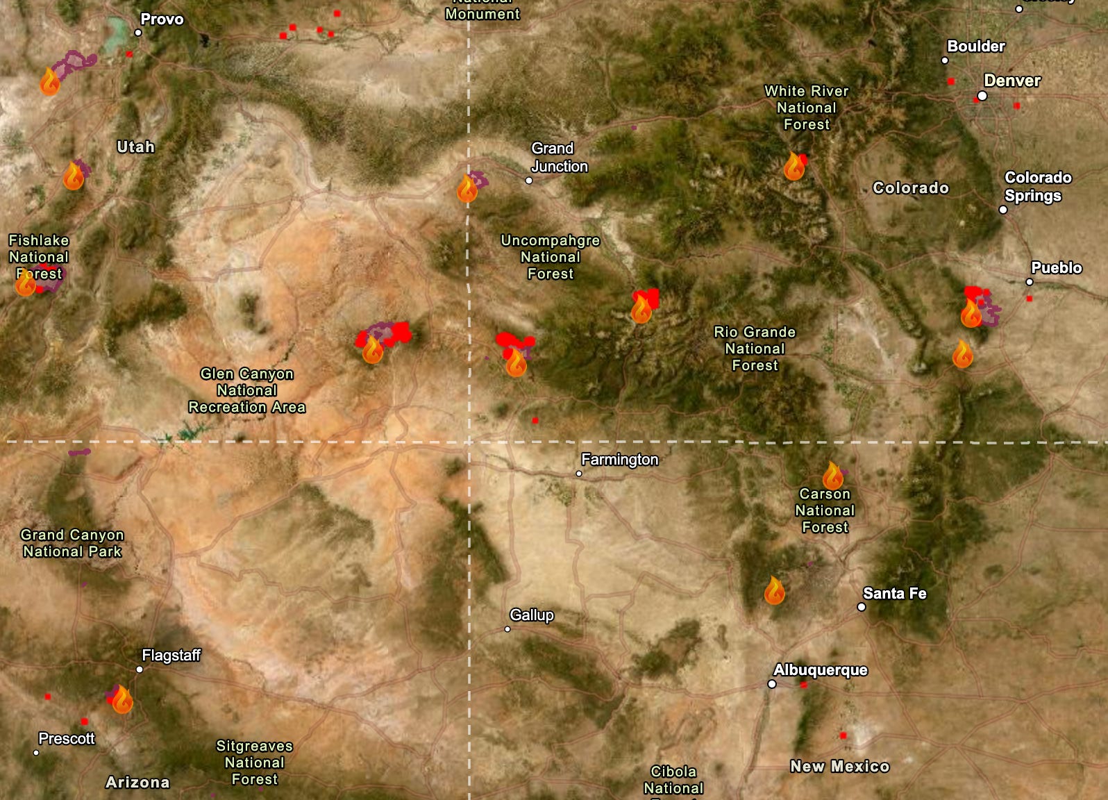
The fire situation in the Four Corners area is not improving. The weather remains hot, dry, and windy, and this week’s forecast calls for more of the same. Next week may even be hotter, if longer-range models hold. Meanwhile, air quality has deteriorated in some places that previously seemed to avoid the worst of the smoke. The good news is that the Fourth of July weekend came and went without any new major fire starts in the region.
So far this year some 37,209 fires have burned through about 3.3 million acres, according to the National Interagency Fire Center. That’s the second highest acreage for the first half of the year in the last decade.
Here’s a rundown of some of the Four Corners area fires. By no means is this a complete list.
The Babylon Fire, burning in the higher elevation parts of Bears Ears National Monument in southeastern Utah, had grown to over 96,000 acres by Monday night, making it the nation’s largest active blaze (the Cottonwood Fire in the western part of the state has gone through about the same amount of acreage, according to Watch Duty). The two are also tied for the fourth largest fires in the state’s recorded history. The Babylon Fire is at 0% containment, with the most active area moving up the west slope of the Abajo Mountains, between Shay Mountain and Mount Linnaeus. Air tankers are pulling water from Lake Powell, and officials are asking boaters to avoid the area between Dangling Rope and Rainbow Bridge.
Closed public lands include: The Needles District of Canyonlands National Park, Manti-La Sal National Forest lands within the Monticello Ranger District, and BLM lands in the Indian Creek Corridor, Beef Basin, Dark Canyon, and the Sweet Alice Wilderness Study Area. Still Open: Natural Bridges National Monument, Cedar Mesa, Grand Gulch, and other lower elevation areas in the southern reaches of Bears Ears National Monument.
The Ferris Fire along the Dolores-Montezuma County line in southwestern Colorado initially burned in a northeasterly direction toward the Disappointment Valley. Then the winds shifted and the most active front of the fire curved back to the northwest, crossing the Ponderosa Gorge of the Dolores River, and is within about 12 miles of the town of Dove Creek. As of Monday night the fire was at 51,622 acres and 22% containment.
The Gold Mountain Fire north of Ouray, Colorado, has burned across almost 29,300 acres of San Juan Mountain high country and was 2% contained as of Monday night. Firefighters on Monday conducted strategic backfiring operations east of Ridgway to provide more protection for structures in that area. There is a chance of thunderstorms this afternoon and evening, which could bring dry lightning along with gusty and erratic winds, with high temperatures reaching the high 80s and low 90s.
The Pocket Fire north of Sedona, Arizona, has reached 26,442 acres and was at 48% containment as of Monday night. Forecasters are predicting more hot and dry weather today, with the mercury topping out around 100° F and sub-20% relative humidity.
⛏️ Mining Monitor ⛏️
On July 6, the Arizona Department of Environmental Quality approved Energy Fuels’ request to amend its aquifer quality permit for a groundwater monitoring well at its Pinyon Plain Mine near the Grand Canyon. The change raises the allowable concentration of arsenic from .050 milligrams per liter to .055 milligrams per liter and the associated alert level from .040 to .050 mg/l.
The Havasupai Tribe strongly condemned the change in a written statement, calling the approval a “profound attack on the Tribe’s inherent responsibility to guard and protect the waters of the Grand Canyon.”
Energy Fuels asked for the revision — and ADEQ granted it — after finding that construction of the mine’s shaft had created a hydraulic sink that allowed naturally occurring arsenic — a known toxic substance — to move toward the facility’s perimeter wells, putting them in violation of their permit.
So, regulators simply altered the permit’s limits and, according to the tribal nation’s statement, “chosen to weaken environmental protections instead of strengthening them.”
Dr. Bradley K. Esser, a retired Lawrence Livermore Laboratory scientist, submitted technical comments on the proposed revision last year. He cast doubt on Energy Fuels’ hydraulic sink explanation, and demonstrated that the arsenic concentrations detected in the monitoring wells are far higher than regional natural background levels. He posited that it was far more likely the elevated arsenic concentrations came from sump water from the mine’s workings contaminating the groundwater.

Esser also writes:
The proposed AQL revision would set a regulatory precedent in which a facility can revise upward the compliance threshold based on a statistical representation of its own rising contamination data, effectively allowing the threshold to chase concentrations. The correct regulatory response to a documented increasing trend is intensified investigation, not threshold normalization.
🥵 Aridification Watch 🐫
Monsoon season officially kicked off in the Southwest in the middle of last month, but it has yet to bring significant amounts of moisture. Earlier forecasts predicting higher than average precipitation beginning later this month are still in place for some parts of the West, but they likely will be accompanied by above-normal temperatures just about everywhere.


'As you might expect, the hot, dry weather is taking a toll on streams around the region. The Animas River through Durango is running at 190 cubic feet per-second; the median flow for this date is over 1,000 cfs.
📸 Parting Shot 🎞️


