Flooding in the Four Corners Country
The San Juan River in Pagosa Springs hits major flood level for the second time in days

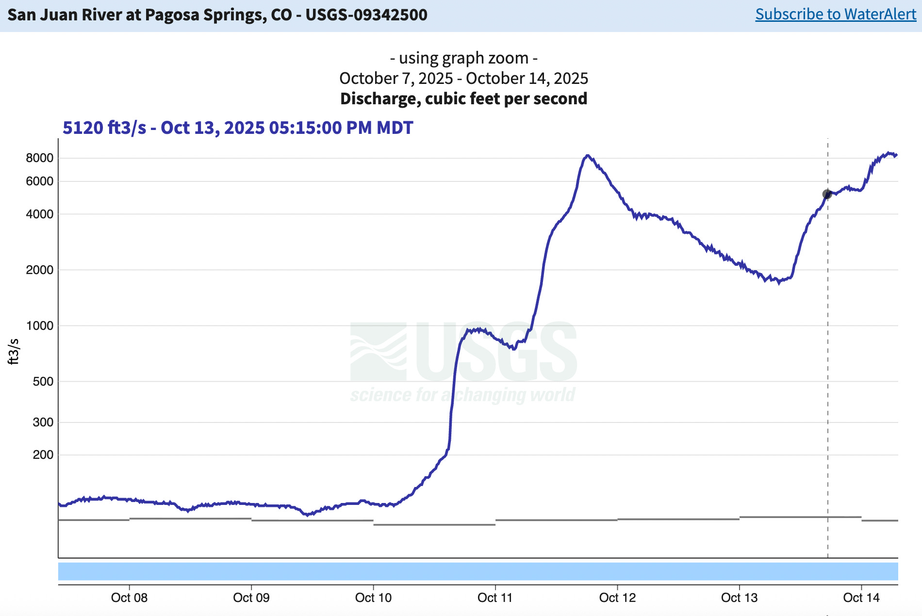
Just after the Southwest suffered through one of the drier summers on record, the remnants of cyclone Priscilla barreled through the region and dumped enormous amounts of rain in the San Juan Mountains and other areas. Previously dry arroyos became raging torrents, and the rivers swelled up and, in many cases, jumped their banks and wreaked havoc and destruction. And it happened not once, but twice — so far — with the first wave hitting over the weekend of Oct. 11, and the second wave underway as I write this on Tuesday morning.
Priscilla favored — if that’s the right word here — the high country, depositing more than four inches of rain during the first wave at Columbus Basin in the La Plata Mountains, more than five inches at the Vallecito SNOTEL station, and more than six inches at Wolf Creek Pass. Interestingly, Molas Pass south of Silverton received “only” three inches during the first wave.

The moisture on Wolf Creek and surrounding areas made its way into the San Juan River, which ballooned into a roiling monster that inundated parts of downtown Pagosa Springs, including sections of the hot springs resort. During the first wave, the river’s flow reached 8,270 cubic feet per second, which was the highest level since the flood of 1927. And during the second wave, it reached a whopping 8,450 cfs.

While today’s high waters pale in comparison to those that raced through Pagosa (destroying homes and infrastructure) in 1911, it is notable that they far exceed those during the flood of 1970, which was the largest flooding to hit the region in more recent memory. Here’s my take on the 1911 flood in Pagosa:
Sixty miles east of Durango, in Pagosa Springs, the upper San Juan River swept away more than 20 structures and destroyed the town water plant, hospital, and jail. Its power plant “was wiped out of existence, nothing left but the water wheel.” The Bayfield Blade called Arboles, a village near the junction of the San Juan and Piedra Rivers, “a thing of the past.” That was a bit of hyperbole, but maybe also prophetic: the community survived that flood, but was later buried under the waters of Navajo Reservoir. Further east the Rio Grande grew even grander and threatened to carry parts of Española, Bernalillo, and Albuquerque down to the Gulf of Mexico.
Clearly all the water will relieve some drought conditions, though certainly not cure them yet. And it is a huge start to the 2026 water year, as can be seen in this graph of accumulated precipitation at Wolf Creek Pass. The station has received 9.9 inches of rain in just two weeks, the highest amount on record.
The San Juan wasn’t the only river to rage. Vallecito Creek above the reservoir hit a mind-blowing 6,980 cubic feet per second on Oct. 11, forcing the evacuation of hundreds of homes in the area. The second wave was substantial, as well, but so far isn’t as extreme as the first wave.
The Animas River through Durango, meanwhile, also grew tremendously, but did not reach flood stage during the first wave, topping out at just under 5,000 cfs. Levels are still increasing as I write this, but it doesn’t appear that they will go much higher this time around. Stay safe everyone!
And, if you want to read more about the history of flooding in the Four Corners Country, check out my long-read from a few years back. I’ve taken down the paywall for a limited time on this one, so everyone can read it — even you free-riders! (And if you like it, maybe you’d consider subscribing).