Feds release Colorado River plan for a warming climate
Also: Are Hovenweep and Aztec Ruins national monuments really in danger of shrinkage?
đ„” Aridification Watch đ«
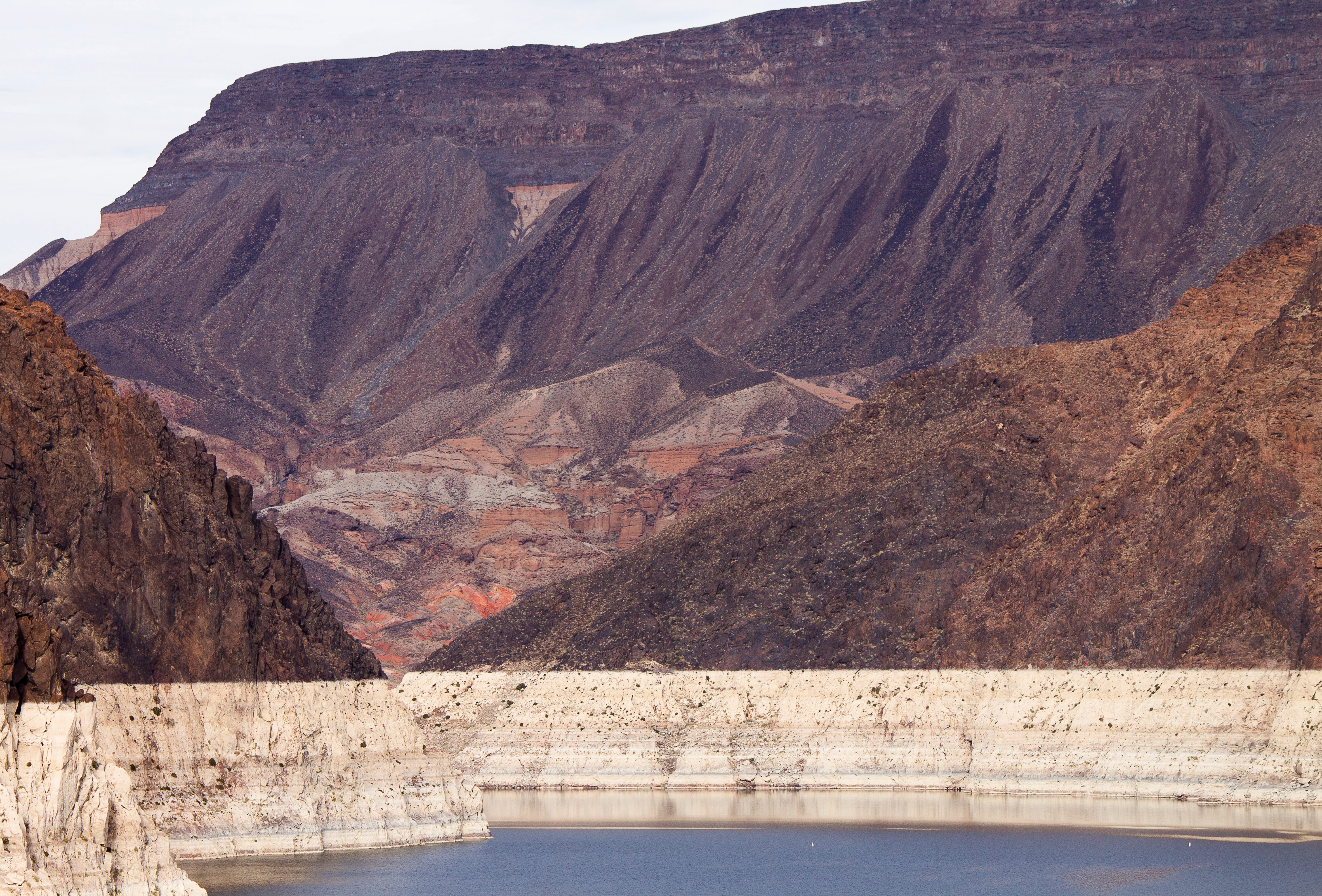
Just over a month before the deadline for the Colorado River states to agree on a plan for sharing the riverâs diminishing waters, the feds released their options, one of which could be implemented if the states donât reach a deal. The Bureau of Reclamationâs âPost-2026 Operational Guidelines and Strategies for Lake Powell and Lake Meadâ offers five alternative scenarios for how to run the river, all of which are aimed at keeping the two reservoirs viable through different methods of divvying up the burden of inevitable shortages in supply.
The document, and the need to deal with present and future shortages, is necessary because human-caused climate change-exacerbated aridification has diminished the Colorado Riverâs flow, throwing the supply-demand equation out of balance. So it is somewhat surreal to peruse the voluminous report that was published by an administration whose leader has called climate change a âhoaxâ and a âcon job.â
My cursory search of the document turned up only one occurrence of the term âclimate change.â1 Yet the authors do acknowledge, if obliquely, that global warming is shrinking the river. âThe Basin is experiencing increased aridity due to climate variability,â they write, âand long-term drought and low runoff conditions are expected in the future.â This tidbit also evaded the censors: âSince 2000, the Basin has experienced persistent drought conditions, exacerbated by a warming climate, resulting in increased evapotranspiration, reduced soil moisture, and ultimately reduced runoff.â
All of the alternatives put most of the burden of cutting consumptive use on the Lower Basin states, while directing the Upper Basin to take unspecified conservation measures. Iâll summarize the alternatives below, but first, it seems telling to see which which proposed alternatives the Bureau considered, but ultimately eliminated from detailed analysis.
The alternatives do not include:
The âboating alternative,â which would prioritize maintaining Lake Powellâs surface level at or above 3,588 feet to serve recreational boating needs. This proposal was put forward in the âPath to 3,588â plan by motorized recreation lobbying group BlueRibbon Coalition. It was dismissed because, basically, it would sacrifice downstream farms and cities for the sake of boating.
The ecosystem alternative, which would prioritize the Colorado Riverâs ecosystem health by focusing management and reducing consumptive human use to protect wildlife, vegetation, habitats, and wetlands.
One-dam alternative, a.k.a. Fill Mead First. This proposal would entail either bypassing or decommissioning Glen Canyon Dam with the aim of filling Lake Mead. The Bureau said they rejected the plan because it would be inconsistent with the Law of the River and might be unacceptable to stakeholders (even though some Lower Basin farmers got a little Hayduke-fever a couple of years back, suggesting that ridding Glen Canyon of the dam might be the best way to manage the river).
Okay, so thatâs whatâs NOT going to happen. So what might happen if the feds feel the need to intervene? Hereâs a very short summary of each alternative:
No Action: This is always offered in these things, and it just means that they would revert back to the pre-2007 interim guidelines era, when releases from Lake Powell were fixed at an average of 8.23 million acre-feet per year and shortages were determined based on Lake Mead levels and would be distributed based on priority.
Basic Coordination Alternative: Lake Powell releases would range from 7 to 9.5 maf annually, based on the reservoirâs surface level, and releases from upper basin reservoirs would be implemented to protect Glen Canyon Damâs infrastructure. Lower Basin shortages (and cuts) would be based on Lake Mead elevations and would be distributed based on water right priority (meaning Arizona gets cut before California).
Enhanced Coordination Alternative: Lake Powell annual releases would range from 4.7 maf to 10.8 maf, based on: a combination of Powell and Mead elevations; the 1-year running average hydrology; and Lower Basin deliveries. The Upper Basin would implement conservation measures to bolster Lake Powell levels if needed, and the Lower Basin shortages would range from 1.3 maf (when Mead and Powell, combined, are 60% full) to 3.0 maf (when Mead and Powell are 30% full or lower) annually. The Lower Basin shortages would be distributed proportionally, meaning that California â which has the largest allocation â would take 49% of the cuts, Arizona 31%, Nevada 3.3%, and Mexico 17%.
Maximum Operational Flexibility Alternative: Lake Powell annual releases would range from 5 maf to 11 maf, based on total Upper Basin system storage and recent hydrology. But when Lake Powellâs surface level drops to 3,510 feet, Glen Canyon Dam would be operated as a ârun of the riverâ facility, meaning that it would release only as much as what it running into the reservoir minus evaporation and seepage to keep the elevation from dropping further. Lower Basin shortages would be on a sliding scale, starting when Powell and Mead drop below 80% full, reaching 1 maf when the two reservoirs are 60% full. When the reservoirs drop below 60%, then shortages would be determined by the previous 3-year flows at Lee Ferry, topping out at a maximum shortage of 4 maf. Shortages would be distributed according to priority and proportionally.
Supply Driven Alternative: This one is based on the amount of water that is actually in the river (go figure!). Lake Powell releases would range from 4.7 maf annually to 12 maf, or about 65% of the 3-year natural flows at Lees Ferry. Lower Basin shortages would kick in when Lake Meadâs surface elevation drops below 1,145 feet, reaching a maximum of 2.1 maf at 1,000 feet and lower. (As of Jan. 12, Meadâs level was 1,063 feet). Shortages would be distributed according to priority and proportionally.

The Lower Basin states reportedly arenât too happy about any of the alternatives, because they put most of the onus for cutting consumption on the Lower Basin. Under the Maximum Flexibility option, for example, Lower Basin shortages could go as high as 4 million acre-feet, or about half of those statesâ total annual consumptive use. And under another, California alone could have to cut up to 1.5 million acre-feet of water use, which could trigger litigation, since California users have some of the most senior rights on the river. Some of the alternatives would potentially nullify the Colorado Compactâs clause ordering the Upper Basin to ânot cause the flow of the river at Lee Ferry to be depleted below an aggregate of 75 maf for any period of ten consecutive years.â
The Bureau does not pick a âpreferredâ alternative, like federal agencies typically do with environmental impact statements, leaving readers guessing about which option or combination of options might be chosen should the need arise. But it also gives more room for the states to reach some sort of agreement to pick an option from the provided list.
* It is found in the Hydrologic Resources section: âWhile the flows in the Colorado River would not affect groundwater in the region, changes to the groundwater systems in the Grand Canyon due to climate change may be an additional environmental factor that affects flows in the Colorado River.â
The snowpack remains dismal in most of the West, and itâs not just because of lack of precipitation. In fact, itâs probably more due to the crazy-warm temperatures. The average temperatures across the Interior were way above normal in November and December, as the map below shows. And Januaryâs similarly unseasonably balmy so far. Yikes.

đ” Public Lands đČ
Last week the new public lands media outlet, RE:PUBLIC, warned readers of âmajor shrinkageâ this year. They meant, of course, that the Trump administration will probably get around to eliminating or eviscerating at least one national monument in the next twelve months. Itâs probably a pretty safe bet, given that in Trumpâs first term he shrank Bears Ears and Grand Staircase-Escalante national monuments, and Project 2025, which the administration has hewn closely to, calls for even more reductions.
Indeed, Iâm surprised they havenât already moved to eliminate some of these protected areas, especially the more recently designated ones like Bears Ears, Baaj Nwaavjo Iâtah Kukveni-Ancestral Footprints of the Grand Canyon National Monument, or Chuckwalla National Monument in California. An optimist might hope that the Trump administration has realized how deeply unpopular this would be, or has come to terms with the fact that the Antiquities Act only allows presidents to establish national monuments, not eliminate them. But I think itâs more likely they were simply too busy dismantling other environmental safeguards â and, for that matter, democracy â to get around to diminishing national monuments.
I was a little surprised by RE:PUBLICâs list of vulnerable national monuments, however. It included Bears Ears et al, which makes sense, but then also speculates about other âlikely targets, due to their proximity to energy and mining interests,â including: Aztec Ruins, Dinosaur, Hovenweep, and Natural Bridges national monuments.
I hate trying to predict what the Trump administration will do in the future, but Iâm going to go out on a limb here and say that these particular national monuments are not in the administrationâs crosshairs. While these protected areas are close to energy-producing areas, and probably have some oil and gas, uranium, lithium, and/or potash producing potential, they simply offer too little to the extractive industries to make it worth the political blowback from eviscerating them.
For those who may be unfamiliar with these places, Iâll take each one individually:
Aztec Ruins: First off, this tiny national monument adjacent to the residential neighborhoods of Aztec, New Mexico, is an amazing place and well worth the visit. The Puebloan structures here are built in the style of Chacoan great houses, and the community â which was established at the end of Chacoâs heyday â may have been become succeeded Chaco as a regional cultural and political center. It is in the San Juan Basin coalbed methane fields and is surrounded by gas wells. In fact, there are a few existing, active wells within the monument boundaries. But no one is champing at the bit to drill any new wells in this region, and they certainly donât need to do so in this tiny monument.
Dinosaur National Monument, in northwestern Colorado, is probably somewhat vulnerable, given its size and proximity to oil and gas fields. But again, thereâs not a whole lot of new drilling going on in the area. It was established in 1915 to protect dinosaur quarries â clearly in tune with the Antiquities Act â so shrinking it would be met with serious bipartisan political pushback.
When Warren G. Harding designated Hovenweep National Monument in 1923 to protect six clusters of Puebloan structures in southeastern Utah from development and pothunters, he strictly followed the Antiquities Actâs mandate to confine its boundaries to âthe smallest area compatible with proper care and management of the objects to be protected.â As such, the boundaries of each âunitâ is basically drawn right around the pueblo and a small area of surroundings, leaving little room for shrinkage. Though it lies on the edge of the historically productive Aneth Oil Field, oil and gas drillers have no need to get inside the boundaries to get at the hydrocarbons. Besides, Trump and Harding have a lot in common, so Trumpâs not likely to want to erase his predecessorâs legacy.
Natural Bridges: Itâs odd to me that this one, which is currently surrounded by Bears Ears National Monument, is included on this list. Yes, there are historic uranium mines nearby, and yes, White Canyon, where the monumentâs namesake formations are located, was once considered for tar sands and oil shale development. But the small monument itself â which was designated by Teddy Roosevelt in 1908 â is not getting in the way of any of this sort of development. Itâs much more likely that Trump would remove the White Canyon area from Bears Ears National Monument, as he did during his first term, potentially opening the area around Natural Bridges back up to new uranium mining claims, while leaving the national monumentâs current boundaries intact.
So, in summary: Donât fret too much about these national monuments getting eliminated or shrunk anytime soon. And for now, maybe we shouldnât worry about any national monument shrinkage. It is possible that Trump wonât go there this term. Trump shrunk Bears Ears and Grand Staircase-Escalante during his first term in part out of spite toward Obama and Clinton, but also to get then-Sen. Orrin Hatchâs legislative support. That the shrinkage also re-opened some public lands to new mining claims and drilling was a secondary motivation.
This time around, Trump has come up with far more generous gifts for the mining and drilling companies, and much more sinister ways to attack his political adversaries. Besides, heâs got his eyes on much bigger prizes â like Greenland.
* The single use of the term âclimate changeâ is found in the Hydrologic Resources section: âWhile the flows in the Colorado River would not affect groundwater in the region, changes to the groundwater systems in the Grand Canyon due to climate change may be an additional environmental factor that affects flows in the Colorado River.â


