Experts: Slash Colorado River consumption ASAP to avoid crisis
Wacky Weather Watch: Tornadoes in Utah; no fruit in Capitol Reef
đ„” Aridification Watch đ«
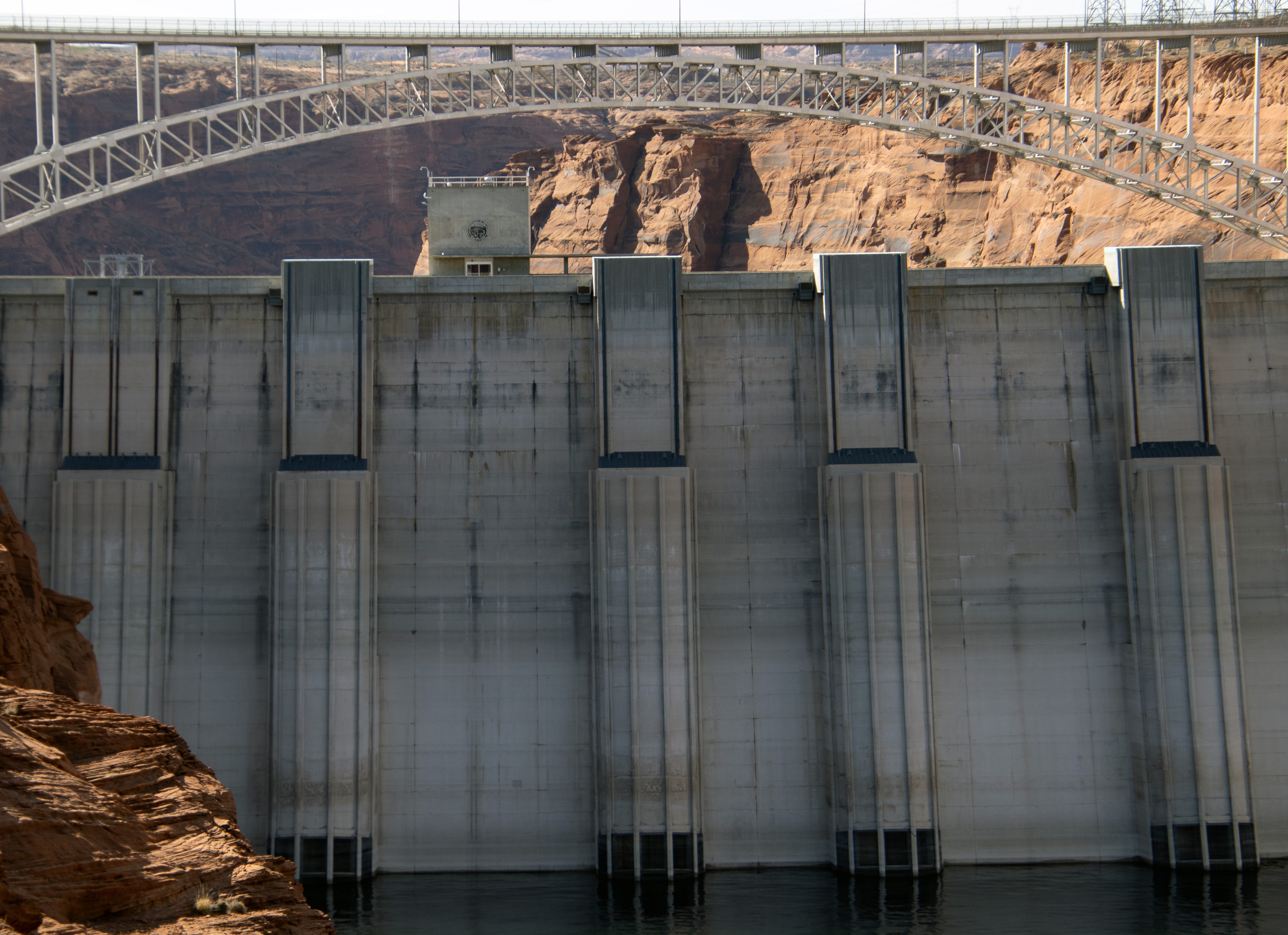
The deadline is rapidly approaching for the Colorado River Basin states to come up with a plan for divvying up the riverâs waters and operating its reservoirs and other plumbing infrastructure after 2026. But a team of experts1 warns that even if the states do make the November deadline â and itâs looking more and more likely they wonât â it wonât be soon enough to avert a crisis in the coming 12 months if the region experiences another dry winter.
Their analysis found that a repeat of the 2025 water year, which ends at the end of this month, will result in consumptive water use in the basin exceeding the Colorado Riverâs natural flow by at least 3.6 million acre-feet. That would potentially use up the remainder of the ârealistically accessible storageâ in Lake Mead and Lake Powell, constraining reservoir operations as early as next summer.
âGiven the existing limitations of the riverâs infrastructure,â they write, âavoiding this possible outcome requires immediate and substantial reductions in consumptive use across the Basin.â
The authors of the paper acknowledge that, despite a plethora of available data, it can be âdifficult to see the water forest amid all the data trees.â Interpreting the data is rife with complexity, and translating snow water equivalents at hundreds of SNOTEL sites into streamflow forecasts is an uncertain science. However, it is abundantly clear that for the last quarter century, the collective users of the Colorado River have consumed more than the river offered, leading to a deep drawdown of the basinâs âsaving accounts,â i.e. Lake Powell, Lake Mead, and a dozen smaller federal reservoirs.
As of Sept. 14, Lake Powell contained about 6.85 million acre-feet of water2, which is less than one-third of what was in the reservoir on the same date in 1999 (23.23 MAF). Lake Mead held about 8 MAF, or 32% of capacity. Equally striking is that in just the last year, Lake Powell has lost about 2.4 MAF of its water â or about 30 feet of surface elevation â to downstream releases and evaporation. The savings account is rapidly draining.
The authors assume that next yearâs natural flow on the Colorado River will be the same as in 2025, or 9.3 MAF3, which they describe as a ârealistic and conservative, but not overly alarmist, projectionâ based on the Bureau of Reclamationâs own forecasts. And, also based on Reclamation reports, they assume total Colorado River consumptive use in the U.S. and Mexico will be 12.9 MAF.
That makes for a deficit of 3.6 MAF that will have to come from the reservoirsâ dwindling storage, potentially putting the elevation of Lake Powell at 3,500 feet by this time next year. And, due to the infrastructureâs limitations, Glen Canyon Dam would have to be operated as a ârun of the riverâ (ROR) facility, meaning it couldnât release more water than is coming into the reservoir at any given time, severely reducing downstream flows in the Grand Canyon and causing an even more rapid drawdown of Lake Mead.
Lake Powell inflows this August totaled about 268,000 acre-feet, while releases were 761,000 acre-feet, meaning under the ROR scenario the monthly release volume would be cut by nearly 500,000 acre-feet. Even more alarming is that instead of sending between 9,000 and 12,000 cubic feet of water per second into the Grand Canyon, late summer streamflows below the dam could fall as low as 2,000 cfs, affecting aquatic life and making river running significantly less predictable (and more like the pre-dam days4, save for the amount of sediment in the water). Iâd be curious to see Crystal rapid or Lava Falls at 2,000 cfs. Any insight on that one would be appreciated.

While this scenario could be delayed by essentially draining upstream reservoirs such as Flaming Gorge in Utah and Wyoming or Blue Mesa in Colorado, it would only offer a temporary reprieve. Two consecutive dry years would certainly render Glen Canyon Dam essentially useless, and leave Lower Basin users high and dry. Which leaves the folks relying on the river with a couple of choices: They can pray for a lot of snow and hope someoneâs listening, or they can slash consumption significantly and rapidly.
âïž Wacky Weather WatchâĄïž
Not just one, but two tornadoes hit San Juan County, Utah, over the weekend, and when I say tornadoes, I mean honest-to-god twisters of the kind you normally see in the Midwest, not in the Four Corners region. In fact, one of them wrecked three houses and damaged others in the Montezuma Creek area, according to a Navajo Times report, while another touched down south of Blanding and destroyed or damaged homes, trailers, and a hay barn. While there were no reports of human injuries, but an unknown number of pets and livestock went missing during the event.
The tornadoes were part of a series of late-season monsoonal storms that hit the region, bringing downpours, increasing streamflow, and leaving some mountain peaks white with a dusting of snow. The stormsâ effects varied across the region. Flows in the San Juan River in Pagosa, for example, shot up from around 100 cfs to over 1,000 cfs in a matter of hours before falling back down again almost as rapidly, whereas the Animas River in Durango jumped up to almost 600 cfs and plateaued for a few days. Itâs the latter, more sustained increase that could give Lake Powell a much-needed bump, although it wonât mean much without a lot of snow this coming winter.

***
Well this is a bummer: Thereâs no fruit in the Fruita Historic District orchards in Capitol Reef National Park this year.
The orchards sit in the lush valley of the Fremont River under the watch of desert varnished Wingate sandstone cliffs, and typically the trees produce cherries, plums, peaches, almonds, pears, apples, quince, walnuts, mulberries, nectarines, and apricots that are free for the picking. The folks at the Gifford Homestead store even make and sell outrageously good pies using said fruit (I think I may have eaten more than one pie last time I was there).
But this spring âan unusual warm spell began the bloom at the earliest time in 20 years,â according to Capitol Reef National Parkâs climate webpage. âThe warmth was interrupted twice by nights that plummeted below freezing. This temperature whiplash froze even the hardier blossoms, causing a loss of over 80% of the yearâs fruit harvest. Climate change threatens this bountiful, interactive, and historical treasure.â
That sucks, but I have to say Iâm pleasantly surprised that the National Park Service still has this sort of climate-related information on its website, and that it is even allowed to use the word âclimateâ these days.
đ Good News Corner đ
Yes, there are some bright spots in these dark times. One of them is shining out of Californiaâs Central Valley, where the Turlock Irrigation Districtâs solar-over-canal installation is now online. The project is exactly what it sounds like: An array of photovoltaic panels spanning an irrigation canal. One portion is 20 feet wide, the other 110 feet, and the system has a capacity of 1.6 megawatts, which isnât huge, but itâs enough to power pumps and other equipment.
The California installation follows a similar installation built by the Gila River Indian Community in Arizona last year. Both are scene as test cases that could open the door to much larger, utility-scale arrays.
The arrays not only generate power, but also shade the canals, reducing evaporation. Best of all, the canals are a low-conflict site for solar, and donât require scraping any deserts of vegetation or messing up neighborsâ views, though it could restrict fishing â if looking to land a catfish or something from a cement-lined waterway is your sort of thing.
Thereâs really no reason all of the canals in California and Arizona couldnât be covered with solar. Yes, there are transmission constraints, and some areas would have to remain uncovered for access and maintenance, but still. And while weâre at it, why not put the panels over parking lots and on top of big box stores and reclaimed coal mines and, well, you get the picture.
***
Also in the cool news department: Navajo entrepreneur Celesta Littlemanâs Sunbeam Tours and Railway is working to convert the old electric railway that hauled coal from Black Mesa to the Navajo Generating Station into a track for zero-emissions electric rail vehicles for tourists, sightseers, and anyone else that wants to travel the scenic route.
Analysis of Colorado River Basin Storage Suggests Need For Immediate Action, by: Jack Schmidt, Director of the Center for Colorado River Studies at Utah State University; Anne Castle of the Getches-Wilkinson Center at CU Boulder and former U.S. Commissioner of the Upper Colorado River Commission; John Fleck, Writer in Residence at the Utton Transboundary Resources Center at the University of New Mexico; Eric Kuhn, Retired General Manager of the Colorado River Water Conservation District; Kathryn Sorenson, of the Kyl Center for Water Policy at Arizona State University and former Director of the Phoenix Water Services; and Katherine Tara of the Utton Transboundary Resources Center.
This is the total amount of water backed up behind Glen Canyon Dam. But this is not all available for use due to the damâs infrastructure and the need to keep the water level above minimum power pool so that water can continue to be released via the penstocks and hydroelectric turbines. Thereâs actually only about 2.7 million acre-feet of ârealistically accessible storageâ in Lake Powell and 3.6 MAF in Lake Mead (as of 9/1/2025).
This includes 8.5 MAF natural flow at Lees Ferry, plus about .8 MAF from springs and tributaries running into the river between Lees Ferry and Hoover Dam.
For months after the dam was first completed, managers released a relative trickle at times, with daily flows at Lees Ferry dropping as low as 700 cfs in 1963 and lower than 1,000 cfs on many occasions in the sixties. And prior to the Grand Canyon Protection Act of 1992, when minimum daily releases were implemented, managers sometimes released as little as 1,300 cfs from the dam at times to try to maintain reservoir levels.