Deadpool Data Dump: The Western water situation is dire

💀 Deadpool Data Dump 🌊
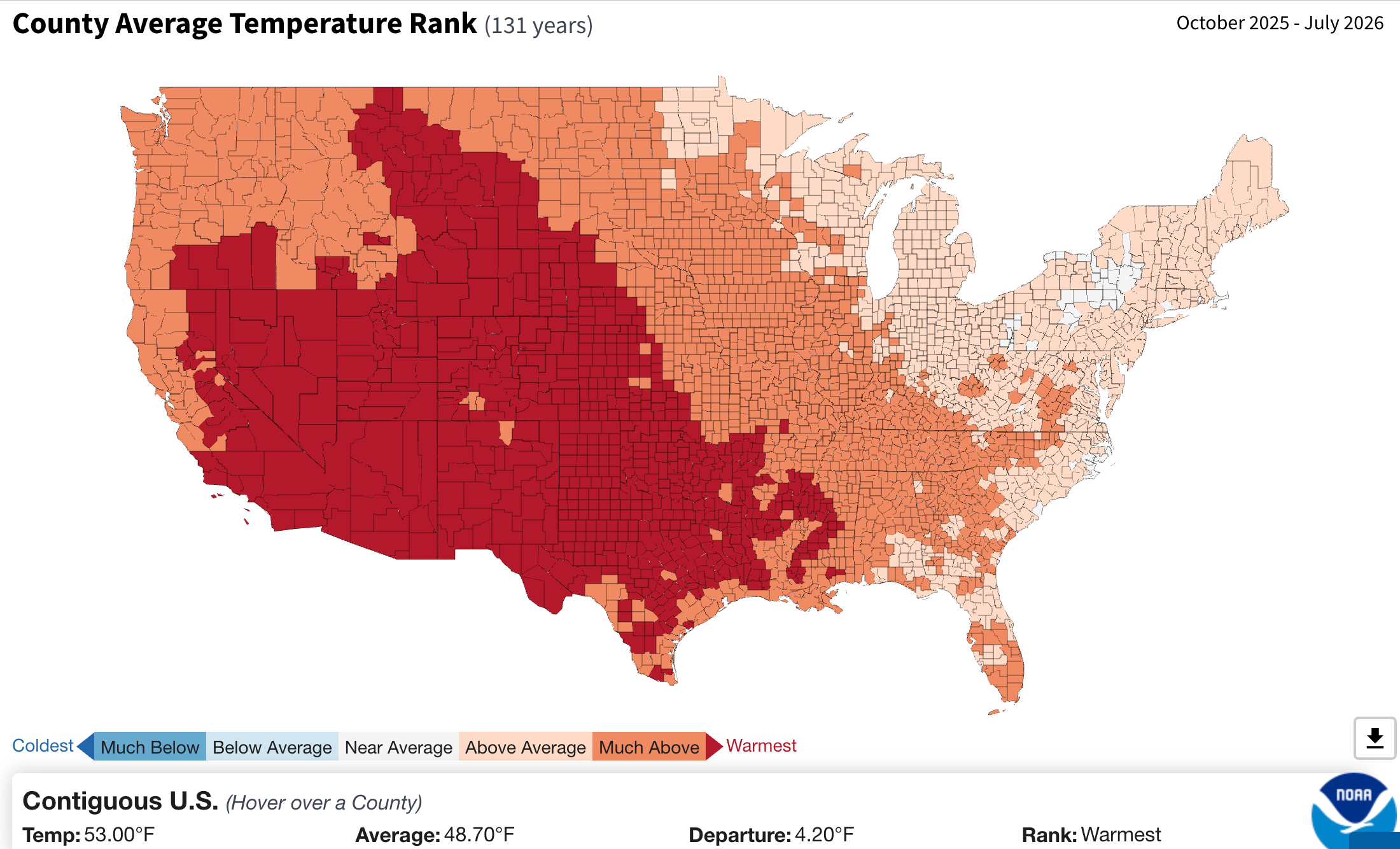
No, Lake Powell’s not that close to actual dead pool — or the level at which water can no longer be released downstream. At least not yet. But it is now within 20 feet of de facto deadpool, or 3,500 feet, which is the surface elevation the feds have said they will “defend” to keep Glen Canyon Dam viable. Besides, in this case I’m using “deadpool” somewhat metaphorically to describe the current state of water on the Colorado River and the rest of the West, which is about as dire as “deadpool” sounds.
It’s normal for streamflows to drop in August as the last remnants of high-country snow disappear in the dog-days sun. But since most of the snow was gone by late June, and the monsoon has thus far dropped in only for brief, violent, and occasional visits, almost every creek and river in the West is flowing far below median levels for this time of year. The water is also unusually warm, which is bad for fish. The Animas River in Durango, for example has climbed up into the 70° F territory every day for the last several weeks.
In the Upper Colorado River Basin, irrigation ditches with junior water rights are getting shut down right and left, weeks earlier than normal and just ahead of the big harvesting season. It’s already been a tough summer for most farmers; if reliable rains don’t arrive soon it could get much worse.

One of the scariest dry-time indicators of the summer so far was the Colorado River near Palisade, Colorado, which fell to 43 cubic feet per second in early August. To put that in context, McElmo Creek, which is basically a desert arroyo fed by irrigation runoff, has been running around 30 cfs for the last few weeks.
It’s important to note, however, that it’s not only drought, but also diversions, that are depleting the Colorado River. The river below Glenwood Springs, which is upstream of Palisade, has been running around 1,700 cfs. And major ditches — Cameco, Orchard Mesa, and Grand Valley canals — that pull water from the Colorado just upstream from the Palisade gage are together carrying some 2,000 cfs, meaning they are taking nearly all of the river’s water. Runoff from those ditches eventually runs back into the Colorado, bringing its flows back up somewhat before the river crosses the state line into Utah.

The good news is that rains have started up again in southern Arizona (the National Weather Service’s Tucson office has issued a flash flood watch for tomorrow), and forecasters are predicting thunderstorms will be returning to the rest of the region soon. Hopefully they’ll bring nice, gentle, soaking moisture, and not just lightning and torrential flooding.
But let’s get back to our Lake Powell August update and some numbers:
3,520.8 feet: Surface elevation of Lake Powell on Aug. 10, 2026. This is still about 9 inches higher than the previous all-time low of 3,519.9 in April of 2023. But that was April and there was already a bunch of snow in the high-country that would soon boost reservoir levels. The reservoir has been declining at a rate of about 2 inches per day, but that’s likely to speed up unless there is significant upstream precipitation in the coming weeks. So it’s not far-fetched to think it will drop to 3,500 feet as soon as this October.
2,505 cubic feet per second: Lake Powell’s inflow on Aug. 10, 2026.
-387 cfs: Lake Powell’s unregulated inflow on Aug. 8, 2026. Yes, that is a negative number, which may seem impossible. But unregulated inflow is an estimate of what the inflows would be without supplemental releases from upstream dams. Which means that valuable water is being released from upstream dams to slow Lake Powell’s decline.
7,710 cfs: Total average daily release from Glen Canyon Dam on Aug. 10, 2026.
281,267 acre-feet: Total inflows in July 2026.
83,824 acre-feet: Total unregulated inflows in July 2026 (meaning nearly 200,000 acre-feet was released from upstream dams to supplement the flows).
24,164 acre-feet: Estimated evaporation from Lake Powell in July 2026.
482,092 acre-feet: Total releases from Glen Canyon Dam in July 2026.
-224,989 acre-feet: Lake Powell’s water deficit in July 2026 (inflows - evaporation - releases = deficit)
-422,432 acre-feet: Lake Powell’s water deficit using unregulated inflow (or what it would be without supplemental water from upstream reservoirs).
3.72 million acre-feet: Total Lake Powell inflows so far this water year. At this pace, the 2026 water year’s total inflows will be around 4.2 MAF.
159 acre-feet: Total cool mix releases from Glen Canyon Dam in July 2026. This is where cooler water is released through the river outlet tubes — bypassing the hydropower turbines — to stifle smallmouth bass reproduction downstream of the dam. These releases have become necessary because during low reservoir levels, the warm-water loving bass are more likely to get sucked through the dam into the river, where they compete with and prey on native fish and stocked trout. But the Associated Press reports that the Bureau of Reclamation will not be doing any cool water mixing this year, since it would further reduce already diminished hydropower production from the dam (I’ll dig deep into the hydropower issue in this Friday’s Land Desk dispatch).
It’s not just Lake Powell that’s being drained, of course. During July, Flaming Gorge Reservoir ran an 87,000-acre-feet deficit; Blue Mesa Reservoir ran a 55,000 acre-feet deficit (and it received supplemental inflows from Taylor Park Reservoir); and Navajo Reservoir ran a 77,000-acre-feet deficit. Meanwhile, downstream, Lake Mead’s surface level fell to 1,040.2 feet, which is an all-time low. Deadpool watch, indeed.
🔥 Wildfire Lookout 🔥

The wildfire situation in the West is just insane right now. It seems that every time one big blaze starts to die down and reaches containment, another one pops up and grows even larger. Under the Trump administration’s full-suppression regime — which seeks to extinguish every fire, even those in wilderness that don’t threaten homes or lives — it all becomes a giant and deadly game of whack-a-mole.
In Utah, for instance, the Cottonwood Fire reached 95% containment after burning through more than 97,000 acres; the Babylon Fire in Bears Ears National Monument then grew to 107,000 acres before being contained; and now the Widemouth 2 Fire has exploded to 121,226 acres, and has taken the lives of two firefighters aboard a helicopter that crashed this past weekend.
The Northwest is especially scary, with over 2 million acres burned so far this year. Current fires include the Big Grass Fire straddling the southern Oregon-Idaho border that had burned through more than 541,000 acres as of Monday morning; the Rowe Creek Complex northeast of Bend, Oregon, at 368,000 acres; the Grasshopper Fire, on the east slopes of Mt. Hood; and the Little Giant and Sinlahekin Fires in Washington, at 111,000 and 143,000 acres, respectively.
A small sampling of other active fires in the West:
The Bug Fire and Fred Mtn. Fire are burning along the California-Nevada border just north of Reno, and are forcing evacuations.
The Gold Mountain Fire in the San Juan Mountains north of Ouray, Colorado, is at 90% containment after burning nearly 40,000 acres. But to the east of it, the Elk Fire jumped in size to over 7,000 acres, and is forcing evacuations in Hinsdale County.
The Frijoles Fire in northern New Mexico east of Pojoaque blew up to 4,158 acres over the weekend, and is at 0% containment. It is burning in the Pecos Wilderness Area.


