š„µ Aridification Watch š«
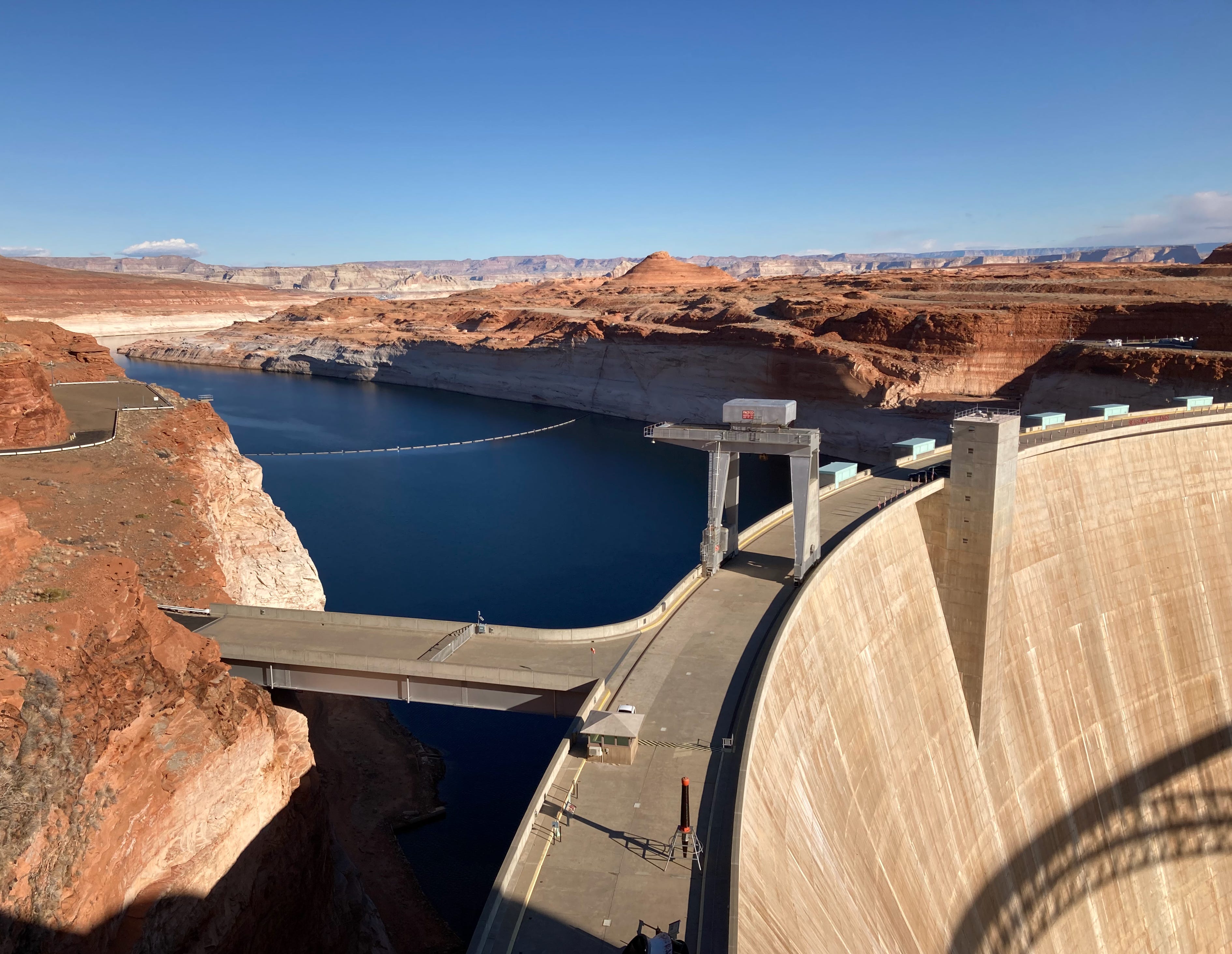
The Bureau of Reclamation recently released its August 24-month study of the Colorado River, its projected water supplies, and the effect on reservoir levels and water cutbacks. Itās a doozy that, according to the Bureau, reaffirms the āimpacts of unprecedented drought,ā and necessitates continued water-use reductions for Arizona, Nevada, and Mexico.
Thing is, it may actually be even worse than the feds predict.
Hereās the chart for Lake Powell, showing reservoir levels for July, and projected levels for the maximum, minimum, and most probable inflow scenarios. Check it out:
A couple of details struck me right off the bat. The first is that in order for the maximum scenario to come to fruition, there would have to be a big surge of flow in the Colorado River upstream from Lake Powell in October, November, and December (see how the blue line departs from the others in October?), followed by a massively snowy winter. Itās possible, but seems pretty unlikely, given that inflows and water levels almost always drop in the fall and winter.
The second is that even in the minimum flow scenario, they are predicting that next yearās spring runoff will increase lake levels by about eight feet, whereas this year the runoff only boosted the level by four feet. So even the worst case scenario is better than the most recent reality. For the most probable scenario to work out, meanwhile, this coming winter would have to be far snowier than this past one ā possible, but I wouldnāt bank on it.
Now, I donāt really know what Iām talking about here. But John Fleck, Anne Castle, Eric Kuhn, et al, most certainly do. And they wrote a piece warning that the Bureau of Reclamationās forecasts historically tend toward the optimistic. āWhatever you see in Reclamationās report of the āMost Probableā reservoir levels for the next two years,ā they write on Fleckās Inkstain blog, āwe must prepare for things to be much worse.ā
They remind readers that last year, Reclamation predicted Lake Powell would most probably be up to 3,593 feet above sea level by the end of this July. In fact, it was at 3,555 feet (and has dropped another four feet since then). So, yeah, Rec was way the heck off, and it certainly wasnāt the first time. Fleck and company say this is because the study does not āfully capture the climate-change driven aridification of the Colorado River Basin.ā
This all matters because Reclamation bases water deliveries and cuts on these studies. And if they have an āoptimistic bias,ā then it could affect planning, and may lead to Lake Powellās levels dropping far faster than predicted, which could in turn lead to another āChallenge at Glen Canyonā a la 1983, albeit due to too little water rather than too much.
It has once again prompted the Utah Rivers Council, Glen Canyon Institute, and Save the Colorado to call for the feds to overhaul the river outlet tubes and provide a bypass outlet for Glen Canyon Dam that will allow water to be released safely when levels drop below the minimum power pool.
It always began with a hot summerās day in late July or early August. The sun beating down from a cloudless noontime sky, the high growl of lawnmowers harmonizing in the distance, the pungent smell of freshly cut grass. Stillness. Maybe a bit of loneliness, too, as the other neighborhood kids are off at their other parentās house, or at summer camp, or whatever. Maybe my brother will take me fishing with him. Put the worm on the hook, toss it into the murky pool upstream from the bridge, grow impatient and decide to catch the little bullheads instead. Mottled sculpin, actually. The riverās low this time of year, low enough to drag an old log in and ride it downstream for a bit till it bucks us off and we scramble to stand up on the slippery rocks in the current, and thatās when we notice the sun is not so bright and look up to see towering thunderheads all billowy above Smelter Mountain and the breeze kicks up prickly sand and throws it at us and suddenly itās not hot anymore and itās time to get home before the rain and the lightning, even though our jeans and shirts and TG&Y sneakers are soaking wet already.
We jog through the park and up the hill and another block to the house and I stay out in the yard to await the storm. The wind bends the big maple and elm and ash trees, threatens to tear another branch off the old apricot, rushes through my hair. The sky, now, is dark grey, almost cobalt blue. A flash of lightning ⦠one-one-thousand, two-one-thousand, three ā- boom! Itās getting close. And then the first drop of rain hits my outstretched hand, big and cold, and I run onto the porch to revel in the petrichor and the tempest to come.
It is the monsoon season in the Southwest, which, once upon a time, meant that a violent thunderstorm would arrive every afternoon, bringing huge amounts of precipitation in a short period of time, perhaps in the form of hail or sleet, leading to gully busters and flash floods and overflowing gutters and a spike in the riverās flow. Then the clouds would move on, the sun would return for the last hour or two of the day, and steam would rise from the pavement, giving the arid town a glimpse of sultriness.
It has always been my favorite time of year, especially in Durango and the Animas Valley. Thereās just something about the combination of colors: The slate-blue sky against the desert-varnish-striped Entrada sandstone against the deep red Cutler and Chinle formation against the emerald green of irrigated hayfields. And the weird patterns the storms follow as they move through the valley. Downtown can be deluged, while just north or south of town stays bone dry.
But then, each part of the West is special during the monsoon: The mountains are downright frightening, especially when youāre rushing to summit a peak before the storm and you look over to see your companionās hair standing on end. Canyon Country can be a blast, so long as youāre in an elevated area where you can watch the water spill off sandstone cliffs and race through sandy arroyos and you donāt have to drive back across that arroyo to get to work or something. And down in Tucson and Phoenix it often provides extra excitement in the form of dust clouds, then crazy lightning and thunder displays, followed by torrents that provide a bit of relief from the searing heat.
This year, however, the monsoon has so far failed to arrive. In fact, over the last decade or so, it seems to have been far less reliable generally than it was in my youth. Memory, however, is fallible, especially when it comes to recalling weather patterns from the distant and even not so distant past. So I checked the records, and they verify that Iām not totally fabricating things here.
Durangoās online records only go back to 2000, so they donāt do me much good. Instead, I relied on Mesa Verde National Park, which has records back to the 1920s (but tends to be drier than Durango). Based on a random sampling from each decade, it would appear that the monsoon nearly always delivers in parts of July and August, with normal monthly precipitation totals of 1.4ā and 2.05ā respectively. However, my memory of nearly daily storms was off: Even way back when I was a kid, it only rained every three days or so, sometimes less often. Meanwhile, the more recent past hasnāt been quite as bad as I thought. The July-August precipitation totals were below normal for six of the last ten years, and above normal during the other four. Not great, but not catastrophic.
Still, August is more than halfway over and the two month total so far is only .27ā of precipitation, all of which fell in July.
***
The result, naturally, is lower-than-normal streamflows (which were already down due to the lack of snow last winter and above-normal temperatures). This isnāt only bad for us terrestrial water users, but also harms fish and other aquatic life, especially when accompanied by high water temperatures. The Yampa River in northwestern Colorado, for example, is running at just 56 cubic feet per second at the USGSās Deerlodge Park gauge, which is not good. But more concerning is that the water temperature has been shooting up to 81° F during the day. Trout start to struggle at around 70°.
š«£ Correction š
Remember the Monkeywrenching essay I wrote last week? I have been informed by a very reliable source, eyewitness, and possible accomplice ā who will remain anonymous, of course ā that I was wrong about my father and companions burning a single billboard near Silverton. Hereās how it really unfolded:
āAs I remember the great billboard caper, there were 5 or 6 of them along the Champion cliffs, destroying that nice view of Silverton. Allen Nossaman railed against them. And they weren't burned, but knocked down and slung over the edge of the cliff. And not only did we get away with it, as far as we heard, not a sole, including Nossaman, noticed that they were gone.ā
So there you have it, folks!
Yeah⦠all those data centers and housing developments on public land? Riiiiight