The Land Desk

Share this post
Aridification Briefs: Spring runoff edition
www.landdesk.org

Aridification Briefs: Spring runoff edition

Plus: Utah lawmakers approve Bears Ears NM land swap

Jonathan P. Thompson
May 20
4
1
Share this post
Aridification Briefs: Spring runoff edition
www.landdesk.org
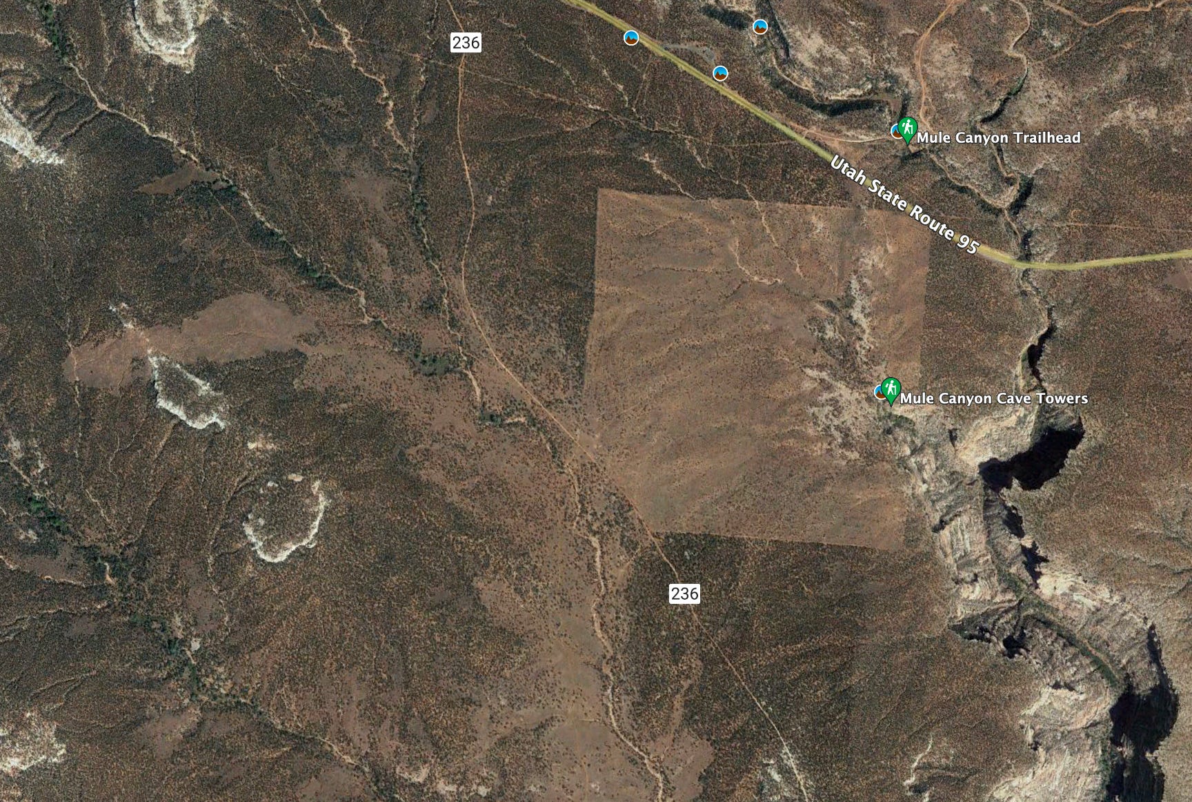
On Cedar Mesa, state land parcels are often identifiable by the fact that they have been chained, i.e. the trees have been wiped out to make way for forage for livestock grazing. This state-owned parcel sits within Bears Ears National Monument and will be transferred to federal management when the land exchange goes through. It includes the Cave Tower site, a Pueblo village on the rim of Mule Canyon. Google Earth image.

The News: Utah state lawmakers approved a land swap that would transfer 161,000 acres of Utah School and Institutional Land Trust Administration lands currently within Bears Ears National Monument to the federal government, and 164,000 acres scattered around the state to SITLA. The deal mirrors a similar one that followed the creation of Grand Staircase-Escalante National Monument. Congress must also approve it.

The Context: When Utah became a state, it was sliced up into six-mile-wide square townships under the Public Lands Survey System, each of which were then divided into 36 sections. The federal government granted four sections of each township to the State of Utah, checker-boarding the vast expanses of public land with over 3 million acres of these squares of land, which SITLA now can sell to private parties, lease out to drilling, mining, or grazing interests, or develop itself.

About 170 of those SITLA squares were scattered across the 1.35 million acres contained by the original Bears Ears National Monument. Monument opponents seized on that fact to justify obliterating or shrinking the new monument. In early 2017, Sen. Orrin Hatch, a staunch Republican, said, “The county schools have been strapped for cash ever since the Bears Ears Monument designation, because that designation rendered this land useless.” 

It made for an outrage-inspiring talking point, and a false one. Hatch, who retired in 2018, was either blatantly lying or is woefully ignorant of how SITLA lands and national monuments work. 

First off, the designation in no way rendered the lands useless: The state retained control over the land and its ability to lease or sell the parcels in question. Secondly, revenues from state land parcels go to a statewide pot, regardless of which county they are in (so even if all of San Juan County’s parcels were nullified, it would have minimal effect on the county’s schools). And thirdly, the monument designation was actually a gift to Utah’s schools and institutions because it set the stage for a lucrative land exchange that will net SITLA hundreds of millions of dollars more than they would have brought in from the Bears Ears parcels, most of which had next to zero revenue-generating potential. 

SITLA will give up its Bears Ears parcels, as well as some land in the Bonneville Salt Flats, in exchange for Bureau of Land Management parcels in San Juan and Grand Counties and further afield. The SITLA Bears Ears parcels include significant cultural sites such as Cave Towers, as well as parcels currently leased for livestock grazing, some of which contain corrals or stock ponds. Grazing will be allowed to continue, but the parcels will be closed to mining claims, oil and gas leasing, or other development. (Map of the proposed parcels).

The parcels SITLA obtains outside the monument will become like other state trust lands: open to leasing and development, without the federal protections they now have. That has raised concerns. Residents and officials in Grand County, home of Moab, worry about potential development on parcels located in popular recreation areas. A lot of parcels are in the Lisbon Valley area, which was historically a uranium-mining hotspot and is now home to a big copper mine that is looking to expand—the exchange could facilitate that. And a cluster of the soon-to-be-SITLA squares is at Shootaring Canyon near the southern foot of the Henry Mountains, where an idled uranium mine and mothballed mill are currently located.

Twitter avatar for @SouthernUTWildSouthern Utah Wilderness Alliance @SouthernUTWild
This land swap is clearly going to result in better management for sacred & cultural sites within the monument. However, the devil will be in the details; we are concerned about some of the lands that School Trust Lands proposes to acquire in the exchange.
Utah lawmakers approve Bears Ears land swapIt took only a few minutes for legislative leaders to unanimously approve a massive land swap involving the controversial Bears Ears National Monument.wildutah.info

May 18th 2022

2 Retweets2 Likes

Bears Ears National Monument opponents urged SITLA to hold off on the exchange, fearing it would validate the monument and the current boundaries even as Utah Republicans continue to challenge the monument designation in court.


Aridification Watch

Ooof. Ouch. Gasp. Ugh.

That’s the nut graf of today’s news briefs. Just a few months ago, we were feeling somewhat optimistic about how the water year was shaping up. The snow was pretty deep in the high country, the cross country skiing was fabulous in February, and the snow kept coming in early March.

But there was a problem. Okay, a few of them. One is that the late February and March snowstorms were accompanied by a fair amount of dust, much of which ended up coating the snow, especially in the southern San Juan Mountains. As we’ve discussed before, dust reduces albedo—or the snow’s ability to reflect the sun’s rays—which causes it to absorb more heat and melt or sublimate faster. That, together with warm spring temperatures, a fairly dry April, and relentless winds conspired to diminish the snowpack at a frighteningly fast rate.

The result: In mid-March, southwest Colorado snowpack levels were sitting right around average. By mid-May, the snow had vanished completely in some basins, far earlier than “normal,” whatever that means anymore. Here are some of the results of the fast melt, the warm temperatures, and the accumulated effects of two decades of megadrought:

  • Snow levels at SNOTEL stations in the Animas River Basin and the Rio Grande Headwaters looked okay in mid-March. Then it plummeted. Both have melted out much earlier than last year—and almost at the same time as in 2002. Ack.

  • Spring runoff on the Animas River in southwestern Colorado appears to have peaked rather early, hitting 2,970 cubic feet per second on May 16. That’s about three weeks earlier, and 300 cfs less, than last year, and almost identical in volume and timing to 2013, which was a dismal water year.

  • Dry + hot + wind = fire danger. The Plumtaw fire is burning near Pagosa Springs, Colorado.

    Twitter avatar for @kwfrickeKevin Frickē @kwfricke
    Critical fire weather expected on the Plumtaw Fire today
    pagosasun.com/2022/05/19/cri… via @the Pagosa Springs SUNCritical fire weather expected on the Plumtaw Fire today | The Pagosa Springs SUNMay 19, 11:30 a.m. update: The Plumtaw Fire is burning 7 miles north of Pagosa Springs. An evacuation notice is still in place for the Lost Valley of the San […]pagosasun.com

    May 19th 2022

  • The fires in New Mexico are just going crazy. The growth of the big one, the Hermits Peak Fire, slowed somewhat, even as the Black Fire, in the Gila National Forest, exploded, growing to 93,000 acres over several days. As of May 20, 468,199 acres had burned in major New Mexico wildfires this year. That’s about four times more than burned during all of 2021 and 50,000 acres more than burned in New Mexico in 2002. Reminder: Summer hasn’t begun!

  • Last June, Durango resident and land and water appraiser John Norton headed into the Needles range in southwestern Colorado and found, at 13,000 feet in elevation, very little snow and parched soil and vegetation where, a few decades ago, one would have encountered lush tundra, snowfields, and summer rains “so abundant, they were almost annoying.” He and Michael Preston, also a longtime resident who has been deeply involved in water issues in the Southwest, decided to see whether the data correlated with their memories. They wrote up a report on their findings: “Trends in temperature, precipitation and runoff in the San Juan Mountains: 2000-2021.” It’s a fascinating and disturbing read. They discovered:

    • Over the last two decades, the average annual temperature in the San Juans has increased by 3.6° F and precipitation has decreased by 7 inches, or 19%;

    • Winter precipitation has actually increased, but was more than offset by decreases in the spring, summer, and fall;

    • Combined annual runoff in 18 major streams declined by more than 1 million acre feet, a 26.9% decrease.

    • The report is chock full of graphs and charts breaking these findings down. It’s worth a look for everyone who is concerned about the climate and the incredible shrinking snowpack and rivers. Read it here.

  • And then there’s Lake Powell, where the prognosis just keeps getting grimmer:

    Twitter avatar for @zak_podmoreZak 🦦 Podmore @zak_podmore
    The forecast was just updated to project 3.5 million acre feet will end up in Lake Powell this year, down 300 KAF from May 1 and down 1 MAF from the Feb forecast.
    Image

    Zak 🦦 Podmore @zak_podmore

    Do any water experts know why we didn't get an official forecast update from the Colorado Basin River Forecast Center on May 15? https://t.co/0FjjeuQsUT

    May 18th 2022

    2 Retweets8 Likes

1
Share this post
Aridification Briefs: Spring runoff edition
www.landdesk.org
1 Comment

Create your profile

0 subscriptions will be displayed on your profile (edit)

Skip for now

Only paid subscribers can comment on this post

Already a paid subscriber? Sign in

Check your email

For your security, we need to re-authenticate you.

Click the link we sent to , or click here to sign in.

Maggie/NYS
May 20

Only read the first part of this post about the Bears Ears swap. Why is it necessary for the livestock grazing to "continue" IN the monument? Livestock is a damaging entity as was the whole mining thing. Cant these allotments be retired? (I'll read the rest shortly)

Expand full comment
ReplyCollapse
TopNewCommunity

No posts

Ready for more?

© 2022 Jonathan P. Thompson
Privacy ∙ Terms ∙ Collection notice
Publish on Substack Get the app
Substack is the home for great writing