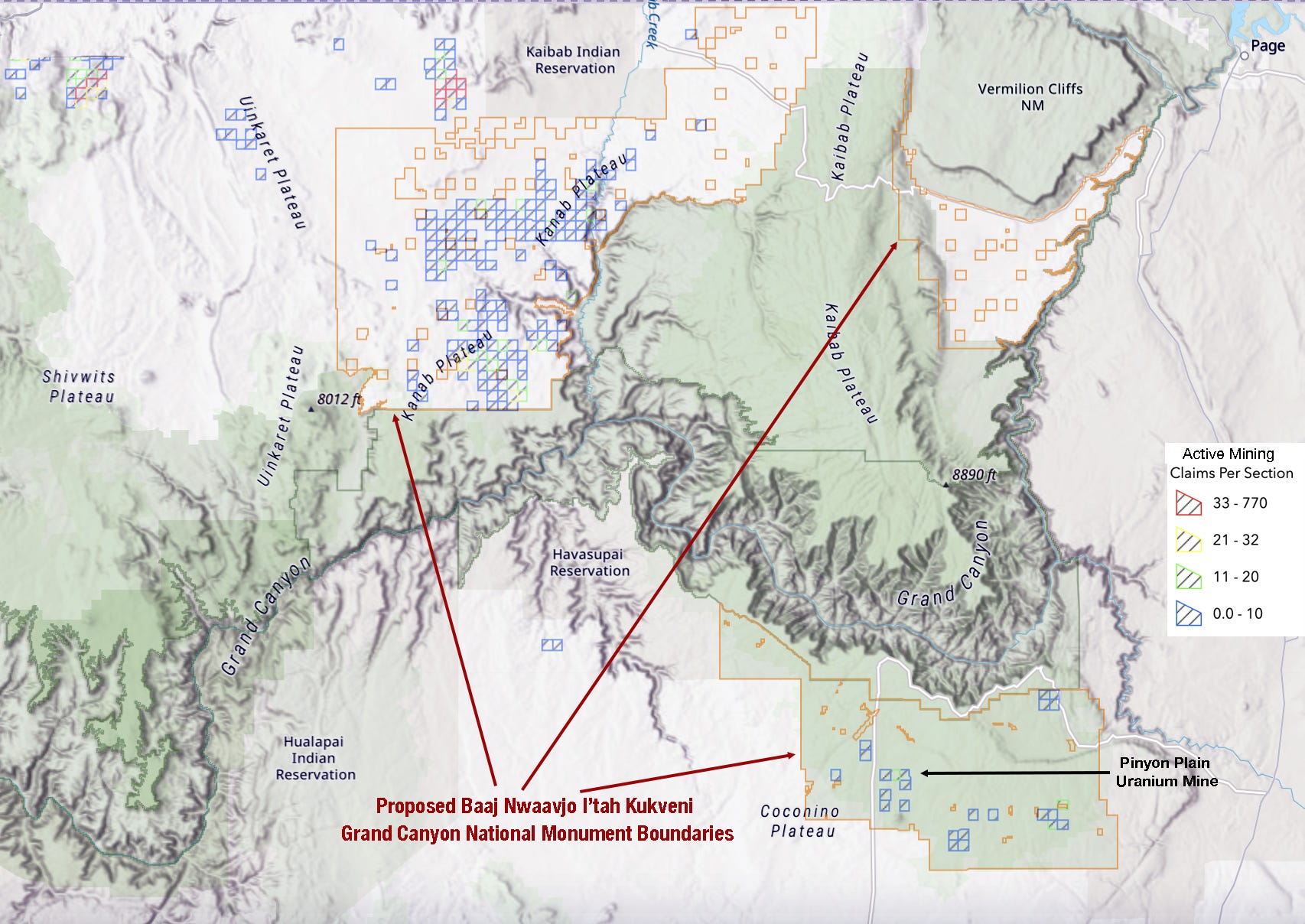

Discover more from The Land Desk
Ancestral Footprints national monument is a go
Move would protect nearly 1 million acres, ban new mining claims

President Joe Biden today designated the Baaj Nwaavjo I’tah Kukveni—Ancestral Footprints of the Grand Canyon National Monument on three sections of public land totaling about 917,000 acres in northern Arizona.
The Grand Canyon Tribal Coalition, made up of representatives from 13 tribal nations, proposed the monument designation and are applauding the announcement. Baaj Nwaavjo means “where tribes roam” in Havasupai; I’tah Kukveni means “ancestral footprints” in Hopi. The White House announcement suggests that the tribal nations will have a role in co-managing the new national monument.
One section of the national monument will adjoin the south edge of Grand Canyon National Park west of the Little Colorado River; another will lie between Marble Canyon and Vermillion Cliffs National Monument; and the largest swath will be on the Kanab Plateau, north of the Grand Canyon. The boundaries closely follow those of a 20-year ban on new mining claims established in 2012 by the Obama administration. The national monument will permanently withdraw the federal lands from new mining claims, but should not affect operations at Energy Fuels’ controversial Pinyon Plain Mine, which has an “active” permit, but lies dormant.
The effect on future uranium mining on other claims is less clear cut. Hundreds of existing, active mining claims lie within the new national monument, and the withdrawal and resulting protections don’t extend to existing valid claims, leases, or rights of way. In other words, the mining claims—and the rights that go along with them—will remain. Yet all claim-holders must get federal permits before doing any mining as well as rights of way or road-building permits to access the parcels. That’s likely to be far more difficult for claims within the national monument (although that could change with a more industry-friendly administration in the White House).
In a statement, Havasupai Tribe Chairman Thomas Siyuja Sr., responded to the announcement:
“The Havasupai Tribe celebrates this historic moment in time, but we also pause for a moment to honor our tribal ancestors who started this journey long ago. Many Havasupai tribal leaders have carried this battle on their shoulders over the decades and we are the fortunate ones to experience this unprecedented time in which our historic lands, water, sacred objects, and sites now hold the power and protection, which they rightfully deserve, under the supreme law of the land by the stroke of President Biden’s pen. President Biden’s action today will solidify our Tribe’s existence on, under, and over this land forever. Although there is still more work to do, we will sleep easier tonight knowing that our water, sacred sites, and plant medicines are more protected, and that our ancestors’ tears are finally tears of happiness.”
More from the ⛏️Mining Monitor⛏️
First, a reminder: We’re constantly updating the Land Desk Mining Monitor Map with new projects, new claims, and so forth. We’ve also added some very questionable claims staked in Bears Ears National Monument just prior to Obama’s designation and during Trump’s shrinkage, meaning they are now active, valid claims within the monument. More on that in a future edition.
A1 Lithium Incorporated’s Paradox Lithium exploratory drilling project near Dead Horse Point State Park outside of Moab is back on the table. The Bureau of Land Management in April revoked the company’s permit to drill a couple of exploratory wells. The agency apparently tweaked its analysis to address concerns brought up by the Southern Utah Wilderness Alliance. The proposal is up for public comment until Aug. 26. The Nevada firm and its many associated companies (Blackstone, Anson, etc) has been staking claims like crazy in the region, as reported by the Land Desk, and has big plans to extract and mechanically process lithium in the Moab and Green River areas.
There is a surprising amount of mining exploration activity going on in the La Plata Mountains of southwestern Colorado. The La Platas (as their name might indicate) have long been the target of mining companies, and some have hit pay dirt. Now a couple of firms are hoping to do it again.
Back in December, the U.S. Forest Service gave Alianza Minerals the green light to build up to nine exploratory drilling pads in the southern La Platas for its Twin Canyon Gold Project. The drilling will occur in the headwaters of Cherry Creek near the historic Charlene Mine.
And in June, Canada-based Metallic Minerals and the Phoenix-based Gault Group filed a notice of intent to do exploratory drilling on Montezuma Minerals' 97 un-patented mining claims near the head of Bedrock Creek in La Plata Canyon. They plan to pull up to 247,000 gallons of water per year from Boren, Bedrock, and Madden Creeks, and then replace the water by adding it -- presumably trucked in -- to the La Plata River where it crosses Highway 160 to ensure downstream water rights are honored. As for the stream segments between the diversion point and the highway? I guess they’re out of luck.Things are a bit weird with Atomic Mineral’s bid to mine uranium — or perhaps just investors — at Harts Point on the edge of Bears Ears National Monument. In July, Atomic Minerals and Kraken Energy both sent out press releases announcing the commencement of exploratory drilling at Harts Point. But as the Southern Utah Wilderness Alliance’s Neal Clark pointed out, Bureau of Land Management documents showed that the company had yet to pay its $58,000 reclamation bond, upon which the agency’s drilling approval was contingent. Meanwhile, the company had announced just a few days earlier that it was broke, meaning it was unlikely they could scrape up nearly $60k for a bond.
I don’t know if Atomic Minerals/Kraken ever actually started drilling, or what. But the BLM updated their case file, and it appears they have withdrawn their application to do so. Looks like the edge of Bears Ears is safe from the exploratory drills — at least for now. Here’s the sequence of events, according to the BLM case file:
Wildfire Watch

Fire season is underway and some level of smoke is blanketing much of the country. Most of that high-level haze is from Canada and even Alaska fires, while some Four Corners Country blazes are sending smaller plumes across the region.
Parting Shot

Ancestral Footprints national monument is a go
Trucking water to fill the La Plata River. Hmmm... that seems wrong on so many levels. Why not just pour petroleum in the river?!
If the feds are going to promote EV’s and stifle oil gas production as well as tie federal tax rebates to battery country of origin, why are they making it difficult to mine lithium? Sounds like tree huggers want their cake and eat it too!